
The Birdsville Track is a notable outback road in Australia. The 517-kilometre (321 mi) track runs between Birdsville in south-western Queensland and Marree, a small town in the north-eastern part of South Australia. It traverses three deserts along the route, the Strzelecki Desert, Sturt Stony Desert and Tirari Desert.

The Cooper Creek is a river in the Australian states of Queensland and South Australia. It was the site of the death of the explorers Burke and Wills in 1861. It is sometimes known as the Barcoo River from one of its tributaries and is one of three major Queensland river systems that flow into the Lake Eyre basin. The flow of the creek depends on monsoonal rains falling months earlier and many hundreds of kilometres away in eastern Queensland. It is 1,300 kilometres (810 mi) in length.
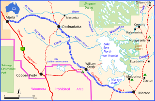
The Oodnadatta Track is an unsealed 614 km (382 mi) outback road in the Australian state of South Australia, connecting Marla in the north-west via Oodnadatta to Marree in the south-east. Along the way, the track passes the settlements of Oodnadatta and William Creek, the southern lake of the Kati Thanda-Lake Eyre National Park, and mound springs known as Freeling Springs, Strangways Springs, and The Bubbler and Blanche Cup.

Innamincka, formerly Hopetoun, is a township and locality in north-east South Australia with a population of 44 people as of the 2016 census. By air it is 820 kilometres north-east of the state capital, Adelaide, and 365 kilometres north-east of the closest town, Lyndhurst. It is 66 kilometres north-east of the Moomba Gas Refinery. The town lies within the Innamincka Regional Reserve and is surrounded by the Strzelecki Desert to the south and the Sturt Stony Desert to the north. It is linked by road to Lyndhurst via the Strzelecki Track, to the Birdsville Developmental Road via Cordillo Downs Road and Arrabury Road, and the Walkers Crossing Track to the Birdsville Track. The Walkers Crossing Track is closed in summer and only traversable in dry weather. The township is situated along the Cooper Creek, a part of the Lake Eyre basin.
Lyndhurst is a town in north-east South Australia which is at the crossroads of the Strzelecki Track and the Oodnadatta Track. It began as a railway siding in 1878.

The Strzelecki Desert is located in the Far North Region of South Australia, South West Queensland and western New South Wales. It is positioned in the northeast of the Lake Eyre Basin, and north of the Flinders Ranges. Two other deserts occupy the Lake Eyre Basin—the Tirari Desert and the Simpson Desert.

The Great Central Road is a mostly unsealed Australian outback highway that runs 1,126 km (700 mi) from Laverton, Western Australia to Yulara, Northern Territory. It passes through a number of small communities on the way.

The Buchanan Highway, Northern Territory, Australia, runs west from Birdum on the Stuart Highway crossing the Buntine Highway at Top Springs and eventually connecting with the Victoria Highway near Timber Creek. As of 2007 it was unsealed for its entire length, at 393 kilometres (244 mi). Funding for maintenance is provided by the Northern Territory Government.

The Bore Track is a 4WD track in South Australia roughly following the Queensland border from Cameron Corner to Innamincka. It is a narrow, rarely used, scenic alternative to the Strzelecki Track, passing through sand dunes and clay pans of the Strzelecki Desert. It is a good preparation for the longer traverse of the Simpson desert. There are gas fields, pipelines and bores for which the track is the historic access and after which it is named.

The Tirari Desert is a 15,250 square kilometres (5,888 sq mi) desert in the eastern part of the Far North region of South Australia. It stretches 212 km from north to south and 153 km from east to west.

Cordillo Downs or Cordillo Downs Station is both a pastoral lease currently operating as a cattle station and a formal bounded locality in South Australia. It is located about 116 kilometres (72 mi) north of Innamincka and 155 kilometres (96 mi) south east of Birdsville. The name and boundaries of the locality were created on 26 April 2013 for the long established local name.
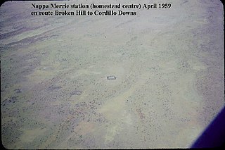
Nappa Merrie Station, most commonly known as Nappa Merrie, is a pastoral lease that operates as a cattle station in central west Queensland, Australia.
Blanchewater Station is a pastoral lease that operates as a cattle station in the far north of South Australia.
Tinga Tingana Station was a pastoral lease that once operated as a sheep station in outback South Australia.
Merty Merty is both a pastoral lease that once operated as a cattle station in north east South Australia. In April 2013, the land occupying the appropriate extent of the pastoral lease was gazetted by the Government of South Australia as a locality under the name Merty Merty.
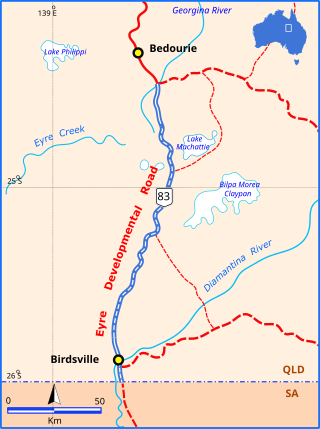
The Eyre Developmental Road is a gazetted road in south-west Queensland that runs from Bedourie to Birdsville and then to the border with South Australia, where it continues as the Birdsville Track. At the northern end it joins the Diamantina Developmental Road, and the mostly unsealed road crosses the Georgina River and Diamantina River. Maintenance of the road is the responsibility of the Queensland State Government. The road intersects with the Birdsville Developmental Road in Birdsville.
Gidgealpa is a locality in the Australian state of South Australia located about 780 kilometres north-east of the capital city of Adelaide and about 58 kilometres south-west of the town of Innamincka.
The Strzelecki Creek, part of the Lake Eyre basin, is an ephemeral watercourse located in the Australian state of South Australia.
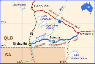
The Birdsville Developmental Road is a mostly unsealed road in south-west Queensland that branches off the Diamantina Developmental Road at a point 103 kilometres (64 mi) west of Windorah and runs to Birdsville. Its length is 273 kilometres (170 mi). The road crosses a major channel of the Diamantina River just before reaching Birdsville. It links with Cordillo Downs road and Arrabury Road, both of which lead to the South Australian town of Innamincka.
The Adventure Way is an Australian outback route between Brisbane, Queensland and Innamincka, South Australia. Using the Adventure Way, it is 1,152 kilometres (716 mi) from Brisbane to Innamincka. The recommended journey time, allowing for some sightseeing, food and rest is 96 hours. It has been designated by the Queensland Government as a State Strategic Touring Route.


