
Barrier Highway is a highway in South Australia and New South Wales, and is designated part of route A32. The name of the highway is derived from the Barrier Ranges, an area of moderately high ground in the far west of New South Wales, through which the highway traverses.
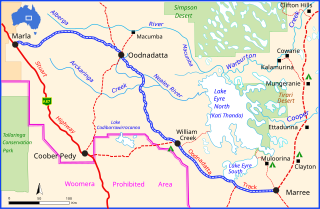
The Oodnadatta Track is an unsealed 614 km (382 mi) outback road in the Australian state of South Australia, connecting Marla in the north-west via Oodnadatta to Marree in the south-east. Along the way, the track passes the settlements of Oodnadatta and William Creek, the southern lake of the Kati Thanda-Lake Eyre National Park, and mound springs known as Freeling Springs, Strangways Springs, and The Bubbler and Blanche Cup.
Mallee Highway is a highway connecting Tailem Bend in south-eastern South Australia and Piangil in north-western Victoria, running mostly across the Mallee plains. It forms part of the shortest route between Adelaide and Sydney.
Greenhill Road is a major road in Adelaide, South Australia, that provides a connection to the eastern and hills suburbs. Its western section, running along the south side of Adelaide Parklands, forms part of Adelaide's City Ring Route.

Glen Osmond Road is a major section of the Princes Highway in the city of Adelaide, South Australia. Connecting the Adelaide city centre with the Adelaide Hills via the South Eastern Freeway; Glen Osmond Road carries half of Adelaide's freight traffic and is the major commuter route from the southern Adelaide Hills. It is designated part of route A1.
Glenelg Highway is a rural highway in south-eastern Australia, linking the major regional centres of Mount Gambier in south-eastern South Australia with Ballarat in western Victoria.

Sir Donald Bradman Drive is a major arterial road that travels east–west through the western suburbs of Adelaide, South Australia. It is the main route from the Adelaide city centre to the Adelaide Airport.

Wimmera Highway is a 345 kilometre rural highway that runs predominately through the Wimmera region of western Victoria, after which the highway is named. It links the towns of Marong, Victoria, just to the west of the major regional centre of Bendigo in Victoria, and Naracoorte, in the south-eastern corner of South Australia.
Victoria Road is a major road in Adelaide, South Australia, connecting Port Adelaide to Outer Harbor on the Lefevre Peninsula. It is designated part of route A16.
Gawler Bypass is a major north–south route in the outer northern suburbs of the city of Adelaide, South Australia, connecting Main North Road to the Sturt Highway, bypassing Gawler. The route was built in 1963 in an attempt to redirect traffic on the national highway out of Gawler town centre. It has been upgraded and realigned several times since then.
Adelaide has two city ring routes, that loop around the Adelaide city centre and North Adelaide, known as the Inner and Outer Ring Routes.
Onkaparinga Valley Road is a South Australian secondary road, connecting the towns of Birdwood, Woodside, Balhannah and Verdun within the Adelaide Hills. It is designated part of route B34.
Marion Road is a north–south arterial road through the western suburbs of Adelaide, South Australia, named after its traversal through the suburb of Marion and the local government area of City of Marion. It is designated part of route A14.
Regency Road is a main east-west road forming a continuous connection between the inner northern suburbs of Adelaide, South Australia. Located approximately 6 kilometres (3.7 mi) north of the city centre, Regency Road carries a large amount of freight traffic, being located near Regency Park and the Churchill Road industrial area.
Churchill Road is an arterial road in the inner northern suburbs of Adelaide, Australia.
Birdseye Highway is an east–west road across Eyre Peninsula in South Australia. It was named for Sylvia Birdseye who drove the first bus service to the area from Adelaide for 43 years, starting in 1928, and is the first highway in South Australia to be named for a woman.
Stott Highway is a 144-kilometre-long (89 mi) state-controlled highway in South Australia, linking Angaston in the Barossa Valley, through Sedan and Swan Reach, to Pyap in the Riverland region. It was named after Tom Stott, a member of the South Australian state parliament.
Playford Highway is a main road on Kangaroo Island in South Australia, with its eastern end designated part of route B23. It extends from Kingscote through Cygnet River and Parndana to Cape Borda.
Grange Road is an arterial road in the western suburbs of Adelaide, South Australia. It runs from the coast at Grange to South Road, close to the city centre.
Unley Road is a road in the City of Unley, located south of the City of Adelaide, the capital of South Australia. It runs from South Terrace to Cross Road, where it becomes Belair Road. The road was named after the family name of the wife of Thomas Whistler, owner of land in Unley which was laid out around 1857.
