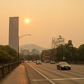
2015 Oregon wildfires

Last updated
2015 Oregon wildfires
Fire Retardant Drop, Deschutes NF, Oregon, 2015.jpg
Air tanker dropping fire retardant on a wildfire in Central Oregon
Statistics [1]
Total fires2,588
Total area685,809 acres (2,775.37 km2)
Season
  2014
2016  

The 2015 Oregon wildfires were an ongoing series of wildfires affecting parts of the U.S. state of Oregon.

Contents

August fire

The August fire was reported on August 22, 2015, 10 miles (16 km) east of Banks. It was fully contained by August 24. It was suspected to be human-caused. One firefighter was injured. Three aircraft were used, taking water from Henry Hagg Lake, which led to its closure for recreational purposes. An estimated 26 acres (11 ha) were part of the burn, and 60 firefighters were needed. Highway 26 was closed for several days. [2] [3]

Cornet-Windy Ridge fire

The Cornet-Windy Ridge fire has burned more than 103,800 acres (42,000 ha) on public forest and private lands a few miles west of Durkee. As of August 23, 2015, the fire was 80 percent contained. [4]

Eldorado fire

The Eldorado fire, which was caused by lightning, has burned more than 20,600 acres (8,300 ha) of land 5 miles (8.0 km) southeast of Unity. As of August 23, 2015, the fire was 65 percent contained. [4]

Stouts fire

The human-caused Stouts fire has burned 26,000 acres 16 miles (26 km) east of Canvyonville, just south of Milo. As of August 23, 2015, the wildfire was 83 percent contained. [4]

Willamina Creek fire

The Willamina Creek fire, occurring 9 miles (14 km) north of Willamina, has burned 230 acres (93 ha) in "heavy fuels on high-value timberland owned by the Bureau of Land Management and private industrial forestland owners". As of August 23, 2015, the fire was 20 percent contained. [4]

Smoke in the Willamette Valley

Wildfire smoke from Washington and Oregon was blown west over western Oregon, including Portland and the rest of the Willamette Valley, on August 22–23, 2015. [5] [6]

See also

Related Research Articles

<span class="mw-page-title-main">Forest Park (Portland, Oregon)</span> Public municipal park west of downtown Portland, Oregon

Forest Park is a public municipal park in the Tualatin Mountains west of downtown Portland, Oregon, United States. Stretching for more than 8 miles (13 km) on hillsides overlooking the Willamette River, it is one of the country's largest urban forest reserves. The park, a major component of a regional system of parks and trails, covers more than 5,100 acres (2,064 ha) of mostly second-growth forest with a few patches of old growth. About 70 miles (110 km) of recreational trails, including the Wildwood Trail segment of the city's 40-Mile Loop system, crisscross the park.

<span class="mw-page-title-main">Schultz Fire</span> 2010 wildfire in Arizona

The Schultz Fire was a wildfire which burned over 15,000 acres (6,100 ha), including Schultz Peak in Coconino National Forest near Flagstaff, Arizona, in June 2010. The suspected cause is a campfire left unattended, and the United States Forest Service is offering a $2500 reward for information.

<span class="mw-page-title-main">Tumblebug Complex Fire</span>

The Tumblebug Complex Fire burned 14,570 acres (5,900 ha) of Willamette National Forest land in Lane County, Oregon, United States, from September 12, 2009 to October 2009. The fire was located about 23 miles (37 km) southeast of Oakridge, Oregon, and roughly 5 miles (8.0 km) southwest of Crescent Lake.

<span class="mw-page-title-main">2015 Washington wildfires</span>

The 2015 wildfire season was the largest in Washington state history, with more than one million acres burning across the state from June to September. As many as 3,000 firefighters including 800 Washington National Guard members were deployed to fight the fires. The 17th Field Artillery Brigade of the United States Army also deployed 200 soldiers from Joint Base Lewis–McChord to help fight the fires.

<span class="mw-page-title-main">Lava Fire (2012)</span> 2012 wildfire in Oregon

The Lava Fire was a wildfire that burned over 21,500 acres (87 km2) of Oregon rangeland during the summer of 2012. The fire began on 23 July 2012, the result of a lightning strike. The fire consumed rangeland vegetation and scrub forest located in and around lava beds in northern Lake County. The burned area was on public land administered by the Bureau of Land Management including a large area within a wilderness study area. Firefighters battled the blaze for over three weeks. At the peak of the firefighting effort, there were over 275 personnel working on the fire.

<span class="mw-page-title-main">Barry Point Fire</span> Wildfire

The Barry Point Fire was a wildfire that burned over 92,977 acres (376.26 km2) of Oregon and California forest land during the summer of 2012. The fire began on 5 August 2012, the result of a lightning strike. The fire consumed public forest and rangeland as well as private forest and grazing land located in Lake County, Oregon and Modoc County, California. The public lands effected by the fire are administered by the United States Forest Service and the Oregon Department of Forestry. The largest part of the private land was owned by the Collins Timber Company. At the peak of the firefighting effort, there were 1,423 personnel working on the fire. It took 22 days to fully contain the fire and then an additional three weeks to mop it up.

<span class="mw-page-title-main">Rocky Mount Fire of 2016</span>

On Friday, April 16, 2016, a 200-acre (81 ha) forest fire was first reported in Shenandoah National Park in the U.S. state of Virginia. The fire originated in the area around Rocky Mount, a mountain in the south district of the park, in a remote region south of Elkton, Virginia. The fire was west of Skyline Drive, the scenic byway that runs through the park. By April 17, the fire had spread to over 500 acres (200 ha), prompting closures of Skyline Drive from mile markers 65 at Swift Run Gap to 79 at Loft Mountain. Additionally, more than a dozen hiking trails were closed, including a section of the Appalachian Trail. By Monday April 18, officials reported that the fire had spread to over 2,000 acres (810 ha) and that a Type 1 incident management team and several hotshot firefighting crews had been dispatched to address the situation. By Wednesday April 20, more than 200 firefighters were on scene or en route, supported by two helicopters carrying water buckets and eight fire engines. National Park Service officials reported on the morning of April 20 that the fire had spread to 4,000 acres (1,600 ha) and that 250 firefighting personnel were engaged in establishing firelines in an effort to control the blaze. By that evening, officials had reported that the fire had expanded to roughly 5,616 acres (2,273 ha) and that at mile marker 76 on Skyline Drive, the fire had crossed the road and burned another 80 to 100 acres. The fire was only 1 percent contained and full containment was not anticipated until April 30 because of ongoing weather conditions favoring fire growth. By the evening of Thursday, April 21, the fire had expanded to 7,935 acres (3,211 ha) and more than 300 firefighting and support personnel had been assigned to the fire. The fire expanded to 8,952 acres (3,623 ha) and 342 firefighters were assigned to the fire by the evening of April 22.

<span class="mw-page-title-main">Sherpa Fire</span> 2016 wildfire in California

The Sherpa Fire was a wildfire that burned in the Santa Ynez Mountains along the Gaviota Coast in the southwestern part of Santa Barbara County, California in June 2016. In a matter of hours the fire spread to over 1,400 acres (570 ha) as the fire was propelled by downslope sundowner winds. This offshore northerly wind contrasts with the more typical onshore flow and sent the fire down the canyons towards the ocean with gusts of over 35 miles per hour (56 km/h). The wildfire resulted in evacuations at two state beach campgrounds and some residences together with intermittent interruption of traffic on a state transportation route.

<span class="mw-page-title-main">Eagle Creek Fire</span> Major 2017 wildfire in Columbia Gorge, Oregon

The Eagle Creek Fire was a destructive wildfire in the Columbia River Gorge, largely in the U.S. state of Oregon, with smaller spot-fires in Washington. The fire was started on September 2, 2017, by a 15-year-old boy igniting fireworks during a burn ban. The fire burned 50,000 acres, and burned for three months, before being declared completely contained. As late as May 29, 2018, it was still found smoldering in some areas.

<span class="mw-page-title-main">2017 Oregon wildfires</span>

The 2017 Oregon wildfires were a series of wildfires that burned over the course of 2017.

<span class="mw-page-title-main">Milli Fire</span> 2017 wildfire in the U.S. state of Oregon

The Milli Fire was a wildfire that burned over 24,000 acres (97 km2) of Oregon forest land during the summer of 2017. The fire began in the Deschutes National Forest on 11 August 2017, the result of a lightning strike. The fire consumed thick forest vegetation southwest of Sisters, Oregon. Most of the burned area was public lands administered by the United States Forest Service, much of it in the Three Sisters Wilderness. Firefighters battled the blaze for over a month. At the peak of the firefighting effort, there were 675 firefighters working on the Milli Fire.

<span class="mw-page-title-main">Cinder Butte Fire</span> 2017 wildfire in Oregon

The Cinder Butte Fire was a wildfire that burned over 52,000 acres (210 km2) of Oregon rangeland during the summer of 2017. The fire began on 2 August 2017. It was determined to be human-caused since lightning was not present in the area prior to the initial fire report. The fire consumed rangeland vegetation and juniper woodlands in the area east of Glass Buttes in northern Lake County and then spread into northwestern Harney County. Most of the burned area was on public land administered by the Bureau of Land Management. Firefighters battled the blaze for over a week. At the peak of the firefighting effort, there were 496 firefighters working on the Cinder Butte Fire.

<span class="mw-page-title-main">2018 Washington wildfires</span>

The 2018 Washington wildfire season officially began June 1, 2018. A statewide state of emergency was declared by Governor Jay Inslee on July 31.

<span class="mw-page-title-main">2020 Washington wildfires</span>

The 2020 Washington wildfire season officially began in March 2020. The season was a part of the 2020 Western United States wildfires. By September, wildfires had burned over 713,000 acres, 181 homes had been lost, and one death occurred as a result. The 2020 fire season saw more individual fires than in any other recorded year.

<span class="mw-page-title-main">2020 Western United States wildfire season</span> Wildfires in the United States in 2020

The Western United States experienced a series of major wildfires in 2020. Severe August thunderstorms ignited numerous wildfires across California, Oregon, and Washington, followed in early September by additional ignitions across the West Coast. Fanned by strong, gusty winds and fueled by hot, dry terrains, many of the fires exploded and coalesced into record-breaking megafires, burning more than 10.2 million acres of land, mobilizing tens of thousands of firefighters, razing over ten thousand buildings, and killing at least 37 people. The fires caused over $19.884 billion in damages, including $16.5 billion in property damage and $3.384 billion in fire suppression costs. Climate change and poor forest management practices contributed to the severity of the wildfires.

The 2021 Washington wildfire season officially began in March 2021. By late April, all of Eastern Washington had been classified by the United States Drought Monitor as "abnormally dry" with moderate to severe drought conditions. The state had more than 630 wildfires by the first week of July, on par with the state's record 2015 wildfire season.

<span class="mw-page-title-main">Lava Fire (2021)</span> 2021 wildfire in California

The Lava Fire was a wildfire that burned 26,409 acres (10,687 ha) along the slopes of Mount Shasta near Weed, California during the 2021 California wildfire season. The fire started on June 25, 2021 and was fully contained on September 3, 2021. The fire destroyed 23 buildings, including 14 houses, as well as damaged an additional building.

<span class="mw-page-title-main">Bootleg Fire</span> 2021 wildfire in the U.S. state of Oregon

The Bootleg Fire, named after the nearby Bootleg Spring, was a large wildfire that started near Beatty, Oregon, on July 6, 2021. Before being fully contained on 15 August 2021, it had burned 413,765 acres. It is the third-largest fire in the history of Oregon since 1900. At the fire's fastest growth in mid July, it grew at about 1,000 acres (400 ha) per hour, and it became the second largest wildfire in the United States of the 2021 wildfire season.

<span class="mw-page-title-main">2022 Washington wildfires</span> Wildfire season

The 2022 Washington wildfire season officially began in March 2022. As of August 4, 2022, there have been four large wildfires that have burned 30,800 acres (12,500 ha) across the US state of Washington. This season started quieter than normal due to unusually colder weather that kept Eastern and Southeastern Washington burning index's largely below normal into July. As of October 2022, a total of 140,000 acres (57,000 ha) of land in the state was burned – the fewest number of acres burned since 2012.

<span class="mw-page-title-main">2022 Oregon wildfires</span> Wildfires in the U.S. state of Oregon in 2022

The 2022 Oregon wildfire season was a series of wildfires burning in the U.S. state of Oregon.

References

  1. "National Report of Wildland Fires and Acres Burned by State 2015" (PDF). National Interagency Fire Center . Archived from the original (PDF) on 28 June 2018. Retrieved 31 August 2016.
  2. "Brush fire that closed U.S. 26 caused by person, authorities say". OregonLive.com . Retrieved 24 August 2015.
  3. "August Fire contained, but U.S. 26 road closure continues (photos)". OregonLive.com . Retrieved 24 August 2015.
  4. 1 2 3 4 Alteir, Nuran (August 23, 2015). "Northwest wildfires: Crews make progress on some blazes while containment stagnates elsewhere". The Oregonian. Retrieved August 24, 2015.
  5. Denson, Bryan (August 22, 2015). "Wind blows wildfire smoke over Cascades into Portland area, triggering unhealthy readings in Beaverton, Government Camp". The Oregonian. Retrieved December 2, 2015.
  6. "Air Quality Slips To 'Unhealthy' Levels Due To Wildfire Smoke". OPB News. Oregon Public Broadcasting. August 22, 2015. Retrieved December 2, 2015.