
Monterey County, officially the County of Monterey, is a county located on the Pacific coast in the U.S. state of California. As of the 2020 census, its population was 439,035. The county's largest city and county seat is Salinas.
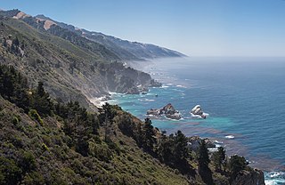
Big Sur is a rugged and mountainous section of the Central Coast of the U.S. state of California, between Carmel Highlands and San Simeon, where the Santa Lucia Mountains rise abruptly from the Pacific Ocean. It is frequently praised for its dramatic scenery. Big Sur has been called the "longest and most scenic stretch of undeveloped coastline in the contiguous United States", a sublime "national treasure that demands extraordinary procedures to protect it from development", and "one of the most beautiful coastlines anywhere in the world, an isolated stretch of road, mythic in reputation". The views, redwood forests, hiking, beaches, and other recreational opportunities have made Big Sur a popular destination for visitors from across the world. With 4.5 to 7 million visitors annually, it is among the top tourist destinations in the United States, comparable to Yosemite National Park, but with considerably fewer services, and less parking, roads, and related infrastructure.

The Esselen are a Native American people belonging to a linguistic group in the hypothetical Hokan language family, who are Indigenous to the Santa Lucia Mountains of a region south of the Big Sur River in California. Prior to Spanish colonization, they lived seasonally on the coast and inland, surviving off the plentiful seafood during the summer and acorns and wildlife during the rest of the year.

The Salinas River is the longest river of the Central Coast region of California, running 175 miles (282 km) and draining 4,160 square miles (10,800 km2). It flows north-northwest and drains the Salinas Valley that slices through the central California Coast Ranges south of Monterey Bay. The river begins in southern San Luis Obispo County, originating in the Los Machos Hills of the Los Padres National Forest. From there, the river flows north into Monterey County, eventually making its way to connect with the Monterey Bay, part of the Pacific Ocean, approximately 5 miles (8.0 km) south of Moss Landing. The river is a wildlife corridor, and provides the principal source of water from its reservoirs and tributaries for the farms and vineyards of the valley.

Abies bracteata, the Santa Lucia fir or bristlecone fir, is the rarest fir in North America, and according to some, the world. It is confined to steep-sided slopes and the bottoms of rocky canyons in the Santa Lucia Mountains, in the Big Sur region on the central coast of California, United States.
California's 18th congressional district is a congressional district located in the U.S. state of California. The district is currently represented by Democrat Zoe Lofgren. Since the 2022 election, the district is landlocked and includes all of San Benito County and parts of Santa Clara and Monterey counties, including Salinas, Hollister, Watsonville, Gilroy, Soledad, and downtown and eastern San Jose.
California's 19th congressional district is a congressional district in the U.S. state of California, currently represented by Democrat Jimmy Panetta.

The Tassajara Zen Mountain Center is the oldest Japanese Buddhist Sōtō Zen monastery in the United States. It is on the border of the Ventana Wilderness and within the Los Padres National Forest, southeast of Carmel-by-the-Sea, California. The center is only accessible over 5,082 feet (1,549 m) high Chews Ridge via a narrow, steep, 13.7 miles (22.0 km) one-lane dirt road from Jamesburg. During the winter months the center can be inaccessible due to snow and rain. Practitioners live and study on site. From Memorial Day to Labor Day, the center is open to day and overnight guests. The natural hot springs have been developed into Japanese-style baths. A steam bath is built over a hot spring in Tassajara Creek. The center is the first Zen monastery established outside Asia.
Sycamore Valley Regional Open Space Preserve is a regional park in Contra Costa County, California, outside of Danville, California, United States that is part of the East Bay Regional Parks (EBRPD) system.
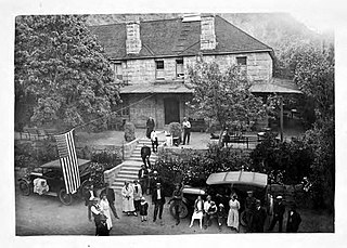
Tassajara Hot Springs is a collection of natural hot springs within the Ventana Wilderness area of the Santa Lucia Range and Los Padres National Forest in Monterey County, California. The hot springs were used by the indigenous Native Americans for generations before they were discovered by Europeans in about 1843. The springs have been the site of various resorts since 1868. A horse trail was in use until in 1886, when a stagecoach road was constructed over Chews Ridge to the springs. Monterey County designated the road to the resort as a public highway in June, 1870. Charles Quilty bought the resort in 1886. He had a sandstone hotel built. He and members of his family owned the springs until 1945. The new owners refurbished the hotel but it burned in a fire in 1949. The resort changed hands several times over the next three decades. One owner planned to add a helicopter service, but he was killed in an airplane crash. Since 1967, the hot springs have been the site of a Zen Buddhist monastery which is open to visitors during the summer months only.

The San Ramon Valley Fire Protection District provides fire protection and emergency medical services for the cities of Alamo, Blackhawk, Danville, Diablo, Camino Tassajara and San Ramon as well as southern areas of the Morgan Territory in California, United States. In all, the district is responsible for 155 square miles (400 km2) with a population of approximately 192,800.
The Oliver Observing Station is an independent professional astronomical observatory named after Barnard M. Oliver. It is owned and operated by The Monterey Institute for Research in Astronomy (MIRA).
The Pine Ridge Trail is the most popular hiking trail in the Ventana Wilderness of the Los Padres National Forest, California. The 19.5 miles (31.4 km) trail traverses the Ventana Wilderness from the Big Sur Station near sea level to China Camp on Tassajara Road at 5,000 feet (1,500 m). Built in 1916 by the Post family of Big Sur, the Pine Ridge Trail offers hikers and equestrians an array of backcountry camps to enjoy.
Tassajara Creek Regional Park (TCRP) is a park near Dublin in the U.S. state of California, which has been called one of the most obscure parks in the East Bay Regional Park System. It is located adjacent to the eastern boundary of Camp Parks and was established in 1991 as a staging facility for the Tassajara Creek Regional Trail. Because of TCRP's small size—27 acres (11 ha)—and the existence of a security fence along the Camp Parks boundary, usage of the park by both humans and wildlife is limited.

The Ventana Wilderness Alliance, founded in 1998, is a 501 c 3 nonprofit organization dedicated to protecting the of California's Big Sur backcountry. Its mission is to protect, preserve, and restore the wilderness qualities and biodiversity of the public lands within California's Northern Santa Lucia Mountains and Big Sur region.

The Chews Ridge Lookout is located at the northern end of the Santa Lucia Range of the Los Padres National Forest, about 50 miles (80 km) southeast of Monterey, California and approximately 30 miles (48 km) west of Highway 101. The current tower was built in 1929 and staffed until around 1990. A volunteer organization began recruiting individuals to staff the tower in 2019. The ridge and tower were named for homesteaders Constantine and Nellie Chew, who patented 315 acres (127 ha) on the ridge in the late 19th century.
The River Fire was a wildfire that broke out from a lightning storm early on August 16, 2020 in Monterey County, California, south of Salinas, near River Road and Mount Toro. Within its first day, it spread to 2,000 acres and was 10% contained; mandatory evacuations were ordered, while air and ground crews worked the fire.
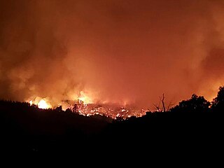
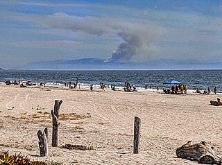
The Dolan Fire was a large wildfire that burned in the Big Sur region and other parts of the Santa Lucia mountain range in Monterey County, California, in the United States as part of the 2020 California wildfire season. The fire began at approximately 8:15 p.m. on August 18, 2020. On September 8, 15 firefighters were injured, one critically, when they were forced to deploy emergency fire shelters at Nacimiento Station. Ten adult California condors and two chicks died in the blaze, which began about a mile south of the Big Sur Condor Sanctuary in Monterey County. The nonprofit Ventana Wildlife Society of Monterey lost a sanctuary that has been used to release the captive-bred condors into the wild since 1997. While no people or condors were at the 80-acre (32 ha) site, a research building, pens, and other facilities were destroyed.
The Willow Fire was a wildfire that burned in the Ventana Wilderness in Monterey County, California, in the United States as part of the 2021 California wildfire season. The fire started on June 17, 2021, burned 2,877 acres (1,164 ha), and was fully contained on July 12, 2021. The cause of the fire is under investigation and is currently unknown.

