Chips Fire

Last updated

Chips Fire
2012 Chips Fire burning 4.jpg
The Chips Fire producing a large smoke column on August 2, 2012
Date(s)
  • July 29, 2012 (2012-07-29)
  • August 31, 2012 (2012-08-31)
  • (34 days)
Location Plumas County, Northern California, United States
Coordinates 40°00′36″N121°16′41″W / 40.01°N 121.278°W / 40.01; -121.278 [1]
Statistics
Burned area75,431 acres (30,526 ha; 118 sq mi; 305 km2)
Impacts
Structures destroyed9
Damage
  • $55 million
  • (equivalent to about $72.2 million in 2023)
Ignition
CauseHuman-caused
Map
Chips fire 2.png
The Chips Fire burned in the North Fork Feather River Canyon, south of Lake Almanor
USA California Northern location map.svg
FireIcon.svg
The fire burned in the northern Sierra Nevada, affecting Plumas and Lassen counties

The 2012 Chips Fire was a large wildfire in California's Plumas County. After igniting on July 29, the fire burned for 33 days and consumed 75,431 acres (30,526 hectares), or more than 118 square miles (310 square kilometres), before it was fully contained on August 31. [2] In the process it became the second-largest fire of California's 2012 wildfire season after the Rush Fire in Lassen County.

Contents

The Chips Fire burned in the northern Sierra Nevada, primarily impacting Plumas National Forest and private timberlands. While the fire threatened nearby communities, such as Belden and Prattville, it only destroyed nine structures. The cost of the firefighting effort was estimated at $55 million. The fire started directly adjacent to the Pacific Crest Trail and was determined to have been human-caused, but no specific cause or perpetrator was ever determined. [3]

Background

A combination of conducive weather, fuels (vegetation), and terrain made the fire resistant to control. A U.S. Forest Service report analyzing the factors that contributed to the Chips Fire's behavior and spread concluded that the fire "burned with high intensity because of high fuel loads, very dry fuels, and steep topography. Winds were mostly calm, but relative humidity was low and temperatures high." [4] :26

The spread of the Chips Fire was driven by typical August weather for the region, with mild (<10-mile-per-hour (16 km/h) diurnal winds, extremely low relative humidity levels that fluctuated between 10 and 20 percent, and high temperatures usually exceeding 80 °F (27 °C) and occasionally exceeding 100 °F (38 °C). [4] :12–13 The Forest Service regarded the Haines Index, a weather index intended to measure the potential for dry and unstable air, as a good predictor of intense wildfire behavior and growth during the Chips Fire. [4] :16

During the winter and spring of 2011–2012, a low snowpack dried out fuels on the ground. Consequently, 1,000-hour fuel moistures were critically low—below 10 percent—at the time of the fire. [4] :10 The lack of snow, as well as cold snaps, helped kill brush. Snags from the Storrie Fire also remained: the area of the burn where the Chips Fire began had not been salvage logged, and multiple wind events over the winter of 2011–2012 broke many snag tops off, contributing to ground fuel loading. [4] :8–10

A map of terrain slope within the Chips Fire footprint, with darker shades of red representing steeper slopes 2012 Chips Fire map 3.jpg
A map of terrain slope within the Chips Fire footprint, with darker shades of red representing steeper slopes

The Chips Fire was also difficult to combat in part because of the steep and inaccessible terrain it began in, along the Feather River Canyon watershed. [4] :3 The canyon has witnessed many large wildfires in recent decades, including the 1999 Bucks Fire, the 2000 Storrie Fire, the 2008 BTU Lightning Complex, the 2018 Camp Fire (infamous for its fatal wind-driven run out of the Feather River Canyon), and the 2021 Dixie Fire (the largest single wildfire in recorded California history). [5] [6] The canyon is steep and rugged, in some places rising more than 5,000 feet (1,500 m) from the Feather River to surrounding peaks. [7] [8] The majority of the Chips Fire burn area consisted of slopes between 55 percent and 70 percent. [4] :10

Progression

July 29–31

The Chips Fire was first spotted by firefighters on July 29, 2012, at 1:52 a.m. PDT as a 10-acre (4.0 ha) fire on the eastern slope of the Chips Creek drainage, a mile above Highway 70 in the Feather River Canyon. [9] :22 Burning on both sides of the Pacific Crest Trail in the Plumas National Forest, the fire was determined to have been human-caused. [3]

As resources arrived through the early morning hours, incident command noted the various difficulties of initial attack (including steep terrain, power lines, snags from previous fires, and a drainage aligned with prevailing winds) and assessed the probability of success in direct attack as "difficult but possible." Air tankers arrived by 11:30 a.m., and over the course of the day fixed-wing air tankers dropped 33 loads of fire retardant and helicopters dropped 133,000 gallons of water on the fire. However, the effectiveness of those drops was limited, as the steep terrain and dry/dead fuels led to spotting and roll-out of burning material. The fire was between 25 acres (10 ha) and 50 acres (20 ha) by the end of the first day shift. [9] :22–23

On July 30 and 31, firefighters continued to engage in direct attack on the fire as it burned slowly through the footprints of the 2008 Belden Fire and the 2000 Storrie Fire. The fire increased in activity on July 31, spotting from the Chips Creek drainage into the Indian Creek drainage. The fire was estimated at approximately 1,000 acres (400 ha) by the end of the 31st. [9] :23–24

August

The Chips Fire puts up a smoke column in early August 2012 Chips Fire burning 1.jpg
The Chips Fire puts up a smoke column in early August

The Chips Fire remained quite active on August 1. The fire developed a convective column, becoming "plume-dominated" in its behavior, and grew significantly to the north after spotting into the Yellow Creek drainage. More significantly, the fire also spotted 1.5 miles (2.4 km) to the east (over both the primary and proposed secondary contingency lines) onto Caribou Ridge. By the end of the day, the fire was approximately 2,500 acres (1,000 ha). [9] :24

Satellite views of the burn scar
Chips Fire burn scar September 1 2012.jpg
In a natural color image taken Sep. 1, smoke drifts near the eastern edge of the Chips Fire burn scar
Chips fire burn scar false color September 1.jpg
In this simultaneous false-color image, burned vegetation appears red and unburned areas are green

Throughout August, the fire grew steadily, burning over a thousand additional acres on most days. The total area burned reached 10,000 acres (4,000 ha) by August 5, 25,000 acres (10,000 ha) by August 10, and 50,000 acres (20,000 ha) by August 20. [9] :26–33 The fire occasionally demonstrated more energy: on August 19, the fire spotted across the North Fork Feather River near Ohio Creek. The steep terrain and increased fire activity in this area (Division M, near Seneca and Butt Valley Dam) forced firefighters to withdraw, and the decision was made to retreat to contingency lines and begin firing operations instead of continuing to attack the fire directly. [9] :5 On August 21, the fire's northeastern side was active, running toward and spotting across Highway 89 near Lake Almanor's spillway at Canyondam. [9] :33 However, more broadly, fire behavior moderated as the Chips Fire entered its third week. Fire crews continued to conduct firing operations to secure the perimeter, mostly at night, and for the most part the lines held (despite a major wind event on August 26). [9] :5

The Chips Fire was declared 100 percent contained on August 31, [2] but unburned islands of vegetation within the perimeter continued to burn after that date, bringing the fire's total acreage to 75,431 acres (30,526 ha). [10] The temporary flight restriction (TFR) in place over the Chips Fire area was lifted on September 8. [11] The fire suppression effort had involved more than 1,500 people at its height in late August, [9] :4 at a total cost of approximately $55 million. [9] :10

'Chips' the bobcat

On August 25, a handcrew discovered a lone baby bobcat while patrolling and mopping up on the north end of the fire. The dazed four-week-old female kitten would not leave the crew, who after searching for the kitten's mother brought her to the incident command post before she was turned over to the non-profit group Lake Tahoe Wildlife Care. [12] Dubbed 'Chips', the bobcat was placed with another orphaned bobcat of the same age. After more than seven months of rehabilitation, Chips was released the following spring in Humboldt County. [13]

Effects

Before and after
2012 Chips Fire before photo 1.jpg
2012 Chips Fire after photo 1.jpg

The Chips Fire caused no fatalities. [2] A number of injuries occurred, including a faller who was struck on the head and knocked unconscious by a large dead limb from a burnt snag he was in the process of taking down. The faller was quickly transported to a Chico medical facility and was released the same day. [14]

The Chips Fire destroyed nine structures. [15] :11 The fire also damaged electricity distribution lines for the community of Quincy and the general Eastern Feather River area. [9] :5

The stretch of the Pacific Crest Trail between Belden and Highway 36 closed on July 29, the first day of the fire. [16] The trail re-opened in the fire area by September 13, 2012. [17]

During the Chips Fire, Cal Fire crews set backfires to clear underbrush and lessen the odds of higher-severity wildfire on the slopes above Humbug Valley, a large meadow complex southwest of Lake Almanor. Following the fire, PG&E conducted salvage logging on 368 acres (149 ha) of its property in the valley, which had historically been an ancestral home of the extant Maidu native people, who called it Tásmam Koyóm. Members of the Maidu Summit Consortium (which includes tribal authorities and non-profit/grassroots organizations) protested, noting that the group had not received the notice required by law before the logging and that two Maidu archaeological sites had been damaged by the process, in addition to the clear-cutting. PG&E denied any damage had occurred, but apologized and suspended logging until Maidu representatives could survey the area for other archaeological sites. [18]

See also

Related Research Articles

<span class="mw-page-title-main">Butte County, California</span> County in California, United States

Butte County is a county located in the northern part of the U.S. state of California. In the 2020 census, its population was 211,632. The county seat is Oroville.

<span class="mw-page-title-main">Plumas County, California</span> County in California, United States

Plumas County is a county in the Sierra Nevada of the U.S. state of California. As of the 2020 census, the population was 19,790. The county seat is Quincy, and the only incorporated city is Portola. The largest community in the county is East Quincy. The county was named for the Spanish Río de las Plumas, which flows through it. The county itself is also the namesake of a native moth species, Hadena plumasata.

<span class="mw-page-title-main">Feather River</span> River in California, United States

The Feather River is the principal tributary of the Sacramento River, in the Sacramento Valley of Northern California. The river's main stem is about 73 miles (117 km) long. Its length to its most distant headwater tributary is just over 210 miles (340 km). The main stem Feather River begins in Lake Oroville, where its four long tributary forks join—the South Fork, Middle Fork, North Fork, and West Branch Feather Rivers. These and other tributaries drain part of the northern Sierra Nevada, and the extreme southern Cascades, as well as a small portion of the Sacramento Valley. The total drainage basin is about 6,200 square miles (16,000 km2), with approximately 3,604 square miles (9,330 km2) above Lake Oroville.

<span class="mw-page-title-main">Lake Almanor</span> Reservoir in Plumas County, California

Lake Almanor is a large reservoir in northwestern Plumas County, northeastern California, United States. The reservoir has a capacity of 1,308,000 acre-feet (1.613×10⁹ m3) and a maximum depth of about 90 feet (27 meters). The surface area is 43.75 square miles (11,331.2 hectares). It is formed by Canyon Dam on the North Fork of the Feather River, as well as Benner and Last Chance Creeks, Hamilton Branch, and various natural springs.

<span class="mw-page-title-main">North Fork Feather River</span> River in California, United States

The North Fork Feather River is a watercourse of the northern Sierra Nevada and southern Cascades in the U.S. state of California. It flows generally southwards from its headwaters near Lassen Peak to Lake Oroville, a reservoir formed by Oroville Dam in the foothills of the Sierra, where it runs into the Feather River. The river drains about 2,100 square miles (5,400 km2) of the western slope of the Sierras. By discharge, it is the largest tributary of the Feather.

The Bucks Lake Wilderness is a 23,958-acre (97.0 km2) wilderness area located in the Plumas National Forest section of the Sierra Nevada, in northeastern California, United States.

<span class="mw-page-title-main">2013 Colorado wildfires</span>

In the summer of 2013, there were several major wildfires in Colorado in the United States. During June and July, record high temperatures and dry conditions fueled the fires all across the state. By July 24, 570 structures had been destroyed and 2 people died. Below is a list of the major fires of the year.

<span class="mw-page-title-main">Upper North Fork Feather River Project</span>

The Upper North Fork Feather River Project is a hydroelectric scheme in the Sierra Nevada of California, within Lassen and Plumas Counties. The project consists of three dams, five power plants, and multiple conduits and tunnels in the headwaters of the North Fork Feather River, a major tributary of the Feather—Sacramento River systems. The total installed capacity is 362.3 megawatts (MW), producing an annual average of 1,171.9 gigawatt hours (GWh). The project is also contracted for the delivery of irrigation water between March 31 and October 31 of each year. The project is owned and operated by Pacific Gas and Electric Company.
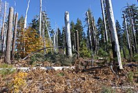
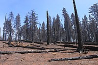
<span class="mw-page-title-main">Walker Fire (2019)</span> 2019 wildfire in Northern California

The Walker Fire was a wildfire that burned near Genesee Valley in the Plumas National Forest approximately 11 miles east of the community of Taylorsville in Plumas County, California. The blaze was reported on Wednesday, September 4, 2019 and immediately expanded in size over its several days of burning. The fire actively threatened homes from Genesee Valley to Antelope Road.

<span class="mw-page-title-main">Loyalton Fire</span> 2020 wildfire in California and Nevada

The 2020 Loyalton Fire was a large wildfire in Lassen, Plumas and Sierra counties in California and Washoe County in Nevada. After it was ignited by lightning on August 14, 2020, the fire burned 47,029 acres (19,032 ha) in the Tahoe National Forest and the Humboldt-Toiyabe National Forest before it was fully contained on August 26. The Loyalton Fire was notable for generating three fire tornadoes on August 15, necessitating first-of-their-kind warnings by the National Weather Service.

<span class="mw-page-title-main">North Complex Fire</span> 2020 wildfire in Northern California

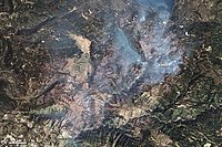
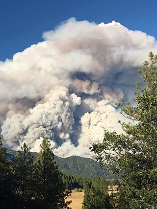
The North Complex Fire was a massive wildfire complex that burned in the Plumas National Forest in Northern California in the counties of Plumas and Butte. 21 fires were started by lightning on August 17, 2020; by September 5, all the individual fires had been put out with the exception of the Claremont and Bear Fires, which merged on that date, and the Sheep Fire, which was then designated a separate incident. On September 8, strong winds caused the Bear/Claremont Fire to explode in size, rapidly spreading to the southwest. On September 8, 2020, the towns of Berry Creek and Feather Falls were immediately evacuated at 3:15 p.m. PDT with no prior warning, By September 9, 2020, the towns of Berry Creek and Feather Falls had been leveled, with few homes left standing. The fire threatened the city of Oroville, before its westward spread was stopped. The fire killed 16 people and injured more than 100. Among the 16 fatalities was a 16-year-old boy. The complex burned an estimated 318,935 acres (129,068 ha), and was 100% contained on December 3. The fire was managed by the U.S. Forest Service in conjunction with Cal Fire, with the primary incident base in Quincy. The North Complex Fire was the sixth-largest in California's modern history, and the deadliest fire in the 2020 California wildfire season.

<span class="mw-page-title-main">Dixie Fire</span> 2021 wildfire in Northern California

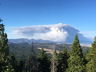
The 2021 Dixie Fire was an enormous wildfire in Butte, Plumas, Lassen, Shasta, and Tehama counties in Northern California. Named after a nearby Dixie Road, the fire began in the Feather River Canyon near Cresta Dam in Butte County on July 13, 2021, and burned 963,309 acres (389,837 ha) before it was declared 100 percent contained on October 25, 2021. It was the largest single source wildfire in recorded California history, and the second-largest wildfire overall, The fire damaged or destroyed several communities, including Greenville on August 4, Canyondam on August 5, and Warner Valley on August 12.

<span class="mw-page-title-main">Beckwourth Complex fires</span> 2021 wildfire in Northern California

The Beckwourth Complex was a wildfire complex that burned in the Plumas National Forest in Plumas and Lassen counties. The two major fires of the complex, the Dotta Fire and the Sugar Fire, started on June 30 and July 2 northeast of Beckwourth, California. Started by lightning strikes, the two fires collectively burned 105,670 acres (42,763 ha). The complex resulted in the evacuation of numerous residential areas and the closure of portions of Plumas National Forest. In the community of Doyle, California, 33 homes were destroyed.

<span class="mw-page-title-main">Mosquito Fire</span> 2022 wildfire in Northern California

The Mosquito Fire was California's largest wildfire of 2022, burning in the American River watershed in Placer and El Dorado counties in Northern California. The fire began on September 6 amid a state-wide heat wave and went on to burn 76,788 acres, primarily in the Tahoe and Eldorado National Forests, while also destroying 78 structures in the rural communities of Michigan Bluff, Foresthill, and Volcanoville. Authorities declared the fire fully contained on October 22 following several storms. The fire suppression effort cost more than $180 million, and at its peak involved more than 3,700 firefighters. The precise cause of the fire is not known, but the potential role of Pacific Gas & Electric Company (PG&E) equipment is the subject of multiple civil lawsuits and a Forest Service investigation. The Mosquito Fire was one of 7,477 total wildfires in California in 2022, which burned a combined 331,358 acres (134,096 ha).

<span class="mw-page-title-main">Kinneloa Fire</span> 1993 wildfire in Southern California

The Kinneloa Fire was a destructive wildfire in October 1993 in Los Angeles County, California. The fire burned 196 structures in the San Gabriel Mountains foothill communities of Altadena, Kinneloa Mesa, and Sierra Madre, becoming the 12th most destructive wildfire in recorded California history at the time and to this day one of the most destructive wildfires in Los Angeles County history. The fire resulted in one fatality and a multitude of minor injuries: one person died of pneumonia complicated by smoke inhalation, and two indirect deaths resulted from debris flows in the burn area more than four months later.

<span class="mw-page-title-main">Frye Fire</span> 2017 wildfire in Arizona, United States

The Frye Fire was a wildfire that burned 48,443 acres (19,604 ha) in Graham County, Arizona, United States, from June 7 to September 1, 2017. The fire was ignited by a lightning strike on Mount Graham, within the Coronado National Forest, and spread rapidly until it was mostly contained on July 12. The Frye Fire destroyed three buildings, briefly threatened the Mount Graham International Observatory, cost $26 million to contain and suppress, and involved more than 800 firefighters. There were no fatalities, but 63 firefighters were quarantined as a result of a strep throat outbreak.

<span class="mw-page-title-main">Storrie Fire</span> 2000 wildfire in Northern California

The Storrie Fire was a sizeable wildfire in Northern California's Plumas County and the second-largest of California's 2000 wildfire season. The fire began on August 17, 2000, and was fully contained by September 9; it burned 55,261 acres in total and resulted in minimal property damage or casualties. The cost of containing the Storrie Fire amounted to $22 million.

<span class="mw-page-title-main">Reading Fire</span> 2012 wildfire in Northern California

The 2012 Reading Fire was a large wildfire in Lassen Volcanic National Park and the Lassen National Forest in Northern California. Ignited by a lightning strike on July 23, the fire was managed for ecological benefits by park officials until shifts in the weather caused the fire to jump its intended control lines. The Reading Fire ultimately burned 28,079 acres, partially outside the borders of the park, before it was fully contained on August 22, 2012.

<span class="mw-page-title-main">Humboldt Wagon Road</span> Historical wagon road in California

The Humboldt Wagon Road, or the Humboldt Road, was a freight wagon road in northern California. Constructed in the 1860s, it connected Chico, near the Sacramento River, with Susanville, near Honey Lake, east of the Sierra Nevada crest. From there, extensions continued to the Humboldt silver mines in Nevada and the Owyhee Mines near Silver City, Idaho. The road was surveyed and financed by prominent settler John Bidwell and carried passengers, mail, and freight between logging and ranching communities of northeastern California. It also contributed to the settlement of the region and the displacement of the native Maidu population. Portions of the Humboldt Road are now followed by California State Route 32 and California State Route 36.

References

  1. "Chips Fire: Incident Overview". InciWeb. September 18, 2012. Archived from the original on September 25, 2013. Retrieved October 18, 2023.
  2. 1 2 3 "Chips Fire Incident Report". California Department of Forestry and Fire Protection. August 31, 2012. Archived from the original on June 25, 2021. Retrieved January 23, 2023.
  3. 1 2 "6:30 p.m. update: Chips Fire explodes; Highway 70 lane closure expanded". Chico Enterprise-Record . August 1, 2012. Archived from the original on January 23, 2023. Retrieved January 23, 2023.
  4. 1 2 3 4 5 6 7 Fites-Kaufman, Josephine A.; Ewell, Carol M.; Bauer, Ryan K. (November 20, 2012). The 2012 Chips Fire, California: A Case Study of Fire Behavior (PDF) (Report). USDA Forest Service Fire Behavior Assessment Team. Archived (PDF) from the original on January 23, 2023. Retrieved February 6, 2023 via Fire Research and Management Exchange System.
  5. "California Wildfire History Map". CapRadio . NPR. Archived from the original on January 17, 2023. Retrieved January 17, 2023.
  6. "Dixie Fire Update: Summer & Fall 2022". PlumasCounty.org. September 19, 2022. Archived from the original on January 17, 2023. Retrieved January 17, 2023.
  7. "Feather River Scenic Byway-Feather River Canyon". Sierra Nevada Geotourism. Archived from the original on January 17, 2023. Retrieved January 17, 2023.
  8. "The Feather River Canyon". PlumasCounty.org. Archived from the original on January 17, 2023. Retrieved January 17, 2023.
  9. 1 2 3 4 5 6 7 8 9 10 11 Plumas National Forest, United States Forest Service (June 2013). Chips Fire Review (PDF) (Report). Wildland Fire Lessons Learned Center. Archived from the original (PDF) on January 23, 2023. Retrieved January 23, 2023.
  10. "Chips Fire contained, but still burning vegetation". Chico Enterprise-Record . September 4, 2012. Archived from the original on January 23, 2023. Retrieved January 23, 2023.
  11. "Flight restriction lifted from Chips Fire area in Lake Almanor". Chico Enterprise-Record . September 9, 2012. Archived from the original on January 23, 2023. Retrieved January 23, 2023.
  12. Pearson, Laurie L. "Baby Bobcat "Chips" Rescued From Chips Fire". U.S. Department of Agriculture. Archived from the original on January 23, 2023. Retrieved January 27, 2023.
  13. "Chips the bobcat released back into wilderness". Chico Enterprise-Record . EUREKA TIMES-STANDARD. April 23, 2013. Archived from the original on January 23, 2023. Retrieved January 27, 2023.
  14. USDA: Forest Service - Pacific Southwest Region, Plumas National Forest (August 20, 2012). Chips Fire: Hazard Tree Felling Accident - Facilitated Learning Analysis (PDF) (Report). Wildland Fire Lessons Learned Center. Archived from the original on February 7, 2023. Retrieved February 7, 2023.
  15. "2012 Wildfire Activity Statistics" (PDF). California Department of Forestry and Fire Protection. Archived (PDF) from the original on September 5, 2023. Retrieved October 17, 2023.
  16. Cooper, Lon (July 29, 2012). "Chips Fire closes PCT at Belden". pcta.org. Pacific Crest Trail Association. Archived from the original on August 12, 2020. Retrieved October 17, 2023.
  17. Cooper, Lon (September 20, 2012). "PCT 2012 Fire Report". pcta.org. Pacific Crest Trail Association. Archived from the original on November 28, 2022. Retrieved October 17, 2023.
  18. Little, Jane Braxton (November 24, 2012). "PG&E post-fire logging criticized". The Sacramento Bee . pp.  B1, B4 (archived February 24, 2023). Archived from the original on February 24, 2023. Retrieved February 24, 2023 via Newspapers.com.