
The Zaca Fire was a wildfire in the San Rafael Mountains, northeast of the Santa Ynez Valley in Santa Barbara County, California. It was the single largest wildfire of the 2007 California wildfire season. The fire started on July 4, 2007, and by August 31, it had burned over 240,207 acres (972.083 km2), making it California's second largest fire in recorded history at that time after the Cedar Fire of 2003. As of 2023, it is California's 12th-largest recorded fire in modern history. The fire was contained on September 4, 2007, with the fire being brought under control on October 29, 2007.
The Jesusita Fire was a wildfire that started on May 5, 2009, in the hills of Santa Barbara, California in the western United States. By the time the fire was contained on May 18 it had burned 8,733 acres (35.34 km2), destroyed 80 homes and damaged 15 more before being 100% contained. The cause of the fire was ultimately traced to local contractors who had left gas cans and hot equipment unattended in dry brush after clearing part of the Jesusita Trail using a weed wacker without any permits or the permission of the landowner.

The 2009 California wildfires were a series of 9,159 wildfires that were active in the US state of California, during the year 2009. The fires burned more than 422,147 acres of land from early February through late November, due to Red Flag conditions, destroying hundreds of structures, injuring 134 people, and killing four. The wildfires also caused at least US$134.48 million in damage. Although the fires burned many different regions of California in August, the month was especially notable for several very large fires which burned in Southern California, despite being outside of the normal fire season for that region.

2014 saw several notable wildfires igniting in California, especially during the month of May, when multiple fires were ablaze concurrently in Southern California, and during September, when several massive wildfires were burning in Northern California. In the context of the 2012–13 North American drought, as well as powerful Santa Ana winds, weather conditions were ideal for wildfires. A total of 7,865 wildfires ignited throughout the year, which burned at least 625,540 acres (2,531.5 km2) of land. The wildfires caused a total of 146 injuries and 2 fatalities, in addition to causing at least $204.05 million in damage.
The May 2014 San Diego County wildfires were a swarm of 20 wildfires that erupted during May 2014, in San Diego County, California, during severe Santa Ana Wind conditions, historic drought conditions, and a heat wave. The main event during mid-May was preceded by a precursor fire that ignited on May 5. The Bernardo Fire has been declared accidental, and officials believe the Cocos Fire was intentionally set. The causes of the other fires are still under investigation by multiple agencies, and a joint task force was formed to coordinate the investigations and facilitate communications. Six injuries and one fire-related fatality were reported.
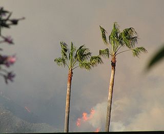
The Sherpa Fire was a wildfire that burned in the Santa Ynez Mountains along the Gaviota Coast in the southwestern part of Santa Barbara County, California in June 2016. In a matter of hours the fire spread to over 1,400 acres (570 ha) as the fire was propelled by downslope sundowner winds. This offshore northerly wind contrasts with the more typical onshore flow and sent the fire down the canyons towards the ocean with gusts of over 35 miles per hour (56 km/h). The wildfire resulted in evacuations at two state beach campgrounds and some residences together with intermittent interruption of traffic on a state transportation route.
The Rey Fire was a wildfire that burned in the area southeast of Lake Cachuma in the range above the Santa Ynez River, Santa Barbara County, California, in 2016. By the time the fire was contained, it had burned 32,606 acres (131.95 km2).
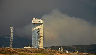
The Canyon Fire was a wildfire that burned on Vandenberg Space Force Base in Santa Barbara County, California during September 2016. By the time the fire was contained on September 24, it had burned 12,742 acres (51.6 km2) of land. Due to the nature of the activities that take place on the Base, there were a number of unique challenges posed during the fire including the presence of potentially hazardous materials.

The Whittier Fire was a wildfire in the Santa Ynez Mountains, south of Lake Cachuma, along Highway 154 in Santa Barbara County, California in the United States. The fire was reported on July 8, 2017, at 1:43 pm. Upon containment on July 28, the fire had burned a total of 18,430 acres (75 km2) and destroyed 16 homes.
The Rye Fire was a wildfire that burned in Santa Clarita, California, in the United States, and one of multiple wildfires that broke out across Southern California in December 2017. The fire threatened over 5,000 structures, including Six Flags Magic Mountain, threatened the city of Santa Clarita and impacted traffic on Interstate 5. The Rye Fire burned a total of 6,049 acres (24.48 km2), before it was fully contained on December 12. The fire destroyed six buildings, including minor structures located at the Peter J. Pitchess Detention Center.

A series of 29 wildfires ignited across Southern California in December 2017. Six of the fires became significant wildfires, and led to widespread evacuations and property losses. The wildfires burned over 307,900 acres (1,246 km2), and caused traffic disruptions, school closures, hazardous air conditions, and power outages; over 230,000 people were forced to evacuate. The largest of the wildfires was the Thomas Fire, which grew to 281,893 acres (1,140.78 km2), and became the largest wildfire in modern California history, until it was surpassed by the Ranch Fire in the Mendocino Complex, in the following year.

The Pawnee Fire was a large wildfire that burned in Spring Valley in Lake County, California, in the United States. The fire started on June 23, 2018, and quickly expanded overnight, destroying 12 structures, and causing the evacuation of the entire Spring Valley area. It destroyed 22 structures, damaged six structures, and burned a total of 15,185 acres (61 km2) before it was fully contained on July 8, 2018. A Cal Fire investigation determined in April 2019 the cause of the fire was target shooting.

The County Fire was a wildfire east of Lake Berryessa in Yolo County and Napa County, California in the United States. The fire, first reported on June 30, 2018, in Rumsey Canyon in the community of Guinda, and was contained on July 17, 2018 after burning 90,288 acres. The fire caused mandatory evacuations along Highway 128, County Road 23, and areas around Lake Berryessa, including Monticello Dam. The fire destroyed 20 structures, damaged three, and caused one injury. The fire was started by an improperly installed electric fence for livestock.

The Cranston Fire was a wildfire that burned in southwest Riverside County, California, in the United States. The fire was started on July 25, 2018, by Brandon M. McGlover, in an act of arson. The fire burned a total of 13,139 acres (53 km2), before it was fully contained on August 10. The Cranston Fire impacted the communities of Idyllwild, Mountain Center, and Anza as well as recreational activities in the Lake Hemet area, San Bernardino National Forest and Mount San Jacinto State Park. Over 7,000 people were evacuated due to the Cranston Fire. These communities also went without power for 11 days in 100° temperatures.
The Mendocino Complex Fire was a large complex of wildfires that burned in northern California for more than three months in 2018. It consisted of two wildfires, the River Fire and Ranch Fire, which burned in Mendocino, Lake, Colusa, and Glenn Counties in the U.S. State of California, with the Ranch Fire being California's single-largest recorded wildfire at the time until the August Complex fire in 2020. The Ranch Fire burned eight miles northeast of Ukiah, and the River Fire burned six miles north of Hopland, to the south of the larger Ranch Fire. First reported on July 27, 2018, both fires burned a combined total of 459,123 acres (1,858 km2), before they were collectively 100% contained on September 18, though hotspots persisted until the complex was fully brought under control on January 4, 2019. The Ranch Fire alone burned 410,203 acres (1,660 km2), making it the largest wildfire in modern California history at the time until the August Complex fire that occurred in 2020. The Ranch Fire also surpassed the size of the 315,577-acre Rush Fire, which burned across California and Nevada, as well as the Santiago Canyon Fire of 1889, which was previously believed to have been California's all-time largest wildfire.

The 2019 California wildfire season was a series of wildfires that burned across the U.S. state of California as part of the 2019 wildfire season. By the end of the year, according to Cal Fire and the US Forest Service, 7,860 fires were recorded, totaling an estimated of 259,823 acres of burned land. These fires caused 22 injuries, 3 fatalities, and damaged or destroyed 732 structures. The 2019 California fire season was less active than that of the two previous years, which set records for acreage, destructiveness, and deaths.

The Butts Fire was a wildfire in Napa County north of Pope Valley, and 10 miles west of Lake Berryessa, California in the United States. The fire was reported on July 1, 2014 and was contained on July 10, after burning an estimated 4,300 acres (17 km2). The fire, dubbed after Butts Canyon in the Pope Valley area, threatened more than 300 homes at its peak, and lead to the closure of Butts Canyon Road. The cause of the Butts fire remains under investigation. The fire also subsequently destroyed 2 homes, 7 outbuildings and killed 2 civilians. At the fires peak, 1,682 fire personnel, 101 fire engines, 60 fire crews, 10 bulldozers, nine helicopters, and four air tankers were battling the inferno.

The Crews Fire was a wildfire that burned east of the city of Gilroy in Santa Clara County, California, in the United States. The fire started on July 5, 2020. It burned 5,513 acres (2,231 ha) and was extinguished on July 13, 2020. Burning approximately three miles east of Highway 101, the fire caused the evacuation approximately 20 homes and 70 residents. One structure was destroyed, one was damaged, and one firefighter was injured. It threatened 30 structures and farm and ranch lands in southeast Gilroy in the San Juan Valley. Mandatory evacuations were ordered on July 5, and they were lifted on July 8.

The Mineral Fire was a wildfire that burned in Coalinga Mineral Springs, west of Coalinga in Fresno, California in the United States. The fire was first reported on July 13, 2020 and burned an estimated 29,667 acres (12,006 ha) and before being fully contained on July 26. The fire threatened the communities of Los Gatos Creek Road from Indian Springs to Union Carbide Road and Bingham Springs. It resulted in the mandatory evacuations of Los Gatos Creek Road and Bingham Springs and led to the complete closure of State Route 198 from Firestone Ave. to the Monterey County Line. They were subsequently lifted on July 20.

The Border 32 Fire was a destructive wildfire that burned amid the 2022 California wildfire season, in the Barrett Junction area along Highway 94 due north of the United States-Mexican border in San Diego County, California during a statewide heatwave. The fire started on August 31, 2022, and proceeded to destroy ten structures and eventually grow to 4,456 acres (1,803 ha) within the rugged chaparral-dense hillsides throughout the area.


