Monument Fire

Last updated
Monument Fire
Monument Fire - 08-01-21.jpg
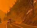
The Monument Fire on August 1, 2021
Date(s)
  • July 30, 2021 (2021-07-30)
Location Big Bar, Shasta-Trinity National Forest, Trinity County, California, United States
Coordinates 40°45′07″N123°20′13″W / 40.752°N 123.337°W / 40.752; -123.337
Statistics [1] [2]
Burned area223,124 acres (90,295 ha)
Impacts
Structures destroyed3 homes
1 commercial
Ignition
CauseLightning strike
Map
USA California location map.svg
FireIcon.svg
Location in California

The Monument Fire (formerly known as the Panther Fire [3] ) was a wildfire west of Big Bar in Shasta-Trinity National Forest, Trinity County, California in the United States. The fire, which was started by a lightning strike, was first reported on July 30, 2021. The communities of Big Flat, Big Bar, Del Loma, and Cedar Flat are evacuated. Highway 299 is closed in the area. The fire has destroyed four structures, including three homes. As of the evening of October 27, the fire has burned 223,124 acres (90,295 ha) and is fully contained. [4]

Contents

Progression

July

The Monument Fire was first reported burning west of Big Bar in Shasta-Trinity National Forest around 6:00 PM on July 30, 2021. [1] [5] The cause of the fire was a lightning strike. [1] The fire was first called the Panther Fire. Its name was changed by August 1 to the Monument Fire. [3]

August

By August 1, the fire had burned over 1,000 acres (405 ha). [3] Evacuation warnings were put in place for Del Loma and Big Bar and a portion of Highway 299 was closed three hours due to the fire's growth. [3] [6]

The Monument Fire began burning in the fire scar of the 2008 Cedar Fire on August 2. Mandatory evacuations were put in place for Big Bar, Del Loma, and Cedar Flat on August 2. [7] Warnings were also put in place for Burnt Ranch. An evacuation center as opened in Weaverville and Willow Creek, California. [8] Overnight into August 4, four spot fires were established on the north side of the Trinity River and Highway 299. A rock slide blocked parts of Highway 299 near Snyder Bar. This caused a delay in resources accessing the west side of the fire. Phone and internet was also reported out in Big Bar. [5] Power lines were de-energized by PG&E for Big Bar on the morning of August 5 due to concerns about the fire's proximity to power infrastructure. [9] Big Bar was finally placed under mandatory evacuation in the early evening. [10] Additional evacuation warnings were also put in place for Helena, Junction City, Coopers Bar, Red Hill and Canyon Creek. [2] In addition to burning in the Cedar Fire scar, the Monument Fire began burning in the scars of the 2012 Flat Fire and the 2015 River Complex. [10] By August 7, it was confirmed that at least four structures had burned in Big Flat, specifically one commercial and three homes. [2] That same day, the North Coast Unified Air Quality Management District announced an air quality smoke advisory for Weaverville, describing the air quality as "hazardous" and "worse than anticipated." [11]

As of the morning of August 7, the fire has burned 44,317 acres (17,934 ha) and is not contained. [1]

The Monument Fire burning along Highway 299 near Big Bar, which was evacuated on August 2. Monument Fire Evac 080121.jpg
The Monument Fire burning along Highway 299 near Big Bar, which was evacuated on August 2.

Effects

Recreation

The Monument Fire, like many fires in the area during the 2021 fire season, has impacted recreational activities and tourism in the area. Rafting activities were halted by many companies in the area due to fire concerns and smoke. [12] Additionally, the Forest Service closed a portion of Shasta-Trinity National Forest through October 31, 2021, due to the fire. [13]

Infrastructure

In Big Flat, one business and three homes were destroyed by the fire. [2]

The fire impacted phone and internet access in the Big Bar area, disconnecting both, starting August 4. [5] Power lines were de-energized in Big Bar on August 5 due to the fire's proximity to PG&E infrastructure. [9]

Environment

Air quality throughout Northern California was impacted by the Monument Fire, both in the local fire area, and as far as San Francisco. On August 7, an air quality advisory was put in place for Weaverville, California, due to hazardous air quality. The air quality index was reported as 301 or higher in the community. [11] Smoke from the Monument Fire impacted air quality in the Sacramento Valley and San Francisco Bay Area. [2]

Related Research Articles

<span class="mw-page-title-main">Helena Fire</span> 2017 wildfire in Northern California

The Helena Fire was a wildfire that burned in Trinity Alps Wilderness and west of the town of Weaverville, Trinity County, California in the United States. The fire had burned 21,846 acres (88 km2), and destroyed 72 homes. The fire merged with the nearby Fork Fire. The Helena Fire was fully extinguished on November 15, after reaching 21,846 acres (88 km2). The cause of the fire was a tree falling into a power line. The fire threatened the communities of Weaverville and Junction City and impacted recreational activities in the area.

<span class="mw-page-title-main">Chetco Bar Fire</span> 2017 wildfire in the U.S. state of Oregon

The Chetco Bar Fire was a wildfire in the Kalmiopsis Wilderness, Oregon, United States. The fire, which was caused by a lightning strike and first reported on July 12, 2017. It burned 191,125 acres (773 km2) as of November 4, when it was declared 100% contained. The Chetco Bar Fire area is subject to warm, dry winds known as the Brookings effect, driven by high pressure over the Great Basin. The fire re-burned portions of the 2002 Biscuit Fire and the 1987 Silver Fire. The fire directly impacted communities surrounding it, causing mandatory evacuations.

<span class="mw-page-title-main">Pier Fire</span> 2017 wildfire in Central California

The Pier Fire was a wildfire that burned near Springville and in the Sequoia National Forest, in California in the United States. The fire was reported on August 29, 2017. The cause of the fire is under investigation, but is believed to be human-caused. The fire was completely extinguished on November 29, after it had burned 36,556 acres (148 km2). The fire threatened old growth sequoia trees, the Tule River Indian Reservation, and many small communities in the area.

<span class="mw-page-title-main">Railroad Fire</span> 2017 wildfire in Central California

The Railroad Fire was a wildfire that burned in between the communities of Sugar Pine and Fish Camp in the Sierra National Forest in California, United States. The fire was reported on August 29, 2017 and burned 12,407 acres (50 km2) before it was fully contained on October 24. It occurred during the historic 2011–2017 California drought. The cause of the fire remains unknown.

<span class="mw-page-title-main">Lions Fire</span> 2018 wildfire in California

The Lions Fire was a wildfire in the Ansel Adams Wilderness in Inyo National Forest and the Sierra National Forest in California in the United States. The fire was started by a lightning strike and first reported on June 11, 2018. The fire impacted recreational activities in both national forests, as well as access to Devils Postpile National Monument. The Lions Fire burned a total of 13,347 acres (54 km2), before burning out on October 1.

<span class="mw-page-title-main">Valley Fire (2018)</span> 2018 wildfire in Southern California

The Valley Fire was a wildfire that burned near the community of Forest Falls in San Bernardino National Forest, including the San Gorgonio Wilderness in California, United States. The fire was reported on July 6, one of a handful of brush fires that started in the area due to high temperatures and dry conditions. The Valley Fire burned 1,350 acres (5 km2) before it was fully contained on October 22. The fire impacted traffic on Highway 38 due to road closures and has caused evacuations of Forest Falls.

<span class="mw-page-title-main">Ferguson Fire</span> 2018 wildfire in Central California

The Ferguson Fire was a major wildfire in the Sierra National Forest, Stanislaus National Forest and Yosemite National Park in California in the United States. The fire was reported on July 13, 2018, burning 96,901 acres (392 km2), before it was 100% contained on August 19, 2018. Interior areas of the fire continued to smolder and burn until September 19, 2018, when InciWeb declared the fire to be inactive. The Ferguson Fire was caused by the superheated fragments of a faulty vehicle catalytic converter igniting vegetation. The fire, which burned mostly in inaccessible wildland areas of the national forest, impacted recreational activities in the area, including in Yosemite National Park, where Yosemite Valley and Wawona were closed. The Ferguson Fire caused at least $171.2 million in damages, with a suppression cost of $118.5 million and economic losses measuring $52.7 million. Two firefighters were killed and nineteen others were injured in the fire.

<span class="mw-page-title-main">Mangum Fire</span> 2020 Arizona wildfire

The Mangum Fire was a wildfire in Kaibab National Forest in Arizona in the United States. The fire, which started on June 8, 2020 approximately 16 miles north of the North Rim of Grand Canyon National Park, burned a total of 71,450 acres (28,915 ha). The fire threatened the community of Jacob Lake, Arizona, resulting in its evacuation. Select highways were closed, including Highway 67, which resulted in closure of the North Rim of the Grand Canyon. Additionally, areas of the Paria Canyon-Vermilion Cliffs Wilderness were inaccessible due to closures. Four buildings were destroyed, including two historic cabins. The exact cause of the fire remains under investigation, however, fire officials have confirmed it was human caused.

<span class="mw-page-title-main">Numbers Fire</span>

The Numbers Fire was a wildfire that burned in the Pine Nut Mountains, near Gardnerville, Nevada, in the United States. The fire was reported on July 6, 2020, and burned 18,342 acres (7,423 ha). It was contained on July 14, 2020. The fire threatened the communities of Ruhenstroth, Pine View Estates and Bodie Flats, totaling approximately 1,000 homes. It resulted in the mandatory evacuations of Pine View Estates and Bodie Flats and the closure of a 15-mile stretch of Highway 395. Forty structures were destroyed, including three homes. The fire was started by a truck with mechanical issues which discharged particles which ignited the fire.

<span class="mw-page-title-main">Lake Fire (2020)</span> 2020 wildfire in Southern California

The Lake Fire was a wildfire that burned during the 2020 California wildfire season in the Angeles National Forest in Los Angeles County in the state of California in the United States. The fire, which was first reported on August 12, 2020, burned 31,089 acres (12,581 ha) near Lake Hughes. It was fully contained on September 28. The cause of the fire remains unknown. The fire has damaged 3 structures, destroyed 12 structures and 21 outbuildings, and injured 4 firefighters.

<span class="mw-page-title-main">Red Salmon Complex fire</span> 2020 wildfire in Northern California

The Red Salmon Complex was a wildfire that burned 144,698 acres (58,557 ha) in Humboldt, Trinity, and Siskiyou County in Northern California during the 2020 California wildfire season. On July 27, lightning strikes in the Trinity Alps Wilderness started two fires, the Salmon Fire and the Red Fire, which eventually merged. As the fire grew, hazardous smoke levels surrounded Forks of Salmon, Orleans, Yreka, and Weed.

The 2021 Washington wildfire season officially began in March 2021. By late April, all of Eastern Washington had been classified by the United States Drought Monitor as "abnormally dry" with moderate to severe drought conditions. The state had more than 630 wildfires by the first week of July, on par with the state's record 2015 wildfire season.

<span class="mw-page-title-main">Salt Fire (2021)</span> 2021 wildfire in Northern California

The Salt Fire was a wildfire that burned 12,660 acres (5,123 ha) in the Lakehead area north of Shasta Lake in Shasta County, California in the United States during the 2021 California wildfire season. The fire was first reported on Wednesday, June 30, 2021, and it was fully contained on July 19, 2021. The fire destroyed forty-one structures, including twenty-seven residences and fourteen outbuildings, and damaged four additional outbuildings. Although the cause remains under investigation, officials from the Shasta–Trinity National Forest believe that the fire was likely sparked by hot material that fell from a vehicle on Interstate 5 and landed in dry brush next to the freeway.

<span class="mw-page-title-main">Tamarack Fire</span> 2021 wildfire in California and Nevada

The Tamarack Fire was a wildfire that burned 68,637 acres (27,776 ha), primarily in the Mokelumne Wilderness in Alpine County, California, Douglas County, Nevada and Lyon County, Nevada, as part of the 2021 California wildfire season.

<span class="mw-page-title-main">Tennant Fire</span> 2021 wildfire in Northern California

The Tennant Fire was a wildfire that burned in the Klamath National Forest in Siskiyou County, California, in the United States as part of the 2021 California wildfire season. The fire was first reported just east of Highway 97, three miles northwest of Bray, California on June 28, 2021. The fire was contained on July 12, 2021. The fire burned 10,580 acres (4,282 ha), destroyed five structures, and caused evacuations in Macdoel, California. The cause remains under investigation. The Tennant Fire was one of three fires burning at the same time in the Lake Shasta region, the others being the Lava Fire and the Salt Fire.

<span class="mw-page-title-main">McFarland Fire</span> 2021 wildfire in Northern California

The McFarland Fire was a wildfire that burned in the Shasta-Trinity National Forest north of Wildwood in Trinity County, Shasta County, and Tehama County, California in the United States. Started by a lightning strike, the fire was first reported on July 29, 2021 on McFarland Ridge south of Highway 36. As of September 16, 2021, the fire had burned 122,653 acres (49,636 ha) and destroyed 46 structures.

<span class="mw-page-title-main">Beckwourth Complex fires</span> 2021 wildfire in Northern California

The Beckwourth Complex was a wildfire complex that burned in the Plumas National Forest in Plumas and Lassen counties. The two major fires of the complex, the Dotta Fire and the Sugar Fire, started on June 30 and July 2 northeast of Beckwourth, California. Started by lightning strikes, the two fires collectively burned 105,670 acres (42,763 ha). The complex resulted in the evacuation of numerous residential areas and the closure of portions of Plumas National Forest. In the community of Doyle, California, 33 homes were destroyed.

<span class="mw-page-title-main">Antelope Fire</span> 2021 wildfire in California

The Antelope Fire was a wildfire that burned in the Klamath National Forest, the Modoc National Forest, the Shasta-Trinity National Forest, and in Lava Beds National Monument in Siskiyou County, California, in the United States. The fire was started by a lightning strike and was first reported on August 1, 2021. As of October 15, the fire had burned 145,632 acres (58,935 ha).

<span class="mw-page-title-main">River Complex 2021 fires</span> 2021 wildfire in Northern California

The River Complex 2021 was a wildfire complex burning in Klamath National Forest in Siskiyou County, California in the United States. The complex comprises over 20 wildfires that started as a result of lightning strikes during a series of thunderstorms in late July 2021. As of 25 October 2021, the fire had burned a total of 199,343 acres (80,671 ha) and became 100% contained. The largest fires in the complex were the Haypress–Summer Fire and the Cronan Fire.

<span class="mw-page-title-main">2022 Washington wildfires</span> Wildfire season

The 2022 Washington wildfire season officially began in March 2022. As of August 4, 2022, there have been four large wildfires that have burned 30,800 acres (12,500 ha) across the US state of Washington. This season started quieter than normal due to unusually colder weather that kept Eastern and Southeastern Washington burning index's largely below normal into July. As of October 2022, a total of 140,000 acres (57,000 ha) of land in the state was burned – the fewest number of acres burned since 2012.

References

PD-icon.svg This article incorporates public domain material from websites or documents of the United States Forest Service .

  1. 1 2 3 4 "Monument Fire Update for August 4, 2021". InciWeb. Archived from the original on 5 August 2021. Retrieved 5 August 2021.
  2. 1 2 3 4 5 Gardner, Ashley (6 August 2021). "Monument Fire grows to more than 36,000 acres as threat to communities remains". KRCR. Archived from the original on 6 August 2021. Retrieved 7 August 2021.
  3. 1 2 3 4 Spurlock, Aaron (1 August 2021). "Fire in Trinity County prompts evacuation warnings". KRCR. Archived from the original on 5 August 2021. Retrieved 5 August 2021.
  4. "Monument Fire Information - InciWeb the Incident Information System". inciweb.nwcg.gov. Archived from the original on 2021-08-24. Retrieved 2021-08-25.
  5. 1 2 3 "Monument Fire Update for August 4, 2021". InciWeb. Archived from the original on 5 August 2021. Retrieved 5 August 2021.
  6. Kemp, Kym (1 August 2021). "[UPDATE 7:35 p.m.: REOPENED] Hwy 299 Closed at Big Bar Due to the Monument Fire". Redheaded Blackbelt. Archived from the original on 5 August 2021. Retrieved 5 August 2021.
  7. Leeds, Darren (2 August 2021). "Monument Fire has burned more than 4,000 acres". KRCR. Archived from the original on 5 August 2021. Retrieved 5 August 2021.
  8. "Evacuation UPDATE 8/3/21". InciWeb. Retrieved 5 August 2021.
  9. 1 2 "Monument Fire Update for August 5, 2021". InciWeb. Retrieved 7 August 2021.
  10. 1 2 "PG&E to de-energize lines in the Big Bar Area". InciWeb. Retrieved 5 August 2021.
  11. 1 2 Air Quality Smoke Advisory Archived 2021-08-07 at the Wayback Machine , 7 August 2021
  12. Kanne, Ryan (3 August 2021). "Junction City locals wait for whatever the Monument Fire brings". KHSL News. Archived from the original on 4 August 2021. Retrieved 5 August 2021.
  13. "Shasta-Trinity National Forest, Forest Order No. 14-21-21, Monument Fire Closure" (PDF). Archived (PDF) from the original on 2021-08-07. Retrieved 2021-08-07.