
Contra Costa County is a county located in the U.S. state of California, in the East Bay of the San Francisco Bay Area. As of the 2020 United States Census, the population was 1,165,927. The county seat is Martinez. It occupies the northern portion of the East Bay region of the San Francisco Bay Area and is primarily suburban. The county's name refers to its position on the other side of the bay from San Francisco. Contra Costa County is included in the San Francisco–Oakland–Berkeley, CA Metropolitan Statistical Area.
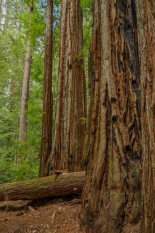
Big Basin Redwoods State Park is a state park in the U.S. state of California, located in Santa Cruz County, about 36 km (22 mi) northwest of Santa Cruz. The park contains almost all of the Waddell Creek watershed, which was formed by the seismic uplift of its rim, and the erosion of its center by the many streams in its bowl-shaped depression.

The Diablo Range is a mountain range in the California Coast Ranges subdivision of the Pacific Coast Ranges in northern California, United States. It stretches from the eastern San Francisco Bay Area at its northern end to the Salinas Valley area at its southern end.
California's 10th congressional district is a congressional district in the U.S. state of California. Currently, the 10th district encompasses parts of the eastern San Francisco Bay Area. It is currently represented by Democrat Mark DeSaulnier.
The community of San Antonio Valley, also called San Antonio or San Antone, is located along the Diablo Range in eastern Santa Clara County, California. The locale is bordered by Alameda County to the north and Stanislaus County to the east. The sparsely populated area is located at the junction of San Antonio Valley Road, Mines Road, and Del Puerto Canyon Road. San Antonio Valley Road and Del Puerto Canyon Road are legislatively part of California State Route 130 but have not been adopted by CalTrans.
The California Department of Forestry and Fire Protection is the fire department of the California Natural Resources Agency in the U.S. state of California. It is responsible for fire protection in various areas under state responsibility totaling 31 million acres, as well as the administration of the state's private and public forests. In addition, the department provides varied emergency services in 36 of the state's 58 counties via contracts with local governments. The department's current director is Joe Tyler, who was appointed March 4, 2022, by Governor of California Gavin Newsom.
California's State Assembly districts are numbered 1st through 80th, generally in north-to-south order.
The East Bay Hills is a mountain range in the California Coast Ranges subdivision of the Pacific Coast Ranges in northern California, United States. They are the first range of mountains east of San Francisco Bay and stretch from the Carquinez Strait in the north to Alameda Creek/Highway 84 in the south, crossing both Contra Costa and Alameda Counties. Although not formally recognized by United States Geological Survey (USGS) Geographic Names Information System, the East Bay Hills is included as part of the Diablo Range in its list of multiple GPS coordinates for the latter.

9,159 wildfires were active in the US state of California during 2009. The fires burned more than 422,147 acres of land from early February through late November, due to Red Flag conditions, destroying hundreds of structures, injuring 134 people, and killing four. The wildfires also caused at least US$134.48 million in damage. Although the fires burned many different regions of California in August, the month was especially notable for several very large fires which burned in Southern California, despite being outside of the normal fire season for that region.

Diablo Grande is a census-designated place (CDP) in Stanislaus County, California. It is a gated bedroom community nestled in the Diablo Range, whence it gets its name. Diablo Grande sits at an elevation of 1,535 feet (468 m). It is about 9 miles (14 km) southwest of Patterson. The 2010 United States census reported Diablo Grande's population was 826. The 2018 estimated population was 1,200.

The Tubbs Fire was a wildfire in Northern California during October 2017. At the time, the Tubbs Fire was the most destructive wildfire in California history, burning parts of Napa, Sonoma, and Lake counties, inflicting its greatest losses in the city of Santa Rosa. Its destructiveness was surpassed only a year later by the Camp Fire of 2018. The Tubbs Fire was one of more than a dozen large fires that broke out in early October 2017, which were simultaneously burning in eight Northern California counties, in what was called the "Northern California firestorm". By the time of its containment on October 31, the fire was estimated to have burned 36,810 acres (149 km2); at least 22 people were believed to have been killed in Sonoma County by the fire.
The Kincade Fire was a wildfire that burned in Sonoma County, California in the United States. The fire started northeast of Geyserville in The Geysers at 9:24 p.m. on October 23, 2019, and subsequently burned 77,758 acres (31,468 ha) until the fire was fully contained on November 6, 2019. The fire threatened over 90,000 structures and caused widespread evacuations throughout Sonoma County, including the communities of Geyserville, Healdsburg, Windsor, and Santa Rosa. The majority of Sonoma County and parts of Lake County were under evacuation warnings and orders. Lake county only had one evacuation order and that was the town of Middletown. The fire was the largest of the 2019 California wildfire season, and also the largest wildfire recorded in Sonoma County at the time before being surpassed by the LNU Lightning Complex fires in 2020.

2020 was a record-setting year for wildfires in California. Over the course of the year, 8,648 fires burned 4,304,379 acres (1,741,920 ha), more than four percent of the state's roughly 100 million acres of land, making 2020 the largest wildfire season recorded in California's modern history. However, it is roughly equivalent to the pre-1800 levels which averaged around 4.4 million acres yearly and up to 12 million in peak years. California's August Complex fire has been described as the first "gigafire", burning over 1 million acres across seven counties, an area larger than the state of Rhode Island. The fires destroyed over 10,000 structures and cost over $12.079 billion in damages, including over $10 billion in property damage and $2.079 billion in fire suppression costs. The intensity of the fire season has been attributed to a combination of more than a century of poor forest management and higher temperatures resulting from climate change.

The Crews Fire was a wildfire that burned east of the city of Gilroy in Santa Clara County, California, in the United States. The fire started on July 5, 2020. It burned 5,513 acres (2,231 ha) and was extinguished on July 13, 2020. Burning approximately three miles east of Highway 101, the fire caused the evacuation approximately 20 homes and 70 residents. One structure was destroyed, one was damaged, and one firefighter was injured. It threatened 30 structures and farm and ranch lands in southeast Gilroy in the San Juan Valley. Mandatory evacuations were ordered on July 5, and they were lifted on July 8.

The LNU Lightning Complex fires were a large complex of wildfires that burned during the 2020 California wildfire season across much of the Wine Country area of Northern California – Lake, Napa, Sonoma, Solano, and Yolo Counties, from August 17 to October 2, 2020. The complex was composed of numerous lightning-sparked fires, most of which were small. While they ignited separately from each other, the Hennessey Fire eventually grew to merge with the Gamble, Green, Markley, Spanish, and Morgan fires, scorching 192,000 acres (777 km2) by itself, for a total burn area of 363,220 acres (1,470 km2) in the complex. The fire, which burned in the hills surrounding several large cities, such as Fairfield, Napa, and Vacaville, destroyed 1,491 structures and damaged a further 232. In all, six people were killed and another five injured. The LNU Lightning Complex is the seventh-largest wildfire in the recorded history of California.

A series of 650 wildfires ignited across Northern California in mid-August 2020, due to a siege of dry lightning from rare, massive summer thunderstorms, which were caused by an unusual combination of very hot, dry air at the surface, dry fuels, and advection of moisture from the remains of Tropical Storm Fausto northward into the Bay Area. These fires burned between 1,500,000 acres (6,100 km2) to 2,100,000 acres (8,500 km2) within a 2–3 week period. The August 2020 lightning fires included three enormous wildfires: the SCU Lightning Complex, the August Complex, and the LNU Lightning Complex. On September 10, 2020, the August Complex set a record for the single-largest wildfire in the modern history of California, reaching a total area burned of 471,185 acres (1,907 km2). On September 11, the August Complex merged with the Elkhorn Fire, another massive wildfire of 255,039 acres (1,032 km2), turning the August Complex into a monster wildfire of 746,607 acres (3,021 km2).

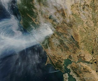
The CZU Lightning Complex fires were wildfires that burned in Northern California starting in August 2020. The fire complex consisted of fires in San Mateo and Santa Cruz counties, including fires that had previously been separately tracked as the Warnella and Waddell fires. The firefighting effort was primarily administered by the California Department of Forestry and Fire Protection.

The Western United States experienced a series of major wildfires in 2020. Severe August thunderstorms ignited numerous wildfires across California, Oregon, and Washington, followed in early September by additional ignitions across the West Coast. Fanned by strong, gusty winds and fueled by hot, dry terrains, many of the fires exploded and coalesced into record-breaking megafires, burning more than 10.2 million acres of land, mobilizing tens of thousands of firefighters, razing over ten thousand buildings, and killing at least 37 people. The fires caused over $19.884 billion in damages, including $16.5 billion in property damage and $3.384 billion in fire suppression costs. Climate change and poor forest management practices contributed to the severity of the wildfires.
In the U.S. state of California, a congestion management agency (CMA) is a county-level government agency responsible for a comprehensive transportation improvement program that reduces traffic congestion and reduces transportation-related air pollution through local land-use planning.

