The general location of the Rocky Fire in Northern California
The Rocky Fire was a large wildfire in Lake, Colusa, and Yolo counties in Northern California in 2015. The fire burned 69,438 acres (28,101 hectares) between its ignition on July 29 and its full containment on August 14. Caused by a malfunctioning water heater being used for illegal cannabis cultivation, the fire destroyed 96 structures and was the fifth largest fire of the 2015 fire season in California.
The Rocky Fire burn area largely comprised rough terrain with oak woodlands, grasslands, and chaparral,[1] and it had no prior wildfire history going back "several decades", according to the California Governor's Office of Emergency Services.[2] This absence was partly attributable to fire suppression policies that prevented wildfires from periodically reducing the build-up of vegetation.[3] Dense chaparral—more than six feet (1.8m) tall in some areas—had flourished in the meantime, providing plentiful fuel for fire growth.[4] A multiple-year drought then began in 2011. Moisture levels in chamise brush, one of the vegetation types that characterized the Rocky Fire burn area, reached near-record lows by the onset of the fire in July despite the driest months of the year typically being September and October.[3]
California's 2015 wildfire season was characterized by aggressive fires that, aided by drought conditions, remained active through the night instead of abating. By August 8, as the Rocky Fire was underway, the amount of state land burned in wildfires was more than double the five-year average.[5] The Rocky Fire was one of 52 wildfires to exceed 40,000 acres (16,000ha) in the United States in 2015.[6]:7 In California, 8,283 wildfires burned a total of 880,899 acres (356,487ha).[7]
Progression
The Rocky Fire began at a property on Morgan Valley Road, east of Clearlake in Lake County, at about 3:30p.m. PDT on Wednesday, July 29, when a gas-powered water heater in an outbuilding caught fire and set nearby vegetation alight.[8][9] Firefighters were initially dispatched to the incident based on a report of a structure fire on Rocky Creek Road; a second fire was later reported on Morgan Valley Road with an unknown cause.[10] The fire was named the Rocky Fire for its proximity to Rocky Creek, which flows north of Morgan Valley Road.[11]
High temperatures and winds helped the ensuing fire spread rapidly as it entered thick brush and woodlands, advancing forward by ember spotting.[12] In several hours, the fire grew from 150 acres (61ha) to 3,000 acres (1,200ha), destroying several outbuildings and necessitating mandatory evacuation orders for about 500 people. A total of 350 firefighting personnel engaged the fire in the first day, joined by eight air tankers and eight helicopters.[11]
By the following afternoon, the fire had burned 8,300 acres (3,400ha) and had forced residents of Lower Lake and nearby roads to evacuate while pushing into the Cache Creek Wilderness and the Berryessa Snow Mountain National Monument.[12] By that night, the Rocky Fire spanned 13,500 acres (5,500ha) in area and was the largest active wildfire in Northern California.[1]
Originally confined to a rugged area bounded by California State Route 29 to the west and Route 16 to the east, the fire became much more active on Saturday, August 1.[2] Temperatures reached more than 100°F (38°C) and relative humidity levels approached zero percent. Using bulldozers, firefighters built containment lines ahead of the Rocky Fire's northern and eastern flanks.[13] Toward the end of the day, the fire's rate of spread vastly exceeded what had been predicted by computer modeling, consuming 20,000–22,000 acres (8,100–8,900ha) in a five-hour period.[14][15] A Cal Fire public information officer described the growth as "really unprecedented in recent times, or in even veterans of our department’s recollection" for a wildfire not influenced by strong winds.[16] The fire produced large pyrocumulus clouds that reached 35,000 feet (11,000m) in altitude, which had a tendency to collapse and spread the fire erratically when downdrafts reached the surface.[17]
A Cal Fire captain looks out for potential hazards during a helicopter water bucket drop on August 1
The Rocky Fire continued to burn actively that night and through the following day. Fire personnel abandoned the containment lines they had built on the northern/eastern flanks, retreating several miles further north to California State Route 20 (CA 20) and further east to California State Route 16 (CA 16). There, they conducted firing operations, burning off fuel between the highways and the fire itself so as to halt its growth in those directions. The Rocky Fire reached approximately 54,000 acres (22,000ha) in burned area with five percent containment by the end of Sunday, August 2.[13]
Satellite view of the burn scar
The Rocky Fire seen via natural color Landsat 8 satellite imagery on August 3, 2015
A simultaneous false-color composite image using short-wave infrared and near-infrared light
By Monday, August 3, fire activity was expected to calm as an incoming weather system brought temperatures down and relative humidity up.[4] In the afternoon, the Rocky Fire crossed CA 20 to the north, despite the firing operations and other preparations the previous day.[18] The fire burned up-slope in a drainage near Cache Creek, creating a large plume that—in combination with a sudden wind shift—caused ember spotting up across the highway up to one mile (1.6km) away in Long Valley. The fire then proceeded to burn through a subdivision, destroying multiple structures, as it moved north towards Indian Valley Reservoir.[17]
On Tuesday, August 4, White House Press SecretaryJosh Earnest said that President Barack Obama had been briefed on the fire by Lisa Monaco, one of his national security advisors, and that the White House would continue to monitor the situation.[17] That same day, the National Interagency Fire Center ranked the Rocky Fire as the highest-priority wildfire in the country for additional equipment and personnel.[19] By August 5, at roughly 69,600 acres (28,166ha), the Rocky Fire's burned area was more than four times that of any other active wildfire in California, though only the portion of the fire perimeter that had burned across CA 20 remained uncontained.[20]
Despite the setback, by later in the week improved weather conditions allowed firefighters to double containment of the perimeter in two days.[5] The number of personnel assigned to the Rocky Fire peaked at more than 3,500 people on August 6.[21] This included hundreds of inmates in the California Department of Corrections and Rehabilitation system, earning $1.45–$3.90 per hour plus a bonus one dollar per hour for working on a fire.[22]
The fire was declared 100 percent contained on Friday, August 14. The total area burned in the fire was calculated at 69,438 acres (28,101ha),[6] adjusted down from 69,636 acres (28,181ha) by more accurate mapping.[23] According to the National Interagency Fire Center, the cost of fighting the fire came to $46.1million at the time, or roughly equivalent to $57.9million in 2023 when adjusted for inflation.[6]:9
Cause
On August 17, 2016, California Department of Forestry and Fire Protection (Cal Fire) officials announced that the Rocky Fire had been ignited by a malfunctioning gas-powered water heater strapped to a tree and housed in an outbuilding filled with flammable liquids, associated with an illegal cannabis growing operation. A spokesperson called the arrangement "inventive" but "not very safe". Two suspects in the fire—not named by Cal Fire—fled the country before investigators could question them. The Rocky Fire was one of five wildfires related to cannabis cultivation in Northern California in 2015.[24][25]
Effects
No injuries or deaths were recorded during the Rocky Fire.[8] Ninety-six structures were destroyed, comprising 43 homes and 53 outbuildings.[24] Eight structures were damaged.[8] Most of the burned buildings were in the Morgan Valley area near the fire's origin.[20] The Rocky Fire was the third most destructive fire of the year in California, surpassed by the Valley Fire in Lake County and the Butte Fire in Amador County.[7]
The number of people under mandatory evacuation orders reached 1,480; when including voluntary evacuation warnings approximately 13,000 people were affected.[4][15][26] Some residents were forced to stay in hotels, some in the two Red Cross shelters established nearby, others in tents in parking lots.[14][15] After fire growth and suppression operations had forced their closure on August 1,[2] California State Routes 20 and 16 re-opened on Friday, August 7. Evacuations were lifted and all road closures but one were lifted in the morning on Saturday, August 8.[27]
Political response
On July 31, 2015, California governorJerry Brown declared a state of emergency in response to the Rocky Fire and other wildfires burning in Northern California.[13] On August 6, Brown visited the Rocky Fire area, meeting with impacted residents and firefighting personnel as well as using the opportunity to speak about the impacts of climate change in California.[28]
Environmental impacts
Smoke from the fire was carried southeast towards Sacramento, where authorities issued air quality advisories for those with pre-existing respiratory issues.[13] Lake County wineries fretted about the effects of the smoke on grape flavor, but as prevailing winds pushed smoke east instead of west towards the bulk of the county's vineyards, the impacts were "minimal to none".[29]
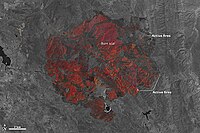
Growth and containment
Fire containment status Gray: contained; Red: active;%: percent contained
This page is based on this Wikipedia article Text is available under the CC BY-SA 4.0 license; additional terms may apply. Images, videos and audio are available under their respective licenses.