
San Luis Obispo County, officially the County of San Luis Obispo, is a county on the Central Coast of California. As of the 2020 census, the population was 282,424. The county seat is San Luis Obispo.
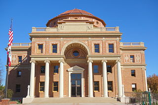
Atascadero is a city in San Luis Obispo County, California, United States, located on U.S. Route 101. Atascadero is part of the San Luis Obispo-Paso Robles metropolitan statistical area, which encompasses the extents of the county. Atascadero is farther inland than most other cities in the county, and as a result, usually experiences warmer, drier summers, and cooler winters than other nearby cities such as San Luis Obispo and Pismo Beach. The main freeway through town is U.S. 101. The nearby State Routes 41 and 46 provide access to the Pacific Coast and the Central Valley of California.

San Luis Obispo is a city and county seat of San Luis Obispo County, in the U.S. state of California. Located on the Central Coast of California, San Luis Obispo is roughly halfway between the San Francisco Bay Area in the north and Greater Los Angeles in the south. The population was 47,063 at the 2020 census.

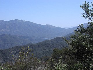
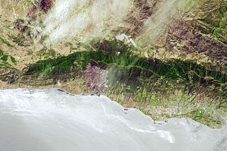
The Santa Lucia Mountains or Santa Lucia Range is a rugged mountain range in coastal central California, running from Carmel southeast for 140 miles (230 km) to the Cuyama River in San Luis Obispo County. The range is never more than 11 miles (18 km) from the coast. The range forms the steepest coastal slope in the contiguous United States. Cone Peak at 5,158 feet (1,572 m) tall and three miles (5 km) from the coast, is the highest peak in proximity to the ocean in the lower 48 United States. The range was a barrier to exploring the coast of central California for early Spanish explorers.
Los Padres National Forest is a United States national forest in southern and central California. Administered by the United States Forest Service, Los Padres includes most of the mountainous land along the California coast from Ventura to Monterey, extending inland. Elevations range from sea level to 8,847 feet (2,697 m).
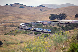
The Coast Line is a railroad line between Burbank, California and the San Francisco Bay Area, roughly along the Pacific Coast. It is the shortest rail route between Los Angeles and the Bay Area. Though not as busy as the Surf Line, the continuation of the Coast Line southbound to San Diego, it still sees freight movements and lots of passenger trains. The Pacific Surfliner, which runs from the San Diego Santa Fe Depot to San Luis Obispo via Union Station in Los Angeles, is the third busiest Amtrak route, and the busiest outside of the Northeast Corridor between Washington D.C. and Boston.

Santa Margarita is a unincorporated community located in San Luis Obispo County, California. It was founded in 1889 near Cuesta Peak and San Luis Obispo along State Route 58. The town's name comes from the Mexican Alta California land grant of Rancho Santa Margarita. It is home to the Santa Margarita de Cortona Asistencia site. For statistical purposes, the United States Census Bureau has defined Santa Margarita as a census-designated place (CDP). The population was 1,259 at the 2010 census.
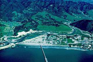
San Luis Obispo Creek is a stream, about 18 miles (29 km) long, in San Luis Obispo County, California. It drains a large coastal watershed that includes the city of San Luis Obispo, emptying into the Pacific Ocean at Avila Beach.
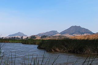
Chumash Peak is a 1,257 ft (383 m) mountain in San Luis Obispo County, California. It is just northwest of San Luis Obispo, on the south side of California State Route 1.
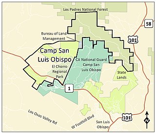
Camp San Luis Obispo is the original home of the California Army National Guard. It served as an Infantry Division Camp and Cantonment Area for the United States Army during World War II.
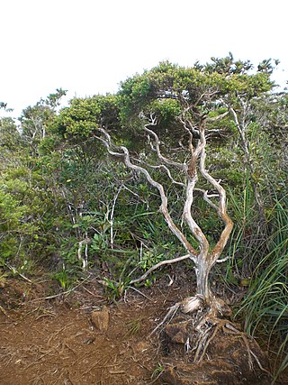
Dwarf forest, elfin forest, or pygmy forest is an uncommon ecosystem featuring miniature trees, inhabited by small species of fauna such as rodents and lizards. They are usually located at high elevations, under conditions of sufficient air humidity but poor soil. There are two main dwarf forest ecosystem types, involving different species and environmental characteristics: coastal temperate and montane tropical regions. Temperate coastal dwarf forest is common for parts of Southern California. Montane tropical forests are found across tropical highlands of Central America, northern South America and Southeast Asia. There are also other isolated examples of dwarf forests scattered across the world, while the largest dwarf forest is found in the Philippines.

Nacimiento-Fergusson Road is the only road across the Santa Lucia Range on the Central Coast of California, connecting California State Route 1 and the Big Sur coast to U.S. Route 101 and the Salinas Valley. The road is well-paved and maintained over its length, but is winding and has precipitous drops. It is widely regarded as one of the best motorcycling roads in central California due to its ocean views and forest setting.

The Zaca Fire was a wildfire in the San Rafael Mountains, northeast of the Santa Ynez Valley in Santa Barbara County, California. It was the single largest wildfire of the 2007 California wildfire season. The fire started on July 4, 2007, and by August 31, it had burned over 240,207 acres (972.083 km2), making it California's second largest fire in recorded history at that time after the Cedar Fire of 2003. As of 2023, it is California's 12th-largest recorded fire in modern history. The fire was contained on September 4, 2007, with the fire being brought under control on October 29, 2007.

Arctostaphylos luciana is a species of manzanita known by the common name Santa Lucia manzanita, is endemic to California.

Arctostaphylos obispoensis is a species of manzanita, known by the common names bishop manzanita and serpentine manzanita, endemic to California.

Paso Robles, officially El Paso de Robles, is a city in San Luis Obispo County, California, United States. Located on the Salinas River about 30 mi (48 km) north of San Luis Obispo, the city is known for its hot springs, abundance of wineries, production of olive oil, almond orchards, and playing host to the California Mid-State Fair. At the 2020 census, the population was 31,490.
The Sherpa Fire was a wildfire that burned in the Santa Ynez Mountains along the Gaviota Coast in the southwestern part of Santa Barbara County, California in June 2016. In a matter of hours the fire spread to over 1,400 acres (570 ha) as the fire was propelled by downslope sundowner winds. This offshore northerly wind contrasts with the more typical onshore flow and sent the fire down the canyons towards the ocean with gusts of over 35 miles per hour (56 km/h). The wildfire resulted in evacuations at two state beach campgrounds and some residences together with intermittent interruption of traffic on a state transportation route.
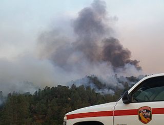
The Chimney Fire was a wildfire in the Santa Lucia Range, within San Luis Obispo County, California. The fire temporarily closed Hearst Castle to tourists and also forced the closure of Highway 1 along the scenic Big Sur coast for a time. By the time the fire was contained on September 6, 2016, it had burned 46,344 acres (188 km2) acres of land.

The Salinas Dam is a dam built on the Salinas River in San Luis Obispo County, California. Designed by Raymond A. Hill, the gravity dam features an arched design with an open spillway. The War Department began construction on the dam in mid-1941, as World War II began to reach the Pacific. The original intent of the dam was to supply water to Camp San Luis Obispo, which the Army was considering expanding to meet military needs. However, the camp’s wells ultimately provided sufficient water to the camp, and the reservoir water was never required or used by the military. Today, the dam operations are leased by the city of San Luis Obispo, to supply water to the city and surrounding agricultural areas. The reservoir created by the dam is known as the Santa Margarita Lake, or Santa Margarita Reservoir.

Cuesta Pass or La Cuesta Pass, colloquially referred to as simply the grade, is a low mountain pass in San Luis Obispo County on California's Central Coast. It crosses the southern Santa Lucia Range at an altitude of 1,522 feet (464 m), and connects San Luis Obispo, roughly 5 miles (8.0 km) to the south, with Atascadero, Paso Robles, and the Salinas Valley to the north. It is traversed by U.S. Route 101 and the Coast Line of the Union Pacific Railroad, and is better known for the long slope up to the pass from San Luis Obispo, in the canyon of San Luis Obispo Creek, which is redundantly named the "Cuesta Grade".

