Harlow Fire

Last updated

Harlow Fire
1961 Harlow Fire.png
The footprint of the Harlow Fire
Date(s)
  • July 10, 1961 (1961-07-10)
  • July 15, 1961 (1961-07-15)
  • (6 days)
Location Mariposa and Madera counties, California, United States
Coordinates 37°21′58″N119°43′34″W / 37.366°N 119.726°W / 37.366; -119.726
Statistics
Burned area43,329 acres (17,535 ha; 68 sq mi; 175 km2)
Impacts
Deaths2
Non-fatal injuries22
Structures destroyed106 (20 damaged)
Damage
  • $2 million
  • (equivalent to about $15.6 million in 2023)
Ignition
CauseArson
Map
USA California location map.svg
FireIcon.svg
The general location of the Harlow Fire in Central California

The Harlow Fire was a large wildfire in Central California's Mariposa and Madera counties in mid-July, 1961. The fire ignited on July 10 and burned rapidly, covering 43,329 acres (17,535 hectares) before it was fully surrounded by containment lines on July 13 and fully controlled on July 15. During those six days the Harlow Fire destroyed 106 buildings, devastating the rural communities of Ahwahnee and Nipinnawasee in the foothills of the Sierra Nevada to the west of Yosemite National Park and the Sierra National Forest. Two residents of Ahwahnee were killed while fleeing the fire in their car.

Contents

Background

Between 1959 and 1962, California experienced a multi-year and large-scale drought. [1] :4 At the time, it was one of the worst in the state's recorded history, and the resulting wildfire risk was anticipated. Fire officials readied 6,000 personnel, 60 air tankers, and dozens of helicopters in advance of the fire season. [2]

Progression

The Harlow Fire began in the morning on July 10, 1961, on Usona Road beneath Stumphill Mountain in Mariposa County. [3] [4] [5] The fire was first reported by either the Green Mountain fire lookout, who called Cal Fire to relay a smoke sighting, [6] or by the Miami Mountain fire lookout with the U.S. Forest Service. [7] The responding Cal Fire personnel discovered a 2.5-acre (1.0 ha) fire near Indian Peak. [6]

By 11:00 a.m. on July 11, the fire had crossed the East Fork Chowchilla River, outflanking firefighters on Miami Mountain and burning along Metcalf Gap Road and having burned about 8,200 acres (3,300 ha) in total. [7] In the afternoon on July 11, the fire began to move with unprecedented rapidity. Winds near the surface were calm, but 1,500 feet (460 m) up they were blowing vigorously out of the northwest and towards the southeast. At some point the Harlow Fire entered an area of thick, dry vegetation near Metcalf Gap and intensified, generating a large convective smoke column. When the column met the prevailing winds it scattered embers and firebrands to the southeast, starting spot fires ahead of the main fire front that themselves grew and intensified. A U.S. Forest Service meteorologist described the result as "a full-scale, moving firestorm". [5]

Three distinct fire fronts pushed southeast: one burned directly through Nipinnawasee before diminishing as it entered open oak woodlands less conducive to fire growth; another burned through Ahwahnee before doing the same. The third pushed through the drainages of Cook Creek and the upper Fresno River before turning south up Deadwood Peak. [5] Evacuation plans for Ahwahnee and Nipinnawasee were still being developed by county authorities when the blow-up occurred, destroying all telephone communications lines in the area. Residents and others in the area were dependent on the mobile radios in emergency responders' vehicles to spread the word. [8] The overall firestorm's activity slackened by 6:00 p.m. The fire burned approximately 18,000–23,000 acres (7,300–9,300 ha) in two hours. [5] [8] This roughly 31-square-mile (80 km2) expansion marked the fastest fire growth ever recorded in California. [9]

By Wednesday, July 12, seven aircraft had been assigned to help fight the Harlow Fire, flying 30 sorties to drop borate-based fire retardant on and in front of the flaming front on that day alone. They included two B-17 Flying Fortress bombers, two PBY Catalina flying boats, two TBM Avenger torpedo bombers, and an "AJ3 Tiger" bomber. [10] The aircraft remained on the fire until its containment. That same day, officials ordered the evacuation of campgrounds at Bass Lake. [11] At 12:30 p.m., authorities closed California State Route 41 northbound of Coarsegold to traffic. [12] Now 10 miles (16 km) south of Yosemite, the Harlow Fire had by this point burned approximately 37,000 acres (15,000 ha) and was only 30 percent contained. [3]

The Harlow Fire was declared fully contained on Thursday, July 13. [11] That same day, California governor Pat Brown declared a state of disaster for Madera County on account of the fire and at the request of several members of the state legislature. [13] By this time the forces brought to bear on the fire included—in addition to the seven aircraft—67 fire engines and 16 bulldozers, operated by and in concert with 1,820 personnel from several different agencies, including the California Department of Forestry and Fire Protection (Cal Fire) and the Forest Service. [11] The number of personnel peaked on July 14 at 2,181. [4]

Late on the 14th the Harlow Fire escaped its containment lines again in two places, starting spot fires on Thornberry Mountain between Oakhurst and Coarsegold and on Deadwood Mountain. Aircraft, bulldozers, and ground crews all joined forces and managed to subdue the spot fires by 6:00 p.m. [14] The fire was declared fully controlled at 10:00 p.m. on July 15. [15] The fire burned 43,329 acres (17,535 ha) in total. [16] [17] :38 Most of the burned area lay on land under Cal Fire's firefighting responsibility, adjacent to the Sierra National Forest, [5] though 1,200 acres (490 ha) of the National Forest did burn. [18]

Effects

Two people died in the Harlow Fire. [19] George Kipp and Edna Kipp, residents of Ahwahnee, were killed in their vehicle on Road 628, or Roundhouse Road, two miles north of Ahwahnee when their car became stuck on the unpaved road. [20] George Kipp was found deceased at the scene inside the vehicle; Edna Kipp died later that day at the Madera County Hospital. [3] [21] Their causes of death were listed as burns and asphyxiation respectively. [20] Twenty-two other people were injured in the fire. [22] At least one firefighter was injured after cutting their foot with an axe. [4]

The fire destroyed 106 structures and consequently numbered among California's twenty most destructive recorded wildfires for at least forty years before being surpassed by many others. [19] [23] At least 78 of the burned structures were homes or outbuildings, though stores, taverns, three sawmills, and other various establishments burned. [14] Another 20 dwellings were damaged. Only 35 of the damaged or destroyed homes had insurance. [22] In Nipinnawasee, along with many homes the fire also destroyed the town's post office, grocery store, gas station, and the Nipinnawasee Hotel. In Ahwahnee the toll included the post office, gas station, the Sierra Grocery, and the Ahwahnee Inn. [21] Fifty of Ahwahnee's 60 buildings were destroyed, [3] as were 10 of Nipinnawasee's 12. [12] Losses amounted to $2 million, roughly equivalent to $15.6 million in 2023. [24] [25] Ahwahnee, benefiting from the help of Red Cross donations and Small Business Administration loans, rebuilt and largely recovered in the following years. Nipinnawasee "never revived", according to a Madera Tribune report written six years after the fire. [26]

Hundreds of people, largely children at various summer camps, were forced to evacuate from the Bass Lake area. [27] The Fresno Bee reported minor incidents of looting in evacuated areas in Oakhurst. [4] The Red Cross chapter in Madera County helped organize emergency relief efforts for those displaced by the fire, distributing supplies (such as tubs, soap, water, and food) and information alike from a post set up in the Aragon Hotel in the city of Madera. [21] The American Red Cross later provided a further $71,000 in grants to fire victims. [28]

The fire destroyed several thousand acres of commercial timber stands, [13] including a large reforestation project begun in the wake of the Nelson Cove Fire in 1959. [3] More than 5,000 acres (2,000 ha) of the burn area were re-seeded in early November by aircraft that dropped more than 22 tons of rye grass seed. The effort was organized by the Madera County Farm Advisors and several local figures. [29]

Many residents who had lost property in the Harlow Fire expressed discontent with the way Cal Fire had fought it, leveling charges that firefighters had either let structures burn while they idled, or not adequately protected them through the use of back-burning or firebreaks. [30] [31] Cecil E. Metcalf, a deputy state forester with Cal Fire who had led the fire suppression effort, denied the claims and argued that the prioritization of life (including that of the firefighters) over property, as well as the speed of the fire, were responsible for the manner in which firefighting had been conducted. [31] The California State Assembly held a hearing on the fire and the firefighting effort in Fresno on October 30, 1961, attended by more than 200 fire area residents and featuring testimony by more than 20 of them. [25] [32] [33]

Later fires in the footprint of the Harlow Fire included the River Fire in 2021 and the Oak Fire in 2022. [34] [35]

Cause

An investigator with the Madera County District Attorney's office and an officer with Cal Fire spent several days in the Harlow Fire area questioning residents. They eventually narrowed down their inquiries to Fredrick E. Litke, an 18-year-old who had been one of the first people at the scene of the fire and who had assisted in the firefight, suffering a burned ear. [36] The investigators took Litke in for questioning in Madera on July 25. After a failed polygraph test and eight hours of questioning, Litke allegedly "broke down and told his story" the following day. Litke had been employed at the nearby Harlow Ranch and, according to his confession, had set the fire alight on July 10—his 18th birthday—using matches after hearing another employee muse that it would be easier to round up the ranch's horses if some brush were burned. Litke claimed he had counted on the fire burning out once it reached a horse trail on the ridgetop above the ignition point. [36]

The following day, Litke was charged with one count of arson and two counts of murder. When the case went before the Madera County grand jury on August 23, they dropped the murder charges and reduced the count of arson to one count of "starting a forest fire". The matter then entered Madera County Superior Court, going to trial on December 18. There were two days of testimony, during which Litke's defense counsel maintained that his confession had been made under duress. [37] [38] After two hours of deliberation, the twelve-member Superior Court jury unanimously found Litke innocent on December 20, 1961. The jury indicated that their decision was made partly because they felt malice did not figure into Litke's alleged decision to set the fire, having heard a doctor testify that Litke was emotionally immature and insecure. [39]

Cal Fire officially records the cause of the Harlow Fire as arson. [19]

See also

Related Research Articles

<span class="mw-page-title-main">Madera County, California</span> County in California, United States

Madera County, officially the County of Madera, is located at the geographic center of the U.S. state of California. It features a varied landscape, encompassing the eastern San Joaquin Valley and the central Sierra Nevada, with Madera serving as the county seat. Established in 1893 from part of Fresno County, Madera County reported a population of 156,255 in the 2020 census.

<span class="mw-page-title-main">Oakhurst, California</span> Census-designated place in California, United States

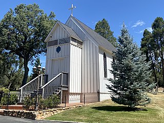
Oakhurst is a census-designated place (CDP) in Madera County, California, United States, 14 miles (23 km) south of the entrance to Yosemite National Park, in the foothills of the Sierra Nevada. At an elevation of 2,274 ft (693 m), Oakhurst is situated at the junction of Highway 41 and Highway 49, marking the southern end of California's Gold Country. It is part of the Madera metropolitan statistical area.

<span class="mw-page-title-main">Nelder Grove</span> Giant sequoia grove in Madera County, California, United States

Nelder Grove, located in the western Sierra Nevada within the Sierra National Forest in Madera County, California, is a Giant sequoia grove that was formerly known as Fresno Grove. The grove is a 1,540-acre (6.2 km2) tract containing 54 mature Giant Sequoia trees, the largest concentration of giant sequoias in the Sierra National Forest. The grove also contains several historical points of interest, including pioneer cabins and giant sequoia stumps left by 19th century loggers.

The Laguna Fire, also known as the Kitchen Creek Fire or the Boulder Oaks Fire, was a 175,425-acre (70,992 ha) wildfire that burned from September 22 to October 4, 1970, in the Laguna Mountains and East County region of San Diego County in Southern California. It was one of many wildfires in a massive conflagration that spanned across the state from September 22 to October 4, 1970. At the time, it was the second-largest fire in the recorded history of California after the 1932 Matilija Fire.

<span class="mw-page-title-main">Ahwahnee, California</span> Census-designated place in California, United States

Ahwahnee is a census-designated place in Madera County, California, United States. It is located 5.25 miles (8.4 km) west of Yosemite Forks, at an elevation of 2,326 feet (709 m). The population was 2,296 at the 2020 census.

<span class="mw-page-title-main">Angora Fire</span> 2007 wildfire in Northern California

The Angora Fire was a 2007 wind-driven wildfire in El Dorado County, California. It started near North Upper Truckee Road subdivision near Angora Lakes, Fallen Leaf Lake, Echo Lake and South Lake Tahoe, California around 2:15 PM on Sunday, June 24, 2007, as a result of an illegal campfire. As of July 2, 2007, the fire was 100% contained, and 100% control was achieved on July 10. The fire burned 3,100 acres (12.5 km2), destroyed 242 residences and 67 commercial structures, and damaged 35 other homes. At the peak of the fire, there were as many as 2,180 firefighters involved in battling the blaze. The fire cost $13.5 million to fight and caused at least $150 million in property damage.

<span class="mw-page-title-main">2008 California wildfires</span> Wildfire season

The 2008 California wildfire season was one of the most devastating in the state of the 21st century. While 6,255 fires occurred, about two-thirds as many as in 2007, the total area burned— 1,593,690 acres —far exceeded that of previous years.

Nipinnawasee is a census-designated place in Madera County, California, United States. It is located 1 mile (1.6 km) southeast of Miami Mountain in the Sierra Nevada, 14 miles (22.5 km) southeast of Mariposa, at an elevation of 2,930 feet (890 m). The population was 434 at the 2020 census.

<span class="mw-page-title-main">2015 California wildfires</span> Wildfire season

The 2015 California wildfire season was a series of wildfires that burned across the state of California. By the end of 2015 a total of 8,745 fires were recorded, burning 893,362 acres (3,615 km2) across the state. Approximately 3,159 structures were damaged or destroyed by wildfires, and at least 7 fatalities were recorded.

<span class="mw-page-title-main">Rough Fire</span> 2015 wildfire in Central California

The Rough Fire was a major wildfire in Fresno County, California, and the largest of the 2015 California wildfire season. The fire was ignited by a lightning strike on July 31 and burned 151,623 acres (61,360 ha), largely in the Sierra National Forest and the Sequoia National Forest, before it was declared contained on November 6, 2015. At the time it occurred, the fire was the thirteenth largest in recorded California history.

<span class="mw-page-title-main">2018 California wildfires</span> Overview of major wildfires

The 2018 wildfire season was the deadliest and most destructive wildfire season in California history. It was also the largest on record at the time, now third after the 2020 and 2021 California wildfire seasons. In 2018, there were a total of 103 confirmed fatalities, 24,226 structures damaged or destroyed, and 8,527 fires burning 1,975,086 acres (799,289 ha), about 2% of the state's 100 million acres of land. Through the end of August 2018, Cal Fire alone spent $432 million on operations. The catastrophic Camp Fire alone killed at least 85 people, destroyed 18,804 buildings and caused $16.5 billion in property damage, while overall the fires resulted in at least $26.347 billion in property damage and firefighting costs, including $25.4 billion in property damage and $947 million in fire suppression costs.

<span class="mw-page-title-main">2020 California wildfires</span> An overview of major wildfires in California during the year 2020

The 2020 California wildfire season, part of the 2020 Western United States wildfire season, was a record-setting year of wildfires in California. By the end of the year, 9,917 fires had burned 4,397,809 acres (1,779,730 ha), more than 4% of the state's roughly 100 million acres of land, making 2020 the largest wildfire season recorded in California's modern history, though roughly equivalent to the pre-1800 levels which averaged around 4.4 million acres yearly and up to 12 million in peak years. California's August Complex fire has been described as the first "gigafire", burning over 1 million acres across seven counties, an area larger than the state of Rhode Island. The fires destroyed over 10,000 structures and cost over $12.079 billion in damages, including over $10 billion in property damage and $2.079 billion in fire suppression costs. The intensity of the fire season has been attributed to a combination of more than a century of poor forest management and higher temperatures resulting from climate change.

<span class="mw-page-title-main">Creek Fire (2020)</span> 2020 wildfire in Central California

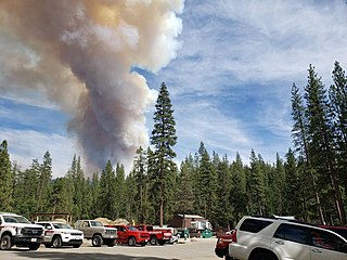
The 2020 Creek Fire was a very large wildfire in central California's Sierra National Forest, in Fresno and Madera counties. One of the most significant fires of California's record-setting 2020 wildfire season, it began on September 4, 2020, and burned 379,895 acres (153,738 ha) over several months until it was declared 100% contained on December 24, 2020. The Creek Fire is the fifth-largest wildfire in recorded California history and the second-largest single fire—i.e. not part of a larger wildfire complex—following the 2021 Dixie Fire.

<span class="mw-page-title-main">SQF Complex</span> 2020 wildfire in Central California

The SQF Complex fire—also called the SQF Lightning Complex—was a wildfire complex that burned in Tulare County in Central California in 2020. Comprising the Castle and Shotgun fires, it affected Sequoia National Forest and adjacent areas. Both fires began on August 19, 2020, and burned a combined total of 175,019 acres before the complex as a whole was declared 100 percent contained on January 6, 2021. In the course of the fires, 232 structures were destroyed. There were no fatalities.

<span class="mw-page-title-main">River Fire (2021)</span> 2021 wildfire in Northern California

The River Fire was a destructive 2021 wildfire that burned 2,619 acres (1,060 ha) near Colfax in Nevada County and Placer County, California. The fire broke out on August 4, 2021, and burned 2,619 acres (1,060 ha) before it was fully contained on August 13, 2021. The River Fire destroyed 142 structures, damaged 21 more, and resulted in four injuries to firefighters and civilians. It was the fifth most destructive fire of California's 2021 wildfire season. The exact cause of the fire is unknown, but it was determined to have been of human origin by investigators who traced the ignition to a campground by the Bear River west of Colfax.

<span class="mw-page-title-main">Oak Fire (2022)</span> 2022 wildfire in Central California

The Oak Fire was a destructive wildfire that burned north of the community of Bootjack in Mariposa County, California and in the Sierra National Forest, during the 2022 California wildfire season. The fire was reported on July 22, 2022, and burned 19,244 acres (7,788 ha) before being fully contained on September 2, 2022. On June 16, 2023, a 71-year-old man was arrested on suspicion of arson for starting the fire.

<span class="mw-page-title-main">49er Fire</span> 1988 wildfire in Northern California

The 49er Fire was a destructive wildfire in 1988 in California's Nevada County and Yuba County. The fire was ignited on September 11 when a man accidentally set brush on fire by burning toilet paper near Highway 49. Driven by severe drought conditions and strong, dry winds, firefighting crews were hard-pressed to stop the fire's advance until winds calmed and humidity levels recovered. The fire burned 33,700 acres throughout the foothills of the Sierra Nevada, impinging on the communities of Lake Wildwood, Rough and Ready, and Smartsville before officials declared it fully contained on September 16.

<span class="mw-page-title-main">2001 California wildfires</span> An overview of major wildfires in California during the year 2001

The 2001 California wildfire season was a series of wildfires that burned throughout the U.S. state of California during 2001. According to California Department of Forestry and Fire Protection statistics, 9,317 fires burned a total of 377,340 acres.

<span class="mw-page-title-main">2000 California wildfires</span> An overview of major wildfires in California during the year 2000

The 2000 California wildfire season was a series of wildfires that burned throughout the U.S. state of California during 2000. According to California Department of Forestry and Fire Protection statistics, 7,622 fires burned a total of 295,026 acres. Cal Fire wildfire suppression costs for fires that burned within the agency's jurisdiction amounted to $109 million. Damages for the same amounted to $87.3 million, with a total of 389 structures lost. The largest wildfires of the year in California were the Manter and Storrie fires, which burned 74,000 and 55,000 acres in Tulare and Plumas counties respectively.

References

  1. Drought in California (PDF) (Report). California Department of Water Resources. Fall 2012. Archived (PDF) from the original on October 6, 2022. Retrieved April 18, 2024.
  2. Boyarsky, Bill (July 6, 1961). "Protracted Drought Is Carrying Fire Threats". Santa Cruz Sentinel . Associated Press. p. 3. Archived from the original on April 18, 2024. Retrieved April 18, 2024 via Newspapers.com.
  3. 1 2 3 4 5 "Sierra Fire Kills 2, Burns Ahwahnee, Nipinnawasee". The Fresno Bee . July 12, 1961. pp.  1-A, 6-A. Archived from the original on March 29, 2024. Retrieved March 29, 2024 via Newspapers.com.
  4. 1 2 3 4 Kidder, Karl M. (July 14, 1961). "New Sierra Blaze Rages; Harlow Fire Is Contained". The Fresno Bee . pp.  1-A, 4-A. Archived from the original on March 29, 2024. Retrieved March 29, 2024 via Newspapers.com.
  5. 1 2 3 4 5 Kidder, Karl M. (July 23, 1961). "Metcalf: Never Saw Anything Like Harlow Fire In 35 Years". The Fresno Bee . p. 20-C. Archived from the original on March 29, 2024. Retrieved March 29, 2024 via Newspapers.com.
  6. 1 2 "Remembering the Harlow Fire". The Madera Tribune . September 16, 2020. Archived from the original on March 29, 2024. Retrieved April 1, 2024.
  7. 1 2 "Runaway Brush, Timber Fire Perils Nipinnawasee". Madera Tribune . July 11, 1961. Archived from the original on April 1, 2024. Retrieved April 1, 2024 via California Digital Newspaper Collection.
  8. 1 2 "Mobile Radios Cut Fire Peril". Los Angeles Times . Associated Press. July 20, 1961. p. 28. Archived from the original on March 29, 2024. Retrieved March 29, 2024 via Newspapers.com.
  9. Melley, Brian (August 20, 2021). "Explosive California wildfires could burn into December". Associated Press . Archived from the original on March 29, 2024. Retrieved April 5, 2024.
  10. "Flying Fortresses Find New Foe in Fire". The Fresno Bee . July 13, 1961. p. 5-A. Archived from the original on March 29, 2024. Retrieved March 29, 2024 via Newspapers.com.
  11. 1 2 3 Kidder, Karl M. (July 13, 1961). "Sierra Blaze is Contained After 40,000 Acre Sweep". The Fresno Bee . pp.  1-A, 5-A. Archived from the original on March 29, 2024. Retrieved March 29, 2024 via Newspapers.com.
  12. 1 2 "Fire Destroys Ahwahnee, Nipinnawassee; Threatens Oakhurst, Bass Lake, North Fork". Madera Tribune . July 12, 1961. Archived from the original on April 1, 2024. Retrieved April 1, 2024 via California Digital Newspaper Collection.
  13. 1 2 "County Declared Disaster Area; Firemen Halting Fire's Advance". Madera Tribune . July 13, 1961. p. 1. Archived from the original on April 15, 2024. Retrieved April 15, 2024 via California Digital Newspaper Collection.
  14. 1 2 "Flames Again Jump Harlow Fire Lines". The Fresno Bee . McClatchy News Service. July 15, 1961. p. 1-A. Archived from the original on March 29, 2024. Retrieved March 29, 2024 via Newspapers.com.
  15. Kidder, Karl M. (July 16, 1961). "Harlow Fire Controlled". The Fresno Bee . pp. 4-A. Archived from the original on March 29, 2024. Retrieved March 29, 2024 via Newspapers.com.
  16. "The 1961 Harlow Fire, Mariposa County". Firewise Madera County. Archived from the original on March 29, 2024. Retrieved April 18, 2024.
  17. Cal Fire Madera-Mariposa-Merced Unit: 2023 Unit Strategic Fire Plan (PDF) (Report). California Department of Forestry and Fire Protection (Cal Fire). May 5, 2023. Archived (PDF) from the original on March 29, 2024. Retrieved April 18, 2024.
  18. "Crews Mop Up Snags Left In Wake Of Haslett Fire". The Fresno Bee . October 18, 1961. p. 1-A. Archived from the original on March 29, 2024. Retrieved March 29, 2024 via Newspapers.com.
  19. 1 2 3 "20 Largest California Wildland Fires (By Structures Lost)". www.fire.ca.gov. California Department of Forestry and Fire Protection (Cal Fire). 2001. Archived from the original on October 31, 2001.
  20. 1 2 "Services Set For Fire Victims". Madera Tribune . July 13, 1961. Archived from the original on April 2, 2024. Retrieved April 2, 2024 via California Digital Newspaper Collection.
  21. 1 2 3 Evon, Lou (July 13, 1961). "First Emergency Supplies Go To Fire Ravaged Area". The Fresno Bee . p. 4-A. Archived from the original on March 29, 2024. Retrieved March 29, 2024 via Newspapers.com.
  22. 1 2 Rehart, Schyler (October 19, 1961). "Community Of Ahwahnee Regains Feet; Ruins Gone". Madera Tribune . pp. 1–2. Archived from the original on April 15, 2024. Retrieved April 15, 2024 via California Digital Newspaper Collection.
  23. "Top 20 Most Destructive California Wildfires" (PDF). www.fire.ca.gov. California Department of Forestry and Fire Protection (Cal Fire). March 27, 2024. Archived (PDF) from the original on April 15, 2024. Retrieved April 17, 2024.
  24. "Committee Will Aid In Fire Rebuilding". The Fresno Bee . July 15, 1961. pp. 3-B. Archived from the original on March 29, 2024. Retrieved March 29, 2024 via Newspapers.com.
  25. 1 2 "Harlow Fire Hearing Opens Today". Madera Tribune . October 30, 1961. p. 1. Archived from the original on April 18, 2024. Retrieved April 18, 2024.
  26. Anthony, H.M. (July 14, 1967). "Mountain Residents Remember Holocaust Of 1961 Harlow Fire". Madera Tribune . p. 3. Archived from the original on April 5, 2024. Retrieved April 15, 2024 via California Digital Newspaper Collection.
  27. "Youngsters Evacuated To Fresno Return Home". The Fresno Bee . July 13, 1961. pp. 4-A. Archived from the original on March 29, 2024. Retrieved March 29, 2024.
  28. "Red Cross, State Aid Fire Victims". Sanger Herald . September 7, 1961. p. 2A. Archived from the original on March 29, 2024. Retrieved March 29, 2024 via Newspapers.com.
  29. "All Around Ahwahnee". Madera Tribune . November 7, 1961. Archived from the original on April 2, 2024. Retrieved April 2, 2024 via California Digital Newspaper Collection.
  30. "Blaze Victims Help Each Other, Criticise State's Firefighting". The Fresno Bee . July 14, 1961. p. 3C. Archived from the original on April 17, 2024. Retrieved April 17, 2024 via Newspapers.com.
  31. 1 2 "Metcalf Denies Fire Mismanagement". Madera Tribune . July 17, 1961. p. 1. Archived from the original on April 2, 2024. Retrieved April 17, 2024 via California Digital Newspaper Collection.
  32. "Lack of Co-Ordination Cited In Battling Harlow Forest Fire". Hanford Sentinel . McClatchy News Service. October 31, 1961. p. 2. Archived from the original on March 29, 2024. Retrieved March 29, 2024 via Newspapers.com.
  33. "Harlow Fire Victims Tell Assembly Interim Committee Of Apathy, Poor Coordination". Madera Tribune . October 31, 1961. pp. 1–2. Archived from the original on April 18, 2024. Retrieved April 18, 2024.
  34. Sheehan, Tim (July 12, 2021). "60 years before the River Fire, another major wildfire devastated the same foothill area". The Fresno Bee . Archived from the original on April 2, 2024. Retrieved April 2, 2024.
  35. Little, Greg (September 15, 2022). "Oak Fire cause still undetermined". Mariposa Gazette. Archived from the original on March 29, 2024. Retrieved April 5, 2024.
  36. 1 2 "Youth Admits Setting Fatal Harlow Blaze". The Fresno Bee . McClatchy News Service. July 26, 1961. pp.  1-A, 6-A. Archived from the original on March 29, 2024. Retrieved March 29, 2024 via Newspapers.com.
  37. "Did emotions sway the Harlow fire jury?". Madera Tribune . September 23, 2020. Archived from the original on March 30, 2024. Retrieved April 18, 2024.
  38. "No guilt in the Harlow fire?". Madera Tribune . September 19, 2020. Archived from the original on March 29, 2024. Retrieved April 18, 2024.
  39. Rehart, Schyler (December 21, 1961). "Jury Acquits Frederick Litke". Madera Tribune . pp. 1–2. Archived from the original on April 18, 2024. Retrieved April 18, 2024 via California Digital Newspaper Collection.