The Santa Monica Mountains are a coastal mountain range in Southern California, next to the Pacific Ocean. It is part of the Transverse Ranges. The Santa Monica Mountains National Recreation Area encompasses this mountain range. Because of its proximity to densely populated regions, it is one of the most visited natural areas in California.
Los Padres National Forest is a United States national forest in southern and central California. Administered by the United States Forest Service, Los Padres includes most of the mountainous land along the California coast from Ventura to Monterey, extending inland. Elevations range from sea level to 8,847 feet (2,697 m).

Leo Carrillo State Park is a state park in Los Angeles County, California, United States. Situated along the Malibu coast, the park is a component of Santa Monica Mountains National Recreation Area. With 1.5 miles (2.4 km) of beach, the parkland stretches into the Santa Monica Mountains. The park has expanded into Ventura County and also includes management of County Line Beach. California State Route 1 runs through the park, where it intersects with the western terminus of the Mulholland Highway. The 2,513-acre (1,017 ha) park was established in 1953. It is named for actor and conservationist Leo Carrillo (1880–1961), who served on the State Parks commission.

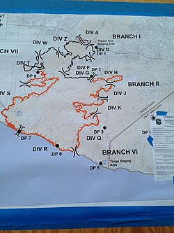
The Topanga Fire was a wildfire that ignited on September 28, 2005, in the Santa Susana Mountains, to the northwest of Chatsworth and the San Fernando Valley in Southern California.

Lake Casitas is a reservoir in Ventura County, California, built by the United States Bureau of Reclamation and completed in 1959. The project provides drinking water and water for irrigation. A secondary benefit is flood control. It was the venue for canoeing and rowing at the 1984 Summer Olympics.
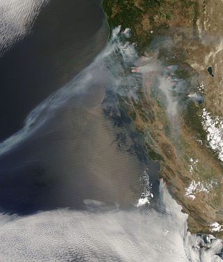
The 2008 California wildfire season was one of the most devastating in the state of the 21st century. While 6,255 fires occurred, about two-thirds as many as in 2007, the total area burned— 1,593,690 acres —far exceeded that of previous years.
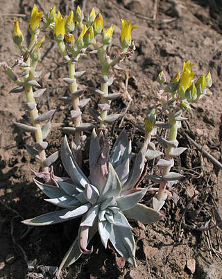
Dudleya verityi is a rare species of succulent plant known by the common name Verity's liveforever. It is endemic to Ventura County, California, where it is known from only three occurrences in the vicinity of Conejo Mountain between Camarillo and Thousand Oaks. It probably occurs in a few additional locations nearby which have not yet been officially vouchered.

The 2009 California wildfires were a series of 9,159 wildfires that were active in the US state of California, during the year 2009. The fires burned more than 422,147 acres of land from early February through late November, due to Red Flag conditions, destroying hundreds of structures, injuring 134 people, and killing four. The wildfires also caused at least US$134.48 million in damage. Although the fires burned many different regions of California in August, the month was especially notable for several very large fires which burned in Southern California, despite being outside of the normal fire season for that region.

The Conejo Grade is a 7% grade incline on a section of US 101. Also known as the Camarillo Grade, it links Thousand Oaks and cities of the Conejo Valley, with Camarillo and the cities on the Oxnard Plain. With a summit elevation of 841.1 feet (256.4 m), California Highway Patrol inspection stations for trucks are situated on both sides of the highway at the upper terminus of the grade.

Rancho Sierra Vista in Ventura County, California, United States, is one of the last intact ranches from the first half of the twentieth century in the Santa Monica Mountains. The majority of the landscape is much as it was 100 years ago. The area is now owned by the Santa Monica Mountains National Recreation Area, a unit of the National Park System.
The Simi Fire was a devastating 2003 wildfire that burned 108,204 acres (438 km2) of land in the Simi Hills and southeastern Simi Valley in eastern Ventura County and western Los Angeles County, in the U.S. state of California. The Simi Fire was one of multiple large, fast-moving, and destructive wildfires in Southern California in October 2003, in a fire siege that included the Cedar, Old, and Grand Prix fires. The Simi Fire resulted in no fatalities but did cause 21 injuries. The cause of the fire remains unknown.
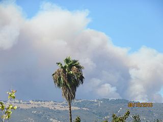
The Sherpa Fire was a wildfire that burned in the Santa Ynez Mountains along the Gaviota Coast in the southwestern part of Santa Barbara County, California in June 2016. In a matter of hours the fire spread to over 1,400 acres (570 ha) as the fire was propelled by downslope sundowner winds. This offshore northerly wind contrasts with the more typical onshore flow and sent the fire down the canyons towards the ocean with gusts of over 35 miles per hour (56 km/h). The wildfire resulted in evacuations at two state beach campgrounds and some residences together with intermittent interruption of traffic on a state transportation route.
The Rey Fire was a wildfire that burned in the area southeast of Lake Cachuma in the range above the Santa Ynez River, Santa Barbara County, California, in 2016. By the time the fire was contained, it had burned 32,606 acres (131.95 km2).

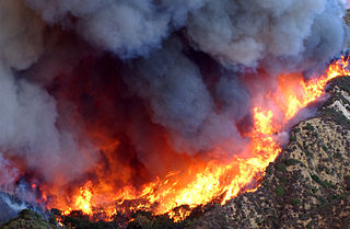
The Thomas Fire was a massive wildfire that affected Ventura and Santa Barbara Counties, and one of multiple wildfires that ignited in southern California in December 2017. It burned approximately 281,893 acres before being fully contained on January 12, 2018, making it the largest wildfire in modern California history at the time. It was surpassed by the Ranch Fire, part of the Mendocino Complex, in August 2018. The fire is currently the eighth-largest wildfire in modern California history, as of 2024. The fire was officially declared out on June 1, 2018, after more than two months in which no hotspots were detected. The Thomas Fire destroyed at least 1,063 structures, while damaging 280 others; and the fire caused over $2.2 billion in damages, including $230 million in suppression costs, becoming the seventh-most destructive wildfire in state history at the time. As of August 2020, the Thomas Fire is California's tenth-most destructive wildfire. Ventura's agriculture industry suffered at least $171 million in losses due to the Thomas Fire.
A series of 29 wildfires ignited across Southern California in December 2017. Six of the fires became significant wildfires, and led to widespread evacuations and property losses. The wildfires burned over 307,900 acres (1,246 km2), and caused traffic disruptions, school closures, hazardous air conditions, and power outages; over 230,000 people were forced to evacuate. The largest of the wildfires was the Thomas Fire, which grew to 281,893 acres (1,140.78 km2), and became the largest wildfire in modern California history, until it was surpassed by the Ranch Fire in the Mendocino Complex, in the following year.

A series of mudflows occurred in Southern California in early January 2018, particularly affecting areas northwest of Montecito in Santa Barbara County. The incident was responsible for 23 deaths, although the body of one of the victims has never been found. Approximately 163 people were hospitalized with various injuries, including four in critical condition. The disaster occurred one month after a series of major wildfires. The conflagrations devastated steep slopes, which caused loss of vegetation and destabilization of the soil and greatly facilitated subsequent mudflows. The mudflows caused at least $177 million in property damage, and cost at least $7 million in emergency responses and another $43 million to clean up.

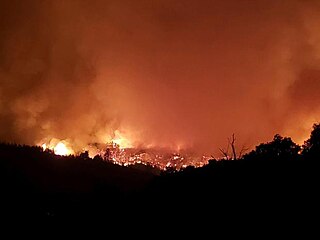
The Woolsey Fire was a wildfire that started in Los Angeles County and spread north to neighboring Ventura County, both located in the U.S. state of California. The fire ignited on November 8, 2018 and wasn't fully contained until November 21, 2018. The fire burned 96,949 acres of land, destroyed 1,643 structures, killed three people, and prompted the evacuation of more than 295,000 people. It was one of several fires in California that ignited on the same day, along with the nearby Hill Fire and the destructive Camp Fire in Northern California.
The Dolan Fire was a large wildfire that burned in the Big Sur region and other parts of the Santa Lucia mountain range in Monterey County, California, in the United States as part of the 2020 California wildfire season. The fire began at approximately 8:15 p.m. on August 18, 2020. On September 8, 15 firefighters were injured, one critically, when they were forced to deploy emergency fire shelters at Nacimiento Station. Ten adult California condors and two chicks died in the blaze, which began about a mile south of the Big Sur Condor Sanctuary in Monterey County. The nonprofit Ventana Wildlife Society of Monterey lost a sanctuary that has been used to release the captive-bred condors into the wild since 1997. While no people or condors were at the 80-acre (32 ha) site, a research building, pens, and other facilities were destroyed.
The Silverado Fire was a wildfire that burned in October and November 2020 in southern Orange County, California northeast of Irvine. The fire started on October 26 around 6:47 AM near Orange County Route S-18 and Silverado Canyon Road, fueled by strong Santa Ana winds gusting up to 80 miles per hour (130 km/h) and low humidity. Orange County Fire Authority Chief Brian Fennessy stated, "The winds were extraordinary even by Santa Ana standards. Fire spread is exceeding more than anything I've seen in my 44 years." The fire initially moved south from Loma Ridge toward the Orchard Hills, Northwood and Portola Springs communities of Irvine before moving southeast through Limestone Canyon and toward the communities of Foothill Ranch and Lake Forest. The fire burned in a path similar to that taken by the 2007 Santiago Fire, mostly through terrain that had not seen significant burning in the 13 years since that fire. 100% containment was announced on November 7, 2020.

The Kinneloa Fire was a destructive wildfire in October 1993 in Los Angeles County, California. The fire burned 196 structures in the San Gabriel Mountains foothill communities of Altadena, Kinneloa Mesa, and Sierra Madre, becoming the then-twelfth most destructive wildfire in recorded California history and one of the most destructive wildfires in Los Angeles County history. The fire resulted in a multitude of minor injuries and one fatality; an elderly man died of pneumonia complicated by smoke inhalation, though a father and son were also killed in a debris flow in the burn area more than four months later.