Cocos Fire

Last updated
Cocos Fire
Cocos fire - part of May 2014 San Diego County wildfires.jpg
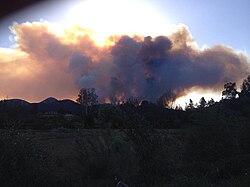
The Cocos Fire burning above CSU San Marcos, on May 14, 2014
Date(s)
  • May 14, 2014 (2014-05-14)
  • May 22, 2014 (2014-05-22)
Location San Marcos, San Diego County, California
Coordinates 33°06′49″N117°09′36″W / 33.1137°N 117.1599°W / 33.1137; -117.1599
Statistics [1]
Burned area1,995 acres (8 km2)
Impacts
DeathsNone reported
Non-fatal injuries3
Structures destroyed40
Damage$5.7 million (2014 USD) [2]
Ignition
Cause Arson
Perpetrator(s)Unidentified juvenile
Map
USA California Southern location map.svg
FireIcon.svg
Location of fire in Southern California

Cocos Fire, originally known as the Twin Oaks Fire, [3] was a wildfire that ignited on May 14, 2014 in San Marcos, California, in the hills south of California State University, San Marcos. [4] The Cocos Fire quickly spread into western Escondido. The fire destroyed more than 40 buildings, including a dozen single-family homes. [5] The Harmony Grove Spiritualist Association, a 13-acre spiritualist retreat founded in 1896, was particularly hard hit; [6] most of the buildings and residences on the property were destroyed, and the association's president said, "We're pretty much wiped out." [7] Property damage from the fire is estimated at more than $5.7 million. Three minor injuries have been reported. [2] The Cocos Fire was the last of the May 2014 wildfires in San Diego County to be extinguished, with full containment on May 22, 2014. [1]

Contents

Fire

The Cocos Fire began at 5:38 PM PDT on May 14, and it had burned 400 acres (160 ha) by the evening of the same day. Flames were reported near homes, and the southeastern part of the city was ordered evacuated. [4] By the morning of May 15, the Cocos Fire was the top priority for county firefighters. The fire grew overnight to 800 acres (320 ha) and was only 5% contained. Additional evacuations were announced. [8] During the afternoon of May 15, the fire grew to 1,200 acres (490 ha). [1] By the morning of May 16, the fire was still only 5% contained. [9] At 6:30 PM PDT on May 22, the Cocos Fire was reported to be 100% contained, after it had reached 1,995 acres (8.07 km2). [1]

All schools in the San Marcos Unified School District were closed on May 15 and 16. [10] California State University, San Marcos, was evacuated on May 14, along with the surrounding neighborhoods, in the midst of administering spring finals, [11] [12] and remained closed for the rest of the week. Additionally, commencement exercises scheduled for the weekend were also cancelled. [13] Palomar College also closed May 15 and 16, and postponed its commencement ceremonies until the following week. [14]

Investigation and trial

On July 9, 2014, the San Diego County Sheriff's Department said that they believe the Cocos Fire was intentionally set by a 13-year-old juvenile. [15] She had a hearing set in February 2015, and the trial was held in March 2015. [16] On March 24, the then 14-year-old minor was found guilty of multiple counts of arson and one misdemeanor count of unlawfully allowing a fire to escape one's control. The judge concluded that she "intentionally and maliciously" set a fire in her Washingtonia Avenue backyard in San Marcos, and a blown ember from that Washingtonia Fire started the Cocos Fire. [17] [18] On May 27, the teenager was sentenced to 400 hours of community service, ordered to write letters to all the victims, and pay at least $40,000 in restitution. [19] Additionally, the teen was ordered to enroll in a rehabilitation program known as Breaking Cycles 365, the goal of which is to prevent juveniles from becoming repeat offenders. [20]

See also

Related Research Articles

<span class="mw-page-title-main">San Diego Country Estates, California</span> Census-designated place in California, United States

San Diego Country Estates, commonly referred to as the Estates, is a valley resort populace composed of several neighborhoods associated with the unincorporated community of Ramona, California. The Estates are a census-designated place in North County, a region of the San Diego metropolitan area. The Estates is just east of the North County city of Poway and southeast of Ramona; 38 miles (61 km) northeast of San Diego and 46 miles (74 km) from the regional center of Carlsbad. San Diego Country Estates had a population of 10,109 at the 2010 census, up from 9,262 at the 2000 census.

<span class="mw-page-title-main">San Marcos, California</span> City in San Diego County, California, USA

San Marcos is a city in the North County region of San Diego County, California. As of the 2020 census, the city's population was 94,833. It is the site of California State University San Marcos and Palomar College. The city is bordered by Escondido to the east, Encinitas to the southwest, Carlsbad to the west, and Vista to the northwest. Lake San Marcos is an enclave, or county island, within the southwestern part of the city and its sphere of influence but is an unincorporated community.

<span class="mw-page-title-main">North County (San Diego area)</span> Region of the San Diego Metro Area in California

North County is a region in the northern area of San Diego County, California. It is the second-most populous region in the county, with an estimated population of 869,322. North County is well known for its affluence, especially in Encinitas, Carlsbad, Del Mar, Rancho Santa Fe, Poway and Solana Beach, where house prices range, on average, above $1,000,000. Cities along the 78 freeway, which runs through the area, have more mixed incomes.

<span class="mw-page-title-main">San Diego-Imperial Council</span> Boy Scouts council

The San Diego-Imperial Council is headquartered in San Diego, California, and serves youth members and volunteer leaders through Scout units in San Diego and Imperial counties of Southern California, as well as a portion of Arizona.

<span class="mw-page-title-main">Harris Fire</span> 2007 wildfire in Southern California

The Harris Fire was a major wildfire in southern San Diego County that began on October 21, 2007, which burned 90,440 acres (366.0 km2) in southeastern San Diego County before it was contained on November 5. Hotspots persisted until the fire was extinguished on November 16, making the Harris Fire the last of the October 2007 California wildfires to be extinguished. As the Harris Fire burned, it traveled in a northwest direction from its starting point at Harris Ranch Road in the town of Potrero, located in the far south of San Diego County, near Tecate, Mexico. The wildfire was the second-largest one of the October 2007 California wildfires, behind only the Witch Fire. The cause of the Harris Fire is unknown. The Harris Fire was the deadliest one of the October 2007 wildfires, killing eight people.

<span class="mw-page-title-main">2007 California wildfires</span> Wildfire season

The 2007 California wildfire season saw at least 9,093 separate wildfires that charred 1,520,362 acres (6,152.69 km2) of land. Thirty of those wildfires were part of the Fall 2007 California firestorm, which burned approximately 972,147 acres of land from Santa Barbara County to the U.S.–Mexico border. At the peak of the wildfire activity in October 2007, the raging wildfires were visible from space.

<span class="mw-page-title-main">Witch Fire</span> 2007 wildfire in Southern California

The Witch Creek Fire, also known as the Witch Fire, was the second-largest wildfire of the 2007 California wildfire season, burning 197,990 acres (801 km2) of land in San Diego County. Fanned by powerful Santa Ana winds, the Witch Creek Fire rapidly spread westward and consumed large portions of San Diego County. During its duration, flames reached 80 to 100 feet high, and the Witch Fire exhibited the characteristics of a firestorm at its height.

<span class="mw-page-title-main">2008 California wildfires</span> Wildfire season

The 2008 California wildfire season was one of the most devastating in the state of the 21st century. While 6,255 fires occurred, about two-thirds as many as in 2007, the total area burned— 1,593,690 acres —far exceeded that of previous years.

There are 34 routes assigned to the "S" zone of the California Route Marker Program, which designates county routes in California. The "S" zone includes county highways in Imperial, Orange, Riverside, San Diego, and Santa Barbara counties.

<span class="mw-page-title-main">2014 California wildfires</span> Wildfire season

2014 saw several notable wildfires igniting in California, especially during the month of May, when multiple fires were ablaze concurrently in Southern California, and during September, when several massive wildfires were burning in Northern California. In the context of the 2012–13 North American drought, as well as powerful Santa Ana winds, weather conditions were ideal for wildfires. A total of 7,865 wildfires ignited throughout the year, which burned at least 625,540 acres (2,531.5 km2) of land. The wildfires caused a total of 146 injuries and 2 fatalities, in addition to causing at least $204.05 million in damage.

The Poinsettia Fire was the second most destructive of the May 2014 San Diego County wildfires. It caused property damage estimated at $22.5 million, as well as the only reported fatality in the San Diego County series of wildfires. As of July 10, 2014, the cause of the fire is listed as "undetermined", which allows for further investigation if more information comes to light.

<span class="mw-page-title-main">May 2014 San Diego County wildfires</span> Series of drought-induced conflagrations in California, United States

The May 2014 San Diego County wildfires were a swarm of 20 wildfires that erupted during May 2014, in San Diego County, California, during severe Santa Ana Wind conditions, historic drought conditions, and a heat wave. The main event during mid-May was preceded by a precursor fire that ignited on May 5. The Bernardo Fire has been declared accidental, and officials believe the Cocos Fire was intentionally set. The causes of the other fires are still under investigation by multiple agencies, and a joint task force was formed to coordinate the investigations and facilitate communications. Six injuries and one fire-related fatality were reported.

<span class="mw-page-title-main">October 2007 California wildfires</span> Series of wildfires in California

The October 2007 California wildfires, also known as the Fall 2007 California firestorm, were a series of about thirty wildfires that began igniting across Southern California on October 20. At least 1,500 homes were destroyed and approximately 972,147 acres of land was burned from Santa Barbara County to the U.S.–Mexico border, surpassing the October 2003 California wildfires in scope, which were estimated to have burned 800,000 acres (3,200 km2). The wildfires killed a total of 14 people, with nine of them dying directly from the fires; 160 others were injured, including at least 124 firefighters. At their height, the raging fires were visible from space. These fires included the vast majority of the largest and deadliest wildfires of the 2007 California wildfire season. The only wildfire in 2007 that surpassed any of the individual October 2007 fires in size was the Zaca Fire.

<span class="mw-page-title-main">Tomahawk Fire</span> 2014 wildfire in Southern California

The Tomahawk Fire was the second-largest wildfire of the May 2014 San Diego County wildfires, behind the Pulgas Fire. The fire, which started on May 14 around 9:45 AM, on the Naval Weapons Station Seal Beach Detachment Fallbrook, scorched 5,367 acres (21.72 km2). The Fallbrook Naval Weapons Station is on the eastern side of, and provides an entry point to, Marine Corps Base Camp Pendleton and is adjacent to the community of Fallbrook. Evacuation orders were issued for several schools and housing areas, as well as the Fallbrook Naval Weapons Station and the closed San Onofre Nuclear Generating Station. By 8 PM PDT on May 14, the Tomahawk Fire had reached a size of 6,000 acres (2,400 ha). On May 16, the fire had burned 6,300 acres (2,500 ha), and it was 23% contained. By May 17, it had burned 6,500 acres (2,600 ha) and was 65% contained. During the evening of May 18, the fire was reported to be 100% contained.

<span class="mw-page-title-main">2005 California wildfires</span> Wildfire season

The 2005 California wildfires were a series of wildfires that were active in the state of California during the year 2005. In total, 7,162 fires burned 222,538 acres (900.58 km2) of land.

The Labor Day brush fire was a small brush fire that burned parts of Rancho Peñasquitos and Black Mountain Open Space Park in September 2005, during the 2005 California wildfire season. Despite its small size, the brush fire was the worst wildfire to affect San Diego City in two years, since the Cedar Fire of 2003. The wildfire resulted in 6 injuries, but did not result in structural damages. The brush fire was determined to have been started by a teenage boy, who was subsequently arrested.

<span class="mw-page-title-main">December 2017 Southern California wildfires</span> 2017 wildfires in Southern California

A series of 29 wildfires ignited across Southern California in December 2017. Six of the fires became significant wildfires, and led to widespread evacuations and property losses. The wildfires burned over 307,900 acres (1,246 km2), and caused traffic disruptions, school closures, hazardous air conditions, and power outages; over 230,000 people were forced to evacuate. The largest of the wildfires was the Thomas Fire, which grew to 281,893 acres (1,140.78 km2), and became the largest wildfire in modern California history, until it was surpassed by the Ranch Fire in the Mendocino Complex, in the following year.

<span class="mw-page-title-main">Lilac Fire</span> 2017 wildfire in Southern California

The Lilac Fire was a fire that burned in northern San Diego County, California, United States, and the second-costliest one of multiple wildfires that erupted in Southern California in December 2017. The fire was first reported on December 7, 2017, burned 4,100 acres (1,659 ha), and destroyed 157 structures, before it was fully contained on December 16. The fire cost at least $8.9 million, including $5 million in firefighting expenses and property damage, and an additional $3.9 million in cleanup and erosion control costs. The fire threatened the communities of Bonsall, Oceanside, Vista, Fallbrook, and Camp Pendleton. During the fire, an estimated 10,000 residents were forced to evacuate, while a total of over 100,000 residents were forced to or advised to evacuate. On December 7, the Lilac Fire also cut the power to 20,000 people.

<span class="mw-page-title-main">Border 32 Fire (2022)</span> 2022 wildfire in Southern California

The Border 32 Fire was a destructive wildfire that burned amid the 2022 California wildfire season, in the Barrett Junction area along Highway 94 due north of the United States-Mexican border in San Diego County, California during a statewide heatwave. The fire started on August 31, 2022, and proceeded to destroy ten structures and eventually grow to 4,456 acres (1,803 ha) within the rugged chaparral-dense hillsides throughout the area.

References

  1. 1 2 3 4 "Cocos Fire". CAL FIRE . 22 May 2014. Archived from the original on 5 March 2016. Retrieved 1 September 2015.
  2. 1 2 "Fire Coverage: Cocos Fire, San Marcos". CBS 8. May 20, 2014. Retrieved May 20, 2014.
  3. "Brush fires break out and spread in northern San Diego County". Los Angeles Times. May 14, 2014. Retrieved May 28, 2014.
  4. 1 2 "California Wildfires: Homes Burn in Carlsbad; Flames Threaten Fallbrook and Camp Pendleton". The Weather Channel. Archived from the original on May 15, 2014. Retrieved May 15, 2014.
  5. "20+ Buildings Lost in Cocos Fire". 7 San Diego. Retrieved May 20, 2014.
  6. "Harmony Grove Spiritual Community Destroyed by Cocos Fire, Dozens of Homes Lost". 7 San Diego. May 19, 2014. Retrieved May 20, 2014.
  7. Warth, Gary (May 23, 2014). "After fire, spiritualists look to future". San Diego Union Tribune.
  8. "San Diego Wildfires: Crews Fight Flames In San Marcos, Carlsbad and Camp Pendleton". weather.com. May 15, 2014. Archived from the original on May 15, 2014. Retrieved May 15, 2014.
  9. "Friday Updates on San Diego Fires". NBC San Diego. May 16, 2014. Retrieved May 16, 2014.
  10. "School Closure Updates & Fire Resources". San Marcos Unified School District. Retrieved May 15, 2014.
  11. "Cal State San Marcos evacuated; 30 homes burn in Carlsbad". Los Angeles Times. May 14, 2014. Retrieved May 15, 2014.
  12. Adams, Andle (May 14, 2014). "CSUSM, Neighborhoods Evacuated in San Marcos Fire". NBC 7 San Diego. Retrieved May 15, 2014.
  13. "Fire continues to burn out of control in San Marcos". Fox 5 San Diego. May 14, 2014. Retrieved May 15, 2014.
  14. "Palomar College Closed Thurs., May 15 & Fri., May 16". Palomar College. Archived from the original on May 17, 2014. Retrieved May 16, 2014.
  15. Figueroa, Terry (July 10, 2014). "Officials: juvenile started Cocos blaze". San Diego Union Tribune. Retrieved July 10, 2014.
  16. "Trial Set for Teen Accused of Starting Cocos Fire". FOX 5 San Diego. Archived from the original on 2015-02-13. Retrieved 2015-03-25.
  17. "Teen Convicted of Setting Destructive San Diego County Fire". AOL. 2015-03-24. Retrieved 2015-03-25.
  18. Littlefield, Dana; Figueroa, Teri (24 March 2015). "Judge: Teen's arson sparked Cocos fire". San Diego Union Tribune . Retrieved 1 September 2015.
  19. Rascon, Matt (27 May 2015). "Cocos Fire Arsonist Learns Fate at Sentencing Hearing". NBC San Diego . Retrieved 1 September 2015.
  20. "Breaking Cycles Commitment Track". San Diego District Attorney. Retrieved 1 September 2015.