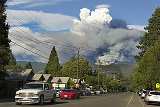
King Fire

Last updated

King Fire
King Fire 2014 (15407964766).jpg
A USFS firefighter watches the King Fire torching trees near Pollock Pines on September 14, 2014
Date(s)
  • September 13, 2014 (2014-09-13)
  • October 9, 2014 (2014-10-09)
Location El Dorado County, California
Coordinates 38°46′55″N120°36′14″W / 38.782°N 120.604°W / 38.782; -120.604
Statistics [1] [2] [3]
Burned area97,717 acres (39,545 ha; 153 sq mi; 395 km2)
Impacts
Deaths0
Non-fatal injuries12
Evacuated2,830
Structures destroyed
  • 12 residences
  • 68 outbuildings
Damage
  • $117 million
  • (equivalent to about $148 million in 2023)
Ignition
Cause Arson
Map
2014 King Fire map 1.png
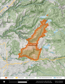
The footprint of the King Fire, west of Lake Tahoe and north of U.S. Route 50
USA California location map.svg
FireIcon.svg
Location of fire in Northern California

The 2014 King Fire was a large wildfire in El Dorado County, California, which burned 97,717 acres (39,545 hectares) primarily in the Eldorado National Forest. The wildfire started on September 13, 2014, near Pollock Pines, California, to the east of Sacramento. The ensuing fire suppression effort, which cost more than $100 million and engaged more than 8,000 personnel at its peak, allowed for the full containment of the King Fire by October 9, 2014. Despite the size and ferocity of the fire, it caused no deaths. Eighty structures were destroyed, the majority of them outbuildings. The King Fire was determined to have been caused by an act of arson and a suspect was swiftly apprehended and convicted in 2016.

Contents

Background

Much of the Eldorado National Forest where the King Fire burned had no recent fire history. The last major wildfire there had been the Cleveland Fire in 1992, which burned roughly 22,500 acres (9,100 ha). [4] [5]

Progression

The King Fire began on Saturday, September 13, 2014. [6] It was ignited by an act of arson along King of the Mountain Road—from which the fire got its name—in Pollock Pines, a small community along U.S. Route 50 in the western Sierra Nevada between Sacramento and Lake Tahoe. [7]

On September 16, three days after starting, the fire had spread to 11,520 hectares (115.2 km2), forcing the evacuation of over five hundred homes. [8] A handcrew of ten inmates and a fire captain were saved from being overrun when they were led to safety by a helicopter that was staged at the nearby Swansboro Country Airport. [9]

On September 17, the fire underwent a rapid expansion, pushing forward 15 miles (24 km) and burning an additional 50,000 acres (20,000 ha). [6] Firebrands and embers created spot fires more than three miles (4.8 km) downwind of the main fire. [4] California governor Jerry Brown declared a state of emergency in El Dorado County, citing the fire's threat to water and power infrastructure. [10]

By September 18, the fire had expanded to 73,184 acres (29,617 ha), becoming the second largest wildfire of the 2014 California wildfire season. [10] [11]

By the start of October the fire had grown to 97,099 acres (39,295 ha) with containment increasing to 94%. [11] On October 9, the perimeter of the King Fire was reported to be 100% contained, with a final acreage of 97,717 acres (39,545 ha). [3] [12] The U.S. Forest Service calculated the total cost of fighting the King Fire at approximately $117 million. [6]

Cause

The firefighters first on scene detected multiple points of origin for the King Fire, leading the El Dorado County District Attorney’s Office to swiftly conclude that arson had been the cause. Within days, witnesses came forward and disclosed that they had encountered Wayne Huntsman, a Pollock Pines resident and former inmate firefighter, near the scene of the fire's origin. Huntsman had told two of them "You better get home. Your house is going to burn down." After being given a ride near the fire, Huntsman had shown another man a 'selfie' video of himself in the forest, surrounded by flames. The man recorded Huntsman's video and submitted the information to authorities. [7]

On September 18, 2014, Wayne Huntsman was arrested on suspicion of intentionally starting the fire. [1] [13] He initially pled not guilty to the charges, [14] but in April 2016 pled guilty to arson. He was sentenced to 20 years in prison, the maximum allowable sentence, and ordered to pay $60 million in restitution by an El Dorado County Superior Court judge. [15] [16]

Effects

The King Fire injured a total of twelve people. [17] It destroyed 12 residences and 68 other structures. [6]

Closures and evacuations

The King Fire threatened hydroelectric infrastructure and recreation areas throughout the Sierra Nevada west of Tahoe. The U.S. Forest Service closed trails to the Desolation Wilderness from the Eldorado National Forest on September 11. [18] The total number of evacuees reached 2,830. [6]

Environmental impacts

The King Fire produced copious amounts of smoke, pushing parts of Placer, El Dorado, Nevada, and Amador counties into unhealthy-to-hazardous ranges of PM2.5 air pollution. Officials temporarily deployed emergency air-quality sensors throughout the Sierra. [19]

Growth and containment

Fire containment status Gray: contained; Red: active; %: percent contained;
DateArea burned in acres (ha)PersonnelContainment
Sep 13.........
Sep 14 [20] 3,000 acres (1,214 ha)806 personnel
10%
Sep 15 [21] 8,600 acres (3,480 ha)1,477 personnel
5%
Sep 16 [22] 12,780 acres (5,172 ha)2,466 personnel
5%
Sep 17 [23] 27,930 acres (11,303 ha)3,367 personnel
5%
Sep 18 [24] 73,184 acres (29,617 ha)3,842 personnel
10%
Sep 19 [25] 76,376 acres (30,908 ha)4,936 personnel
10%
Sep 20 [26] 80,944 acres (32,757 ha)4,901 personnel
10%
Sep 21 [27] 82,018 acres (33,192 ha)5,557 personnel
17%
Sep 22.........
Sep 23.........
Sep 24 [28] 92,960 acres (37,620 ha)7,952 personnel
38%
Sep 25 [29] 95,347 acres (38,586 ha)8,061 personnel
55%
Sep 26 [30] 97,099 acres (39,295 ha)7,214 personnel
74%
Sep 27 [31] 97,099 acres (39,295 ha)5,863 personnel
84%
Sep 28 [32] 97,099 acres (39,295 ha)4,878 personnel
87%
Sep 29 [33] 97,099 acres (39,295 ha)3,401 personnel
92%
Sep 30 [34] 97,099 acres (39,295 ha)2,364 personnel
94%
Oct 1 [35] 97,099 acres (39,295 ha)2,557 personnel
94%
Oct 2 [36] 97,718 acres (39,545 ha)2,451 personnel
95%
Oct 3 [37] 97,717 acres (39,545 ha)2,382 personnel
98%
Oct 4 [38] 97,717 acres (39,545 ha)2,095 personnel
98%
Oct 5 [39] 97,717 acres (39,545 ha)1,904 personnel
98%
Oct 6 [40] 97,717 acres (39,545 ha)1,734 personnel
98%
Oct 7 [41] 97,717 acres (39,545 ha)1,734 personnel
98%
Oct 897,717 acres (39,545 ha)......
Oct 997,717 acres (39,545 ha)...
100%

See also

Related Research Articles

<span class="mw-page-title-main">2009 California wildfires</span> Wildfire season

The 2009 California wildfires were a series of 9,159 wildfires that were active in the US state of California, during the year 2009. The fires burned more than 422,147 acres of land from early February through late November, due to Red Flag conditions, destroying hundreds of structures, injuring 134 people, and killing four. The wildfires also caused at least US$134.48 million in damage. Although the fires burned many different regions of California in August, the month was especially notable for several very large fires which burned in Southern California, despite being outside of the normal fire season for that region.

<span class="mw-page-title-main">Station Fire (2009)</span> 2009 wildfire in Southern California

The Station Fire was the largest wildfire of the 2009 California wildfire season, as well as the largest wildfire in the history of Los Angeles County, that burned in the Angeles National Forest, igniting on August 26, 2009, near the U.S. Forest Service Angeles Station 11 ranger station on the Angeles Crest Highway. The blaze threatened 12,000 structures in the National Forest and the nearby communities of La Cañada Flintridge, Pasadena, Glendale, Acton, La Crescenta, Juniper Hills, Littlerock and Altadena, as well as the Sunland and Tujunga neighborhoods of the City of Los Angeles. Many of these areas faced mandatory evacuations as the flames drew near, but as of September 6, all evacuation orders were lifted. The Station Fire burned on the slopes of Mount Wilson, threatening numerous television, radio and cellular telephone antennas on the summit, as well as the Mount Wilson Observatory, which includes several historically significant telescopes and multimillion-dollar astronomical facilities operated by UCLA, USC, UC Berkeley and Georgia State University.

<span class="mw-page-title-main">Rim Fire</span> 2013 wildfire in Central California

The Rim Fire was a massive wildfire that started in a remote canyon in the Stanislaus National Forest in California's Tuolumne County. The fire ignited on August 17, 2013, amid the 2013 California wildfire season, and burned 257,314 acres in largely remote areas of the Sierra Nevada, including a large portion of Yosemite National Park. The Rim Fire was fully contained on Thursday, October 24, 2013, after a nine-week suppression effort by firefighters. Due to a lack of winter rains, some logs smoldered in the interior portion of the fire footprint throughout the winter, and more than a year passed before the fire was declared totally extinguished in November 2014.

<span class="mw-page-title-main">2015 California wildfires</span> Wildfire season

The 2015 California wildfire season was a series of wildfires that burned across the state of California. By the end of 2015 a total of 8,745 fires were recorded, burning 893,362 acres (3,615 km2) across the state. Approximately 3,159 structures were damaged or destroyed by wildfires, and at least 7 fatalities were recorded.

<span class="mw-page-title-main">Rough Fire</span> 2015 wildfire in Central California

The Rough Fire was a major wildfire in Fresno County, California, and the largest of the 2015 California wildfire season. The fire was ignited by a lightning strike on July 31 and burned 151,623 acres (61,360 ha), largely in the Sierra National Forest and the Sequoia National Forest, before it was declared contained on November 6, 2015. At the time it occurred, the fire was the thirteenth largest in recorded California history.

<span class="mw-page-title-main">2016 California wildfires</span> An overview of major wildfires in California during the year 2016

In 2016, a total of 7,349 fires had burned an area 669,534 acres (2,709.51 km2) in California, according to the California Department of Forestry and Fire Protection.

<span class="mw-page-title-main">Young Fire</span> 2017 wildfire in Northern California

The Young Fire was a wildfire in the Siskiyou Wilderness in California in the United States. The fire was reported on August 7, 2017. The cause of the fire is currently unknown. As of August 28, the fire had burned 2,650 acres (11 km2) and been added to the Eclipse Complex Fires. By September 1, the Young Fire entirely merged into the Oak Fire.

<span class="mw-page-title-main">Cranston Fire</span> 2018 wildfire in Southern California

The Cranston Fire was a wildfire that burned in southwest Riverside County, California, in the United States. The fire was started on July 25, 2018, by Brandon M. McGlover, in an act of arson. The fire burned a total of 13,139 acres (53 km2), before it was fully contained on August 10. The Cranston Fire impacted the communities of Idyllwild and Mountain Center, as well as recreational activities in the Lake Hemet area, San Bernardino National Forest and Mount San Jacinto State Park. Over 7,000 people were evacuated due to the Cranston Fire.

<span class="mw-page-title-main">Mendocino Complex Fire</span> 2018 wildfire in Northern California

The Mendocino Complex Fire was a large complex of wildfires that burned in northern California for more than three months in 2018. It consisted of two wildfires, the River Fire and Ranch Fire, which burned in Mendocino, Lake, Colusa, and Glenn Counties in the U.S. State of California, with the Ranch Fire being California's single-largest recorded wildfire at the time until the Dixie Fire in 2021. The Ranch Fire burned eight miles northeast of Ukiah, and the River Fire burned six miles north of Hopland, to the south of the larger Ranch Fire. First reported on July 27, 2018, both fires burned a combined total of 459,123 acres (1,858 km2), before they were collectively 100% contained on September 18, though hotspots persisted until the complex was fully brought under control on January 4, 2019. The Ranch Fire alone burned 410,203 acres (1,660 km2), making it the largest wildfire in modern California history at the time until the August Complex fire that occurred in 2020. The Ranch Fire also surpassed the size of the 315,577-acre Rush Fire, which burned across California and Nevada, as well as the Santiago Canyon Fire of 1889, which was previously believed to have been California's all-time largest wildfire. It also included the Redwood Valley Fire that claimed 8 lives.
<span class="mw-page-title-main">Walker Fire (2019)</span> 2019 wildfire in Northern California

The Walker Fire was a wildfire that burned near Genesee Valley in the Plumas National Forest approximately 11 miles east of the community of Taylorsville in Plumas County, California. The blaze was reported on Wednesday, September 4, 2019 and immediately expanded in size over its several days of burning. The fire actively threatened homes from Genesee Valley to Antelope Road.

<span class="mw-page-title-main">Taboose Fire</span> 2019 wildfire in Eastern California

The Taboose Fire was a wildfire burning in Inyo National Forest, southwest of Big Pine and northwest of Aberdeen in Inyo County in the state of California, in the United States. The fire started September 4, 2019 and on October 7, it had burned 10,296 acres (4,167 ha) and was 75 percent contained. The cause of the fire was lightning. Select trails, campgrounds and roads in Inyo National Forest, Sequoia National Park and Kings Canyon National Park had been closed due to the fire. The community of Baxter Ranch was under mandatory evacuation.

<span class="mw-page-title-main">Lake Fire (2020)</span> 2020 wildfire in Southern California

The Lake Fire was a wildfire that burned during the 2020 California wildfire season in the Angeles National Forest in Los Angeles County in the state of California in the United States. The fire, which was first reported on August 12, 2020, burned 31,089 acres (12,581 ha) near Lake Hughes. It was fully contained on September 28. The cause of the fire remains unknown. The fire has damaged 3 structures, destroyed 12 structures and 21 outbuildings, and injured 4 firefighters.

<span class="mw-page-title-main">Loyalton Fire</span> 2020 wildfire in California and Nevada

The 2020 Loyalton Fire was a large wildfire in Lassen, Plumas and Sierra counties in California and Washoe County in Nevada. After it was ignited by lightning on August 14, 2020, the fire burned 47,029 acres (19,032 ha) in the Tahoe National Forest and the Humboldt-Toiyabe National Forest before it was fully contained on August 26. The Loyalton Fire was notable for generating three fire tornadoes on August 15, necessitating first-of-their-kind warnings by the National Weather Service.

<span class="mw-page-title-main">Creek Fire (2020)</span> 2020 wildfire in Central California

The 2020 Creek Fire was a very large wildfire in central California's Sierra National Forest, in Fresno and Madera counties. One of the most significant fires of California's record-setting 2020 wildfire season, it began on September 4, 2020, and burned 379,895 acres (153,738 ha) over several months until it was declared 100% contained on December 24, 2020. The Creek Fire is the fifth-largest wildfire in recorded California history and the second-largest single fire—i.e. not part of a larger wildfire complex—following the 2021 Dixie Fire.

<span class="mw-page-title-main">North Complex Fire</span> 2020 wildfire in Northern California

The North Complex Fire was a massive wildfire complex that burned in the Plumas National Forest in Northern California in the counties of Plumas and Butte. 21 fires were started by lightning on August 17, 2020; by September 5, all the individual fires had been put out with the exception of the Claremont and Bear Fires, which merged on that date, and the Sheep Fire, which was then designated a separate incident. On September 8, strong winds caused the Bear/Claremont Fire to explode in size, rapidly spreading to the southwest. On September 8, 2020, the towns of Berry Creek and Feather Falls were immediately evacuated at 3:15 p.m. PDT with no prior warning, By September 9, 2020, the towns of Berry Creek and Feather Falls had been leveled, with few homes left standing. The fire threatened the city of Oroville, before its westward spread was stopped. The fire killed 16 people and injured more than 100. Among the 16 fatalities was a 16-year-old boy. The complex burned an estimated 318,935 acres (129,068 ha), and was 100% contained on December 3. The fire was managed by the U.S. Forest Service in conjunction with Cal Fire, with the primary incident base in Quincy. The North Complex Fire was the sixth-largest in California's modern history, and the deadliest fire in the 2020 California wildfire season.

<span class="mw-page-title-main">El Dorado Fire</span> 2020 wildfire in Southern California

The El Dorado Fire was a wildfire that burned 22,744 acres in San Bernardino and Riverside counties of California from September to November 2020. It was ignited on September 5 by a pyrotechnic device at a gender reveal party in El Dorado Ranch Park; it quickly spread to the San Gorgonio Wilderness Area of the San Bernardino National Forest. Burning over a 71-day period, the fire destroyed 20 structures and resulted in one firefighter fatality, for which the couple hosting the party were charged with involuntary manslaughter.
<span class="mw-page-title-main">Salt Fire (2021)</span> 2021 wildfire in Northern California

The Salt Fire was a wildfire that burned 12,660 acres (5,123 ha) in the Lakehead area north of Shasta Lake in Shasta County, California in the United States during the 2021 California wildfire season. The fire was first reported on Wednesday, June 30, 2021, and it was fully contained on July 19, 2021. The fire destroyed forty-one structures, including twenty-seven residences and fourteen outbuildings, and damaged four additional outbuildings. Although the cause remains under investigation, officials from the Shasta–Trinity National Forest believe that the fire was likely sparked by hot material that fell from a vehicle on Interstate 5 and landed in dry brush next to the freeway.

<span class="mw-page-title-main">McFarland Fire</span> 2021 wildfire in Northern California

The McFarland Fire was a wildfire that burned in the Shasta-Trinity National Forest north of Wildwood in Trinity County, Shasta County, and Tehama County, California in the United States. Started by a lightning strike, the fire was first reported on July 29, 2021 on McFarland Ridge south of Highway 36. As of September 16, 2021, the fire had burned 122,653 acres (49,636 ha) and destroyed 46 structures.

<span class="mw-page-title-main">Caldor Fire</span> 2021 wildfire in Northern California

The Caldor Fire was a large wildfire that burned 221,835 acres in the Eldorado National Forest and other areas of the Sierra Nevada in El Dorado, Amador, and Alpine County, California, in the United States during the 2021 California wildfire season. The fire was first reported on Saturday, August 14, 2021, and was fully contained on Thursday, October 21, 2021. The Caldor Fire destroyed 1,005 structures and damaged 81 more, primarily in the US Highway 50 corridor and in the community of Grizzly Flats, 2/3 of which was destroyed by the fire.

<span class="mw-page-title-main">Mosquito Fire</span> 2022 wildfire in Northern California

The Mosquito Fire was California's largest wildfire of 2022, burning in the American River watershed in Placer and El Dorado counties in Northern California. The fire began on September 6 amid a state-wide heat wave and went on to burn 76,788 acres, primarily in the Tahoe and Eldorado National Forests, while also destroying 78 structures in the rural communities of Michigan Bluff, Foresthill, and Volcanoville. Authorities declared the fire fully contained on October 22 following several storms. The fire suppression effort cost more than $180 million, and at its peak involved more than 3,700 firefighters. The precise cause of the fire is not known, but the potential role of Pacific Gas & Electric Company (PG&E) equipment is the subject of multiple civil lawsuits and a Forest Service investigation. The Mosquito Fire was one of 7,477 total wildfires in California in 2022, which burned a combined 331,358 acres (134,096 ha).

References

  1. 1 2 Rocha, Veronica; Xia, Rosanna (September 18, 2014). "Man arrested on suspicion of arson in out-of-control King fire". Los Angeles Times. Retrieved September 21, 2014.
  2. "Giant King fire burns 10 homes, could be whipped up as weather shifts". Los Angeles Times. September 21, 2014. Retrieved September 22, 2014.
  3. 1 2 "King Fire". InciWeb. Retrieved September 21, 2014.
  4. 1 2 Rocha, Veronica; Xia, Rosanna (September 18, 2014). "Massive King fire sets off even louder alarms in California". Los Angeles Times . Archived from the original on January 19, 2024. Retrieved February 20, 2024.
  5. "King fire burns more than 80,000 acres in Northern California". Los Angeles Times . September 20, 2014. Archived from the original on February 24, 2016. Retrieved February 21, 2024.
  6. 1 2 3 4 5 "King Fire Facts" (PDF). www.fs.usda.gov. Eldorado National Forest. Archived (PDF) from the original on July 26, 2022. Retrieved February 20, 2024.
  7. 1 2 Wang, Yanan (April 11, 2016). "The telltale selfie that nailed the man responsible for California's epic King fire". The Washington Post . Archived from the original on October 26, 2021. Retrieved February 20, 2024.
  8. "King Fire in El Dorado County". Sacramento Bee. Retrieved September 21, 2014.
  9. Megna, Dan (2015). "1600 Yards to Freedom". Vertical Magazine, Heli-Expo news. p. 46. Archived from the original on April 19, 2015. Retrieved April 11, 2015.
  10. 1 2 Berman, Mark (September 19, 2014). "Massive King fire in California continues to grow". The Washington Post . Archived from the original on June 8, 2023. Retrieved February 21, 2024.
  11. 1 2 "King Fire General Information". Cal Fire. Archived from the original on July 1, 2015. Retrieved September 21, 2014.
  12. Flores, Adolfo (October 9, 2014). "97,000-acre King fire is fully contained, officials say". Los Angeles Times . Archived from the original on June 1, 2016. Retrieved February 21, 2024.
  13. York, Jessica A. (September 19, 2014). "King Fire arson suspect is former Santa Cruz man". Santa Cruz Sentinel. Retrieved February 17, 2023 via Mercury News.
  14. "King Fire arson suspect pleads not guilty". Sacramento: KXTV. September 20, 2014. Archived from the original on October 6, 2014.
  15. "Wayne Allen Huntsman Sentenced to 20 Years For Setting King Fire". CBS News Sacramento. April 8, 2016. Retrieved February 17, 2023.
  16. Vives, Ruben (April 8, 2016). "King fire arsonist who took selfie video pleads guilty". Los Angeles Times . Archived from the original on October 1, 2019. Retrieved February 21, 2024.
  17. "Massive King fire still rages, could be whipped up as weather changes". Los Angeles Times. September 21, 2014. Archived from the original on September 25, 2020. Retrieved February 20, 2024.
  18. Weiser, Matt (September 18, 2014). "King Fire affects hydroelectric facilities, recreation areas". The Sacramento Bee . Archived from the original on February 21, 2024. Retrieved February 21, 2024.
  19. Weiser, Matt (September 19, 2014). "Smoke from King fire reaches 'hazardous' levels". The Sacramento Bee . Archived from the original on February 21, 2024. Retrieved February 21, 2024.
  20. "King Fire Update September 14 PM". InciWeb . September 14, 2014. Archived from the original on May 16, 2017.
  21. "King Fire Update September 15 PM". InciWeb . September 15, 2015. Archived from the original on May 16, 2017.
  22. "King Fire Update September 16 PM". InciWeb . September 16, 2014. Archived from the original on May 16, 2017.
  23. "King Fire Update September 17 PM". InciWeb . September 17, 2014. Archived from the original on May 16, 2017.
  24. "King Fire Update September 18 PM". InciWeb . September 18, 2014. Archived from the original on May 16, 2017.
  25. "King Fire Update September 19 Pm". InciWeb . September 19, 2014. Archived from the original on September 18, 2015.
  26. "King Fire Update September 20 AM". InciWeb . September 20, 2014. Archived from the original on May 5, 2017.
  27. "King Fire Update September 21 Pm". InciWeb . September 22, 2014. Archived from the original on April 3, 2016.
  28. "King Fire Update September 24 PM". InciWeb . September 24, 2014. Archived from the original on May 23, 2017.
  29. "King Fire Update September 25 PM". InciWeb . September 25, 2014. Archived from the original on May 23, 2017.
  30. "King Fire Updates September 26 PM". InciWeb . September 26, 2014. Archived from the original on May 23, 2017.
  31. "King Fire Update September 27 PM". InciWeb . September 27, 2014. Archived from the original on May 23, 2017.
  32. "King Fire Update September 28 AM". InciWeb . September 28, 2014. Archived from the original on May 23, 2017.
  33. "King Fire evening Update 9-29-14". InciWeb . September 29, 2014. Archived from the original on May 23, 2017.
  34. "King Fire evening update 9-30-14". InciWeb . September 30, 2014. Archived from the original on May 23, 2017.
  35. "King Fire evening update - Oct 1, 2014". InciWeb . October 1, 2014. Archived from the original on May 23, 2017.
  36. "King Fire evening update Oct 2". InciWeb . October 2, 2014. Archived from the original on May 23, 2017.
  37. "King Fire evening update Oct 3, 2014". InciWeb . October 3, 2014. Archived from the original on May 23, 2017.
  38. "King Fire evening update Oct 4". InciWeb . October 4, 2014. Archived from the original on May 23, 2017.
  39. "King Fire evening update Oct 5, 2014". InciWeb . October 5, 2014. Archived from the original on May 23, 2017.
  40. "King Fire evening update Oct 6". InciWeb . October 6, 2014. Archived from the original on May 23, 2017.
  41. "King Fire morning update Oct 7". InciWeb . October 7, 2014. Archived from the original on May 23, 2017.