
The Harris Fire was a major wildfire in southern San Diego County, California, that began on October 21, 2007, which burned 90,440 acres (366.0 km2) before it was contained on November 5. Hotspots persisted until the fire was extinguished on November 16, making the Harris Fire the last of the October 2007 California wildfires to be extinguished. As the Harris Fire burned, it traveled in a northwest direction from its starting point at Harris Ranch Road in the town of Potrero, located in the far south of San Diego County, near Tecate, Mexico. The wildfire was the second-largest one of the October 2007 California wildfires, behind only the Witch Fire. The cause of the Harris Fire is unknown. The Harris Fire was the deadliest one of the October 2007 wildfires, killing eight people.

The 2009 California wildfires were a series of 9,159 wildfires that were active in the US state of California, during the year 2009. The fires burned more than 422,147 acres of land from early February through late November, due to Red Flag conditions, destroying hundreds of structures, injuring 134 people, and killing four. The wildfires also caused at least US$134.48 million in damage. Although the fires burned many different regions of California in August, the month was especially notable for several very large fires which burned in Southern California, despite being outside of the normal fire season for that region.

2014 saw several notable wildfires igniting in California, especially during the month of May, when multiple fires were ablaze concurrently in Southern California, and during September, when several massive wildfires were burning in Northern California. In the context of the 2012–13 North American drought, as well as powerful Santa Ana winds, weather conditions were ideal for wildfires. A total of 7,865 wildfires ignited throughout the year, which burned at least 625,540 acres (2,531.5 km2) of land. The wildfires caused a total of 146 injuries and 2 fatalities, in addition to causing at least $204.05 million in damage.

The October 2007 California wildfires, also known as the Fall 2007 California firestorm, were a series of about thirty wildfires that began igniting across Southern California on October 20. At least 1,500 homes were destroyed and approximately 972,147 acres of land was burned from Santa Barbara County to the U.S.–Mexico border, surpassing the October 2003 California wildfires in scope, which were estimated to have burned 800,000 acres (3,200 km2). The wildfires killed a total of 14 people, with nine of them dying directly from the fires; 160 others were injured, including at least 124 firefighters. At their height, the raging fires were visible from space. These fires included the vast majority of the largest and deadliest wildfires of the 2007 California wildfire season. The only wildfire in 2007 that surpassed any of the individual October 2007 fires in size was the Zaca Fire.

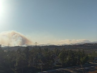
The Border Fire was a large wildfire that burned in Potrero, San Diego County, California, as part of the 2016 California wildfire season. The fire was so named due to its proximity to the United States-Mexican border.

The Creek Fire was a large wildfire that burned in Kagel Canyon and the Angeles National Forest north of Sylmar, a neighborhood in Los Angeles, California, United States, and one of multiple wildfires that broke out across Southern California in December 2017. The Creek Fire burned 15,619 acres (63 km2) and destroyed 123 structures, including 60 homes, before being contained on January 9, 2018, following heavy rainfall from a winter storm. The fire threatened the communities of Santa Clarita, Glendale, Olive View, Lake View Terrace, Sunland-Tujunga, Shadow Hills, Sylmar, Pacoima, Lopez Canyon, and Kagel Canyon, as well as the Olive View–UCLA Medical Center. During the wildfire, 115,000 residents were forced to evacuate their homes.
The Rye Fire was a wildfire that burned in Santa Clarita, California, in the United States, and one of multiple wildfires that broke out across Southern California in December 2017. The fire threatened over 5,000 structures, including Six Flags Magic Mountain, threatened the city of Santa Clarita and impacted traffic on Interstate 5. The Rye Fire burned a total of 6,049 acres (24.48 km2), before it was fully contained on December 12. The fire destroyed six buildings, including minor structures located at the Peter J. Pitchess Detention Center.

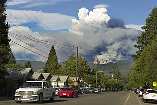
A series of 29 wildfires ignited across Southern California in December 2017. Six of the fires became significant wildfires, and led to widespread evacuations and property losses. The wildfires burned over 307,900 acres (1,246 km2), and caused traffic disruptions, school closures, hazardous air conditions, and power outages; over 230,000 people were forced to evacuate. The largest of the wildfires was the Thomas Fire, which grew to 281,893 acres (1,140.78 km2), and became the largest wildfire in modern California history, until it was surpassed by the Ranch Fire in the Mendocino Complex, in the following year.

The Lilac Fire was a fire that burned in northern San Diego County, California, United States, and the second-costliest one of multiple wildfires that erupted in Southern California in December 2017. The fire was first reported on December 7, 2017, burned 4,100 acres (1,659 ha), and destroyed 157 structures, before it was fully contained on December 16. The fire cost at least $8.9 million, including $5 million in firefighting expenses and property damage, and an additional $3.9 million in cleanup and erosion control costs. The fire threatened the communities of Bonsall, Oceanside, Vista, Fallbrook, and Camp Pendleton. During the fire, an estimated 10,000 residents were forced to evacuate, while a total of over 100,000 residents were forced to or advised to evacuate. On December 7, the Lilac Fire also cut the power to 20,000 people.

The Pawnee Fire was a large wildfire that burned in Spring Valley in Lake County, California, in the United States. The fire started on June 23, 2018, and quickly expanded overnight, destroying 12 structures, and causing the evacuation of the entire Spring Valley area. It destroyed 22 structures, damaged six structures, and burned a total of 15,185 acres (61 km2) before it was fully contained on July 8, 2018. A Cal Fire investigation determined in April 2019 the cause of the fire was target shooting.

The Carr Fire was a large wildfire that burned in Shasta and Trinity Counties in California, United States. The fire burned 229,651 acres, before it was 100% contained late on August 30, 2018. The Carr Fire destroyed at least 1,604 structures while damaging 277 others, becoming at the time the sixth-most destructive fire in California history, as well as the fourteenth-largest wildfire recorded in modern California history. The Carr Fire cost over $1.659 billion in damages, including $1.5 billion in insured losses and more than $158.7 million in suppression costs. The fire destroyed multiple towns around Whiskeytown Lake. At its height, the fire engaged as many as 4,766 personnel from multiple agencies. The fire was reported on the afternoon of July 23, 2018, near the intersection of Highway 299 and Carr Powerhouse Road, at mile marker 9, in the Whiskeytown district of the Whiskeytown–Shasta–Trinity National Recreation Area. Coincidental to the name of the incident, the fire was started when a flat tire on a vehicle caused the wheel's rim to scrape against the asphalt, creating sparks that set off the fire.
The Mendocino Complex Fire was a large complex of wildfires that burned in northern California for more than three months in 2018. It consisted of two wildfires, the River Fire and Ranch Fire, which burned in Mendocino, Lake, Colusa, and Glenn Counties in California, with the Ranch Fire being California's single-largest recorded wildfire at the time until the August Complex fire in 2020. The Ranch Fire burned eight miles northeast of Ukiah, and the River Fire burned six miles north of Hopland, to the south of the larger Ranch Fire. First reported on July 27, 2018, both fires burned a combined total of 459,123 acres (1,858 km2), before they were collectively 100% contained on September 18, though hotspots persisted until the complex was fully brought under control on January 4, 2019. The Ranch Fire alone burned 410,203 acres (1,660 km2), making it the largest wildfire in modern California history at the time until the August Complex fire that occurred in 2020. The Ranch Fire also surpassed the size of the 315,577-acre Rush Fire, which burned across California and Nevada, as well as the Santiago Canyon Fire of 1889, which was previously believed to have been California's all-time largest wildfire.

The Crews Fire was a wildfire that burned east of the city of Gilroy in Santa Clara County, California, in the United States. The fire started on July 5, 2020. It burned 5,513 acres (2,231 ha) and was extinguished on July 13, 2020. Burning approximately three miles east of Highway 101, the fire caused the evacuation approximately 20 homes and 70 residents. One structure was destroyed, one was damaged, and one firefighter was injured. It threatened 30 structures and farm and ranch lands in southeast Gilroy in the San Juan Valley. Mandatory evacuations were ordered on July 5, and they were lifted on July 8.
The Soledad Fire was a wildfire that burned 1,525 acres (617 ha) south of Agua Dulce and northeast of Santa Clarita in Los Angeles County, California in the United States during the 2020 California wildfire season. The fire started on July 5, 2020, and caused the complete closure of State Route 14 in both directions throughout the day as the fire grew to 1,498 acres. The fire also at a point threatened over 4,795 structures, although only 9 homes were formally threatened by the direct fireline. The cause of the fire is currently under investigation.

The Apple Fire was a wildfire that burned during the 2020 California wildfire season in Cherry Valley south of Oak Glen and north of Beaumont and Banning in Riverside County, California in the United States. The fire ignited on Friday, July 31, 2020 as three separate smaller blazes within the rural canyons along Oak Glen Road before merging and rapidly expanded to 1,900 acres (769 ha) and destroyed at least one home and two outbuildings in the Cherry Valley area. It now covers at least 33,424 acres (13,526 ha) and created "a plume of smoke so massive that it generated its own winds." The fire was sparked by a diesel-burning vehicle that emitted burning carbon. The fire was named after one of the roadways close to the ignition site, which is named Apple Tree Lane.

The LNU Lightning Complex fires were a large complex of wildfires that burned during the 2020 California wildfire season across much of the Wine Country area of Northern California – Lake, Napa, Sonoma, Solano, and Yolo Counties, from August 17 to October 2, 2020. The complex was composed of numerous lightning-sparked fires, most of which were small. While they ignited separately from each other, the Hennessey Fire eventually grew to merge with the Gamble, Green, Markley, Spanish, and Morgan fires, scorching 192,000 acres (777 km2) by itself, for a total burn area of 363,220 acres (1,470 km2) in the complex. The fire, which burned in the hills surrounding several large cities, such as Fairfield, Napa, and Vacaville, destroyed 1,491 structures and damaged a further 232. In all, six people were killed and another five injured. The LNU Lightning Complex is the seventh-largest wildfire in the recorded history of California.
The French Fire was a wildfire that burned 26,535 acres (10,738 ha) near Shirley Meadows west of Lake Isabella in Kern County, California in the United States during the 2021 California wildfire season. The fire was initially reported on Wednesday, August 18, 2021, and ended around October 24, 2021. The fire threatened the communities of Shirley Meadows, Alta Sierra and Wofford Heights. The fire reportedly destroyed some 18 structures, including 9 residences. The fire was determined, as of September 13, 2021, to have been human-caused and suspicious in nature.

The Fawn Fire was a destructive wildfire in Northern California's Shasta County, near Redding, in late September and early October 2021. The fire, which was caused by an alleged act of arson, ignited on September 22 in mountains to the northeast of Redding. High winds the following day drove the fire south and west into neighborhoods in the wildland-urban interface, where it destroyed 185 buildings and damaged 26 more. At least three firefighters were injured. The Fawn Fire cost more than $25 million to suppress and burned 8,578 acres before being fully contained on October 2. A woman was arrested the day of the Fawn Fire's ignition and charged with starting the fire. As of 2024, legal proceedings remained ongoing.
The Fairview Fire is a deadly and destructive wildfire that burned during the 2022 California wildfire season southwest of Valle Vista and east of Hemet in Riverside County, California in the United States. The fire ignited on September 5, 2022, during a severe heatwave that had plagued much of the southwest throughout early September and, due to the extreme weather conditions, grew to a deadly and destructive conflagration in the chaparral-filled foothills within just several hours of igniting.
The Mill Fire was a fast-moving, deadly and destructive wildfire that burned during the 2022 California wildfire season, destroying parts of the communities of Weed, Lake Shastina and Edgewood in Siskiyou County in the U.S. state of California. Igniting during hot, dry & windy conditions on September 2, 2022, amid a record-breaking heat wave that spanned much of the state, the Mill Fire moved rapidly to the north. Most of the fire's acreage burned and structures destroyed occurred on the first day, due to its predominantly wind-driven nature. The Mill Fire burned 3,935 acres, destroyed 118 structures, and damaged 26 more. The fire also caused 2 fatalities when two residents of Weed were unable to escape the quick-moving blaze in its first hours. The fire was fully contained on September 13, 2022.


