
Raisinville Township is a civil township of Monroe County in the U.S. state of Michigan. The population was 5,816 at the 2010 census.

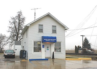
Newport is an unincorporated community in Monroe County in the U.S. state of Michigan. The community is located within Berlin Charter Township. As an unincorporated community, Newport has no legally defined boundaries or population statistics of its own but does have its own post office with the 48166 ZIP Code.

Oxbow is an unincorporated community in Baker County, Oregon, United States. Oxbow is along Oregon Route 86 next to the Snake River near the Oxbow Dam on the Oregon-Idaho border, about 17 miles (27 km) northeast of Halfway. Oxbow is just south of the site of the former mining town of Copperfield. Oxbow has a post office with a ZIP code 97840.
Weitchpec ( WETCH-pek is an unincorporated community within the Yurok reservation in Humboldt County, California, United States. It is located 35 miles northeast of Eureka, at an elevation of 361 feet. The ZIP Code is 95546.
Drewsey is an unincorporated community in Harney County, in the U.S. state of Oregon. Drewsey is along the main stem of the Malheur River, about 45 miles (72 km) east of Burns, off U.S. Route 20. It has the ZIP Code of 97904.

Somis is an unincorporated community in Ventura County, California. It was established in 1892 by Thomas Bard and D.T. Perkins on a portion of the Rancho Las Posas Mexican land grant. Somis is in the Las Posas Valley on the south bank of Fox Barranca, just west of Arroyo Las Posas. For statistical purposes, the United States Census Bureau has defined Somis as a census-designated place (CDP).

McMillan is an unincorporated community in Luce County in the U.S. state of Michigan. The community is located along M-28 within Columbus Township. As an unincorporated community, McMillan has no legally defined boundaries or population statistics of its own but does have its own post office with the 49853 ZIP Code.

Eureka is an unincorporated community and census-designated place (CDP) in Clinton County in the U.S. state of Michigan. The community is located within Greenbush Township. As an unincorporated community, Eureka has no legal autonomy of its own but does have its own post office with the 48833 ZIP Code.

Ottawa Lake is an unincorporated community in Monroe County in the U.S. state of Michigan. The community is located within Whiteford Township. As an unincorporated community, Ottawa Lake has no legally defined boundaries or population statistics of its own but does have its own post office with the 49267 ZIP Code.

Luzerne is an unincorporated community in Oscoda County in the U.S. state of Michigan. The community is located within Big Creek Township. As an unincorporated community, Luzerne has no legally defined boundaries or population statistics of its own but does have its own post office with the 48636 ZIP Code.
Samaria is an unincorporated community in Monroe County in the U.S. state of Michigan. The community is located within Bedford Township. As an unincorporated community, Samaria has no legally defined boundaries or population statistics of its own but does have its own post office with the 48177 ZIP Code.

Grovertown is an unincorporated community in southeastern Oregon Township, Starke County, in the U.S. state of Indiana.
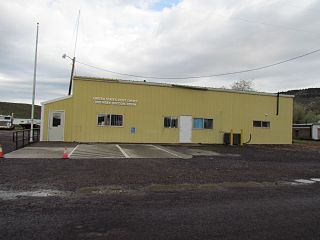
Lawen is an unincorporated community in Harney County, Oregon, United States. It has a post office with a ZIP code 97720. Lawen lies along Oregon Route 78 just south of its interchanges with Oregon Route 205, U.S. Route 20, and U.S. Route 395 in Burns, the county seat. Lawen is just north of the East Fork Silvies River and Malheur Lake.
Hereford is an unincorporated community in Baker County, in the U.S. state of Oregon. Hereford lies along the Burnt River southwest of Baker. It is on Oregon Route 245 northeast of its intersection with U.S. Route 26 in Unity. Hereford is 3,671 feet (1,119 m) above sea level.
Lime is an unincorporated community and ghost town in Baker County, Oregon, United States, 5 miles (8 km) north of Huntington on U.S. Route 30/Interstate 84. It is near the confluence of Marble Creek and the Burnt River on the Union Pacific Railroad. The Oregon Trail passes through Lime.

Fairfield Township is a civil township of Lenawee County in the U.S. state of Michigan. As of the 2000 census, the township population was 1,756.
Weatherby is an unincorporated community in Baker County, Oregon, United States. It is about 9 miles (14 km) southeast of Durkee on Interstate 84/U.S. Route 30, near the Burnt River.
Nelson is an unincorporated historic locale in Baker County, Oregon, United States. It is about 4 miles (6 km) southeast of Durkee on U.S. Route 30/Interstate 84.

Willow is an unincorporated community in Wayne County in the U.S. state of Michigan. The community is located within Huron Charter Township. As an unincorporated community, Willow has no legally defined boundaries or population statistics of its own.
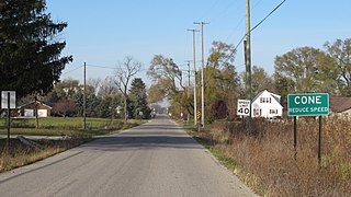
Cone is an unincorporated community in Monroe County in the U.S. state of Michigan. The community is located within Milan Township. As an unincorporated community, Cone has no legally defined boundaries or population statistics of its own.


