Pocahontas, Oregon

Last updated
Pocahontas, Oregon
USA Oregon location map.svg
Red pog.svg
Pocahontas, Oregon
Usa edcp location map.svg
Red pog.svg
Pocahontas, Oregon
Coordinates: 44°48′52″N117°58′20″W / 44.81444°N 117.97222°W / 44.81444; -117.97222 Coordinates: 44°48′52″N117°58′20″W / 44.81444°N 117.97222°W / 44.81444; -117.97222
Country United States
State Oregon
County Baker
Elevation
3,674 ft (1,120 m)
Time zone UTC-8 (Pacific (PST))
  Summer (DST) UTC-7 (PDT)
GNIS feature ID1125494 [1]

Pocahontas is a historic former community [1] in Baker County, Oregon, United States. It lies northwest of Baker City along Pocahontas Road near the Elkhorn Mountains. [2]

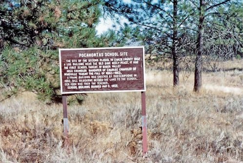
The town was named after Pocahontas, a famous Native American woman. [3] According to Oregon Geographic Names, which cites Thirty-One Years in Baker County, an unknown number of people laid out a town called Pine City in the 1860s near the base of the mountains. Pine City, probably founded in 1862, was along Pine Creek and was meant to serve as a place of accommodation for miners and others traveling through the region. Meanwhile, John McClain, a rancher who lived nearby, established Pocahontas and persuaded the people of Pine City to move there. [3]

Pocahontas, also meant as a traveler's resting stop, soon had a hotel, blacksmith shop, and express office. It set up a post office on August 4, 1863, with Thomas McMurran as postmaster. The year of the post-office closing is in doubt, either 1864 or 1872. [3]

Related Research Articles

Oxbow, Oregon unincorporated community in Oregon, United States

Oxbow is an unincorporated community in Baker County, Oregon, United States. Oxbow is along Oregon Route 86 next to the Snake River near the Oxbow Dam on the Oregon-Idaho border, about 17 miles (27 km) northeast of Halfway. Oxbow is just south of the site of the former mining town of Copperfield. Although it is unincorporated, Oxbow has a post office with a ZIP code of 97840.

Twin Rocks, Oregon Unincorporated community in Oregon, United States

Twin Rocks is an unincorporated community in Tillamook County, Oregon, United States, on the Oregon Coast. Twin Rocks, founded as a summer resort community, was named for two offshore rocks, 100 feet (30 m) high, in the Pacific Ocean. Twin Rocks post office was established in 1914, with William E. Dunsmoor as the first postmaster. The post office closed in 1954.

Andrews, Oregon Ghost town in Oregon, United States

Andrews is a ghost town in Harney County, Oregon, United States. It is located south of Steens Mountain and near the Alvord Desert.

Whitney, Oregon Unincorporated community in Oregon, United States

Whitney is an unincorporated community, also considered a ghost town, in Baker County, Oregon, United States, on Oregon Route 7 southwest of Sumpter. It is on the North Fork Burnt River, near the Blue Mountains and Wallowa-Whitman National Forest.

Copperfield, Oregon Former unincorporated community in Oregon, United States

Copperfield is a former town in Baker County, in the U.S. state of Oregon. It is on the west bank of the Snake River and the north bank of Pine Creek, downstream of a feature of the Snake River known as The Oxbow. Copperfield Park, managed by Idaho Power, occupies the former town site. The Geographic Names Information System also lists Copperfield as a variant name for Oxbow, Oregon.

New Pine Creek, Oregon Unincorporated community & census-designated place in Oregon, United States

New Pine Creek is a census-designated place and unincorporated community in Lake County, Oregon, United States. Although it is unincorporated, it has a post office with a ZIP code of 97635. New Pine Creek lies on U.S. Route 395 at the Oregon–California border, just north of New Pine Creek, California, and east of Goose Lake.

Auburn, Oregon Former unincorporated community in Oregon, United States

Auburn was an unincorporated community in rural Baker County, Oregon, United States, now considered a ghost town. Auburn lies off Oregon Route 7 southwest of Baker City and east of McEwen on the edge of the Blue Mountains.

Wingville, Oregon Unincorporated community in Oregon, United States

Wingville is an unincorporated community in Baker County, Oregon, United States. Wingville lies at the intersection of Wingville Lane and Old Wingville Road northwest of Baker City and northeast of Pocahontas.

Hereford, Oregon Unincorporated community in Oregon, United States

Hereford is an unincorporated community in Baker County, in the U.S. state of Oregon. Hereford lies along the Burnt River southwest of Baker. It is on Oregon Route 245 northeast of its intersection with U.S. Route 26 in Unity. Hereford is 3,671 feet (1,119 m) above sea level.

New Princeton, Oregon Unincorporated community in Oregon, United States

New Princeton is an unincorporated community in Harney County, in the U.S. state of Oregon. It is along Oregon Route 78 between Burns and Burns Junction at an elevation of 4,111 feet (1,253 m) above sea level. The South Fork Malheur River begins near Round Mountain, southeast of New Princeton.

Salisbury, Oregon Unincorporated community in Oregon, United States

Salisbury is an unincorporated historic community in Baker County, Oregon, United States. It lies along the Powder River at the junction of Oregon Route 7 and Oregon Route 245 about 10 miles (16 km) southwest of Baker City. The elevation is 3,655 feet (1,114 m).

Sparta, Oregon Unincorporated community in Oregon, United States

Sparta is an unincorporated community in Baker County, Oregon, United States. It was named for Sparta, Illinois, by William H. Packwood, a prominent Oregon pioneer who visited the gold diggings at the Powder River there in 1871.

Bourne, Oregon Former unincorporated community in Oregon, United States

Bourne is a ghost town in Baker County, Oregon, United States about 7 miles (11 km) north of Sumpter in the Blue Mountains. It lies on Cracker Creek and is within the Wallowa–Whitman National Forest. Platted in 1902, the former gold mining boomtown is considered a ghost town today.

Carson, Oregon Unincorporated community in Oregon, United States

Carson is an unincorporated community in Baker County, in the U.S. state of Oregon, along Oregon Route 413 about 5 miles (8 km) northwest of Halfway. In 1870 Tom Corson settled in the area on a tributary of Pine Creek. His neighbors pronounced his name "Carson" and named the tributary and a sawmill on the creek after him. When the post office was established in 1893, it was named "Carson" as well. The town was platted in 1900, the first in Pine Valley. The platted area was small even by northeastern standards: 12 blocks. Carson lost out as a rural service center to the nearby Langrell.

Robinette, Oregon Former unincorporated community in Oregon, United States

Robinette is a former unincorporated community in Baker County, Oregon, United States.

Dixie, Baker County, Oregon Unincorporated community in Oregon, United States

Dixie is an unincorporated community in Baker County, Oregon, United States. It is along the Burnt River about 5 miles (8 km) north of Lime. Dixie was so-named because it is near the confluence of the Burnt River and Dixie Creek, which in turn was named for the many gold miners from the U.S. South who worked on the creek. Dixie post office was opened in 1913 and closed in 1924. The post office was near the railroad along the Burnt River rather than in the mining area.

Weatherby, Oregon Unincorporated community in Oregon, United States

Weatherby is an unincorporated community in Baker County, Oregon, United States. It is about 9 miles (14 km) southeast of Durkee on Interstate 84/U.S. Route 30, near the Burnt River.

Pleasant Valley, Baker County, Oregon Unincorporated community in Oregon, United States

Pleasant Valley is an unincorporated community in Baker County, Oregon, United States. It is about 13 miles (21 km) southeast of Baker City on U.S. Route 30, slightly bypassed by Interstate 84.

Rye Valley, Oregon Unincorporated community in Oregon, United States

Rye Valley is an unincorporated community in Baker County, in the U.S. state of Oregon. It lies along Dixie Creek, a tributary of the Burnt River, about 30 miles (48 km) southeast of Baker City. It is slightly west of Interstate 84 near Weatherby and Dixie.

Quartz Mountain, Oregon Unincorporated community in Oregon, United States

Quartz Mountain is an unincorporated community in Lake County in the U.S. state of Oregon. It lies in the Fremont–Winema National Forest along Oregon Route 140 between Bly and Lakeview. Quartz Creek, a tributary of Drews Creek, which feeds Goose Lake, flows through the community.

References

  1. 1 2 "Pocahontas". Geographic Names Information System. United States Geological Survey. November 28, 1980. Retrieved November 5, 2016.
  2. Oregon Atlas & Gazetteer (7th ed.). Yarmouth, Maine: DeLorme. 2008. p. 79. ISBN   978-0-89933-347-2.
  3. 1 2 3 McArthur, Lewis A.; McArthur, Lewis L. (2003) [1928]. Oregon Geographic Names (7th ed.). Portland, Oregon: Oregon Historical Society Press. pp. 771–72. ISBN   978-0875952772.