Quamby Bluff

Last updated

Quamby Bluff
Quamby Bluff, tasmania.JPG
Quamby Bluff
Highest point
Elevation 1,227 [note 1]  m (4,026 ft)AHD [1]
Prominence 494 m (1,621 ft) [2]
Coordinates 41°39′37″S146°43′20″E / 41.66028°S 146.72222°E / -41.66028; 146.72222 [3]
Geography
Relief Map of Tasmania.png
Red triangle with thick white border.svg
Quamby Bluff
Location in Tasmania, Australia
Location Tasmania, Australia
Parent range Great Western Tiers
Topo map TASMAP 1:25,000 Quamby Bluff

Quamby Bluff is a mountain in Northern Tasmania, Australia that is an outlying part of the Great Western Tiers mountain range.

Contents

Geography and Geology

Quamby Bluff lies 19 kilometres (12 mi) from Deloraine by road, just north of the main escarpment of the Great Western Tiers mountain range. [4] The name Quamby has been variously stated to be derived from Quarmby, the district in Huddersfield Yorkshire, or from a Viking word that means "mill farm", though most likely from local Tasmanian languages meaning either a "place of rest" or a "good camping place". [5] Daniel Bunce in his 1859 book of memoirs postulated that the name was derived from an incident where a British colonist in the area aimed his gun at an Indigenous Tasmanian. The Tasmanian fell to his knees and yelled "Quamby!" which was interpreted to mean "Spare me!" or "Mercy!". [6]

The Tasmanian central plateau was uplifted from the lower Meander Valley, most probably in the Eocene epoch though possibly earlier, forming the escarpment of the Great Western Tiers. The face of the tiers has been eroded and retreated approximately 4 miles (6.4 km) since then, leaving Quamby Bluff as a solitary outlier. [7] The bluff has similar geology to the rest of the range, and a similar form with cliffs, and talus (a mixture of scree and soil) slopes. Due to its prominence and isolation, views from the top cover a large portion of Northern Tasmania. [1] In the right conditions Mount Strzelecki on Flinders Island, approximately 200 kilometres (120 mi) distant, can be seen from the peak. [8] Its largely flat peak is 1,227 metres (4,026 ft) above sea level. [9] [2] The mountain's sandstone and mudstone base is of Triassic original and lies in near horizontal strata. Dolerite rocks formed during the Jurassic period intrude through this base. Erosion has formed the dolerite into steep cliffs and scree slopes which dominate the top of the mountain. [10] The bluff has outcrops of Proterozoic era rocks that are the amongst the oldest found in Tasmania. These rocks are regarded as metamorphosed sediments containing a laminate of graphite, mica quartz-sericite and sericite schists. [11]

The area around the mountain has an annual average rainfall of 1,100 millimetres (43 in) with a predominance in winter. [12] The rainfall increases significantly with altitude, approximately 1,078 millimetres (42.4 in) measured at 300 metres (980 ft) rising to 2,300 millimetres (91 in) at the summit. Snow is seen above 1,000 metres (3,300 ft) at any time of year, [13] and there is regular snowfall on top of the bluff. Due to its exposed position the summit often experiences severe weather conditions. [14]

Habitation and landuse

The original inhabitants of the area were the Pallittorre Clan of the Northern Nation of Aboriginal Tasmanians. The North Midlands Nation name for Quamby Bluff was lartitickitheker (lar.tit.ick.it.he.ker). [15] There are caves south of Meander, in the Great Western Tiers, with deposits showing aboriginal habitation, though these have not been dated. The deposits were either left by the Pallittorre, or their neighbours the Luggermairrernerpairre who were part of the neighbouring Big River tribe. The Pallittorre probably inhabited the area for thousands of years; aborigines are believed to have lived in Tasmania for more than 30,000 years. [16] They maintained cleared grassy plains by regular careful burning, and used this method also to control undergrowth in the forests. This land management technique enabled easier hunting and food gathering. [17] Over an 18 Day period in July, 1827, 100 Indigenous Pallittorre people were massacred by Corporals William Shiner and James Lingren from 40th Regt; stockmen Thomas Baker, James Cubit, Henry Smith and William White in response to the killing of three stockmen. [18]

There has not been a survey of the mountain for aboriginal artefacts. Stumps and trails remain as evidence of logging by European settlers; the remains of a 1940s sawmill can be seen on the Eastern slopes. [19]

Flora and fauna

Forest on the fairy glade track Quamby Bluff trail.JPG
Forest on the fairy glade track

The bluff's nature as a solitary outlier of the range gives it a greater range, in one place, of habitats and flora than elsewhere in the Great Western Tiers. The plants and trees found on the bluff are common to the rest of the range however, unlike the rest of the range, Quamby Bluff's summit does not show evidence of burning or grazing damage. [20] The mountain has a mixture of habitats including eucalypt forest, rainforest and subalpine vegetation. [1] On the mountain's southern half there are some patches of callidendrous rainforest which are dominated by myrtle ( Nothofagus cunninghamii ) and sassafras ( Atherosperma moschatum ) trees with mother shield ferns ( Polystichum proliferum ), and tree ferns in the gullies. There are scattered king billy pines ( Athrotaxis selaginoides ) on southern slopes, indicating long periods between bushfires. Other rainforest sections contain some Stringybark trees ( Eucalyptus delegatensis ). These forests on the mountain were formerly of mixed eucalyptus. High altitude and loggingevidenced by remaining stumpshave changed its character. Other sections contain mixed forest containing stringybark, myrtle, sassafras and dogwood ( Pomaderris apetala ), with a silver wattle ( Acacia dealbata ) understorey. Sections have some treeferns, mother shield fern, bat's wing fern ( Histiopteris incisa ) and kangaroo fern ( Microsorum pustulatum ). In other areas there is a dryer forest dominated by eucalypts. Messmate Stringybark ( eucalyptus obliqua ) and stringybark grow over an understorey of silver wattle, dogwood, bracken ( Pteridium esculentum ) and fireweed. In these sections there is evidence in the flora's pattern of repeated burnings. [21] Eucalyptus dalrympleana and some Australian blackwood ( Acacia melanoxylon ) occur higher up, with a mixed understorey. The summit is exposed and wind-swept. Here there are mostly low and wind-pruned shrubs including: Narrow-Leaf Orites ( Orites revolutus ), Baeckea gunniana , Common Shaggy-pea ( Oxylobium ellipticum , Leptospermum rupestre , Richea sprengelioides , Richea scoparia and Kerosine Bush ( Ozothamnus hookeri ). [20]

There has been no formal survey of fauna though the presence of feral goats has been recorded. [8] Pink robins and green rosellas have been seen on the mountain. In shaded and moist areas there are scrubtits and Bassian thrush. [22] The last recorded fires in the forest reserve were 1961, when some of the drier forests burned, and 1968, when the northwest corner was lightly burned. [23] Parts of the reserve had been selectively logged for around 100 years until 1982, mostly for sawlogs. [24] Campaigning to fully protect the area from logging has been carried out by environmentalists, including through the use of citizen science to identify threatened species and areas of significance and then apply for their protection through the use of state regulations. [25]

Reserve

The mountain lies within a forest reserve, listed on the Australian Register of the National Estate, declared on 15 December 1982. [1] This reserve largely covers the area above an elevation of 540 metres (1,770 ft) [10] and covers 945 hectares (2,340 acres) of a landscape described as predominantly in its natural state. [26] As of 1990 both Quamby bluff and the forest reserve are closed to mining exploration and prospecting. [12] The reserve was added to the Tasmanian Wilderness World Heritage Area in 2013. [27]

Quamby Bluff is one of the Tiers' easier peaks to ascend on foot. The walk to the summit is a popular day walk and can be easily completed in an afternoon. [4] The most popular trail, of the four that are marked, is the fairly glade track that is accessed from Lake Highway. There are no formal car parks or facilities in the forest reserve. The walks are marked simply, with some small coloured metal triangles, cairns and track markers of coloured plastic tape. [9] Camping is permitted and dogs are allowed on leashes. Hunting is not permitted. [24]

See also

Related Research Articles

Protected areas of Tasmania consist of protected areas located within Tasmania and its immediate onshore waters, including Macquarie Island. It includes areas of crown land managed by Tasmanian Government agencies as well as private reserves. As of 2016, 52% of Tasmania's land area has some form of reservation classification, the majority is managed by the Tasmania Parks & Wildlife Service. Marine protected areas cover about 7.9% of state waters.

<span class="mw-page-title-main">Hartz Mountains National Park</span> Protected area in Tasmania, Australia

Hartz Mountains National Park is located in the south of Tasmania, Australia. It is one of 19 Tasmanian National Parks, and in 1989 it was included in the Tasmanian Wilderness World Heritage Area, in recognition of its natural and cultural values. The Hartz Mountains were named after the Harz mountain range in Germany.

<i>Eucalyptus regnans</i> Species of eucalyptus

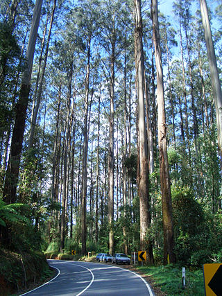
Eucalyptus regnans, known variously as mountain ash, swamp gum, or stringy gum, is a species of medium-sized to very tall forest tree that is native to the Australia states of Tasmania and Victoria. It is a straight-trunked tree with smooth grey bark, but with a stocking of rough brown bark at the base, glossy green, lance-shaped to curved adult leaves, flower buds in groups of between nine and fifteen, white flowers, and cup-shaped or conical fruit. It is the tallest of all flowering plants; the tallest measured living specimen, named Centurion, stands 100 metres tall in Tasmania.

<span class="mw-page-title-main">Cradle Mountain</span> Mountain in Tasmania

Cradle Mountain is a locality and mountain in the Central Highlands region of the Australian state of Tasmania. The mountain is situated in the Cradle Mountain-Lake St Clair National Park.

<span class="mw-page-title-main">Tasmanian temperate rainforests</span> Terrestrial ecoregion in Tasmania, Australia

The Tasmanian temperate rain forests are a temperate broadleaf and mixed forests ecoregion in western Tasmania. The ecoregion is part of the Australasian realm, which includes Tasmania and Australia, New Zealand, New Guinea, New Caledonia, and adjacent islands.

<span class="mw-page-title-main">Great Western Tiers</span> Mountain range in Tasmania, Australia

The Great Western Tiers are a collection of mountain bluffs that form the northern edge of the Central Highlands plateau in Tasmania, Australia. The bluffs are contained within the Tasmanian Wilderness World Heritage Site.

<span class="mw-page-title-main">Geography of Tasmania</span>

Tasmania, the largest island of Australia, has a landmass of 68,401 km2 (26,410 sq mi) and is located directly in the pathway of the notorious "Roaring Forties" wind that encircles the globe. To its north, it is separated from mainland Australia by Bass Strait. Tasmania is the only Australian state that is not located on the Australian mainland. About 2,500 kilometres south of Tasmania island lies the George V Coast of Antarctica. Depending on which borders of the oceans are used, the island can be said to be either surrounded by the Southern Ocean, or to have the Pacific on its east and the Indian to its west. Still other definitions of the ocean boundaries would have Tasmania with the Great Australian Bight to the west, and the Tasman Sea to the east. The southernmost point on mainland Tasmania is approximately 43°38′37″S146°49′38″E at South East Cape, and the northernmost point on mainland Tasmania is approximately 40°38′26″S144°43′33″E in Woolnorth / Temdudheker near Cape Grim / Kennaook. Tasmania lies at similar latitudes to Te Waipounamu / South Island of New Zealand, and parts of Patagonia in South America, and relative to the Northern Hemisphere, it lies at similar latitudes to Hokkaido in Japan, Northeast China (Manchuria), the north Mediterranean in Europe, and the Canada-United States border.

<span class="mw-page-title-main">Meander, Tasmania</span> Town in Tasmania, Australia

Meander is a rural locality and town in the local government area of Meander Valley in the Launceston region of Tasmania. The locality is about 34 kilometres (21 mi) south-west of the town of Westbury. The 2016 census has a population of 328 for the state suburb of Meander.

<span class="mw-page-title-main">Ben Lomond (Tasmania)</span> Mountain in the north of Tasmania

Ben Lomond is a mountain in the north-east of Tasmania, Australia.

<span class="mw-page-title-main">Styx Valley</span> Valley on the island of Tasmania, Australia

The Styx Valley is a valley located adjacent to the Tasmanian Wilderness World Heritage Area on the island of Tasmania, Australia. The Styx River is the main drainage system of the valley that lies about 100 kilometres (62 mi) northwest of Hobart, with the nearest town being Maydena.

<span class="mw-page-title-main">South Esk River</span> River in Tasmania, Australia

The South Esk River, the longest river in Tasmania, is a major perennial river located in the northern region of Tasmania, Australia.

<span class="mw-page-title-main">Mole Creek</span> Town in Tasmania, Australia

Mole Creek is a town in the upper Mersey Valley, in the central north of Tasmania, Australia. Mole Creek is well known for its honey and accounts for about 35 percent of Tasmania's honey production. The locality is in the Meander Valley Council area, but with about 3% in the Kentish Council LGA.

<span class="mw-page-title-main">Liffey Falls</span> Waterfall in Tasmania, Australia

The Liffey Falls, a series of four distinct tiered–cascade waterfalls on the Liffey River, is located in the Midlands region of Tasmania, Australia. The falls are a significant massacre site where 30–60 Aboriginal people were murdered in a reprisal killing for the killing of the stockman William Knight by Aboriginal people.

<span class="mw-page-title-main">Mount Pelion West</span> Mountain in Tasmania, Australia

Mount Pelion West is a mountain located in the Central Highlands region of Tasmania, Australia. The mountain is part of the Pelion Range and is situated within the Cradle Mountain-Lake St Clair National Park at the easternmost boundary of the Murchison River catchment.

The Liffey Valley Reserve is a nature reserve comprising four separate parcels of land, with a combined area of 275 ha, in the Liffey Valley of northern Tasmania, Australia. It lies about 55 km (34 mi) south-west of Launceston and 25 km (16 mi) south-east of Deloraine. It is owned and managed by Bush Heritage Australia (BHA).

<span class="mw-page-title-main">Mount Misery (Tasmania)</span> Mountain in Tasmania

Mount Misery is the dominant feature overlooking Huonville in southern Tasmania. With an elevation of 690 metres (2,260 ft), it is typical of most of the peaks surrounding Huonville; but its location on a bend of the Huon River makes it the dominant feature in many tourist photos.

<span class="mw-page-title-main">Dry's Bluff</span> Mountain in Tasmania, Australia

Dry's Bluff is a mountain in the Great Western Tiers Range in Tasmania. The walk to its summit is listed in The Abels as one of the hardest day walks in Tasmania with an elevation gain of over 1000m from the base of the plateau. Access to the start of the walk is through Bob Brown's residence Oura Oura which has the sign Trespassers Welcome on the gate.

<span class="mw-page-title-main">Tasmanian temperate forests</span> Ecoregion in Tasmania, Australia

The Tasmanian temperate forests is a temperate broadleaf and mixed forests ecoregion in Australia. The ecoregion occupies the eastern portion of the island of Tasmania, which lies south of the Australian mainland.

<span class="mw-page-title-main">Tasmanian Central Highland forests</span> Terrestrial ecoregion in Tasmania, Australia

The Tasmanian Central Highland forests is a temperate broadleaf and mixed forests ecoregion in Australia. It covers Tasmania's Central Highlands region.

References

  1. 1 2 3 4 Forestry Commission of Tasmania, p.9
  2. 1 2 "Quamby Bluff, Australia". Peakbagger.com. Retrieved 5 June 2017.
  3. "Place Names Search: QUAMBY BLUFF". Geoscience Australia. Retrieved 30 August 2007.
  4. 1 2 John Champman, MonicaChapman (2003), Day Walks Tasmania, John Champman
  5. Lloyd, p.5
  6. Bunce, Daniel (1859). Travels with Dr Leichhardt in Australia. p. 41. Retrieved 11 October 2017.
  7. Fish and Yaxley, pp.12,253
  8. 1 2 Lloyd, p.15
  9. 1 2 Forestry Commission of Tasmania, p.19
  10. 1 2 Forestry Commission of Tasmania, p.11
  11. Reid, p.16
  12. 1 2 Lloyd, p.11
  13. Lloyd, p.7
  14. Lloyd, p.12
  15. Plomley, N.J.B (Brian) (1991). Tasmanian Aboriginal Place Names. Launceston: QVMAG. p. 20.
  16. Breen p.1
  17. Breen, p.3
  18. "Centre for 21st Century Humanities".
  19. Lloyd, p.16
  20. 1 2 Lloyd, p.14
  21. Lloyd, p.13
  22. Lloyd, pp.1011
  23. Forestry Commission of Tasmania, p.18
  24. 1 2 Forestry Commission of Tasmania, p.20
  25. Hardinge, Alice; Beckerling, Jess (16 January 2024). "Campaigns to End Logging in Australia (Commons Conversations Podcasts)". The Commons Social Change Library. Retrieved 29 February 2024.
  26. "Forest Management Act 2013 - Schedule 3". Government of Tasmania. 2013. Retrieved 29 March 2015.
  27. "Notice of areas added to the Tasmanian Wilderness World Heritage Area in 2010, 2012 and 2013". Department for Environment. 5 August 2013. Retrieved 29 March 2015.

Notes

  1. The bluff is listed as 1,228 metres (4,029 ft) in the Quamby Bluff 1:25000 Topographic/Cadastral Map Number#4638 published by TASMAP, by 1,227 metres (4,026 ft) in other sources

Bibliography