
Highways in Australia are generally high capacity roads managed by state and territory government agencies, though Australia's federal government contributes funding for important links between capital cities and major regional centres. Prior to European settlement, the earliest needs for trade and travel were met by narrow bush tracks, used by tribes of Indigenous Australians. The formal construction of roads began in 1788, after the founding of the colony of New South Wales, and a network of three major roads across the colony emerged by the 1820s. Similar road networks were established in the other colonies of Australia. Road construction programs in the early 19th century were generally underfunded, as they were dependent on government budgets, loans, and tolls; while there was a huge increase in road usage, due to the Australian gold rushes. Local government authorities, often known as Road Boards, were therefore established to be primarily responsible for funding and undertaking road construction and maintenance. The early 1900s saw both the increasingly widespread use of motorised transportation, and the creation of state road authorities in each state, between 1913 and 1926. These authorities managed each state's road network, with the main arterial roads controlled and maintained by the state, and other roads remaining the responsibility of local governments. The federal government became involved in road funding in the 1920s, distributing funding to the states. The depression of the 1930s slowed the funding and development of the major road network until the onset on World War II. Supply roads leading to the north of the country were considered vital, resulting in the construction of Barkly, Stuart, and Eyre Highways.
New England Highway is an 883-kilometre (549 mi) long highway in Australia running from Yarraman, north of Toowoomba, Queensland at its northern end to Hexham at Newcastle, New South Wales at its southern end. It is part of Australia's National Highway system, and forms part of the inland route between Brisbane and Sydney.

Great Western Highway is a 202-kilometre-long (126 mi) state highway in New South Wales, Australia. From east to west, the highway links Sydney with Bathurst, on the state's Central Tablelands.
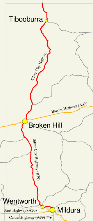
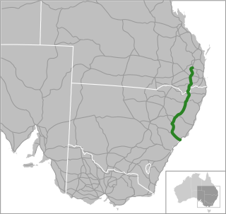
Silver City Highway is a 683-kilometre-long (424 mi) highway that links Buronga, New South Wales to the Queensland border via Wentworth, Broken Hill, and Tibooburra, in the arid Far West region of New South Wales; a short branch also connects to Calder Highway on the Victorian border at Curlwaa. Parts of the highway north of Tibooburra are unsealed. The namesake of the highway is derived from the moniker for Broken Hill - the "Silver City" - which the highway travels through. The highway is designated route B79 from Broken Hill to Buronga.
The Bass Highway is a highway in Tasmania, Australia. It connects the three cities across the north of the state – Burnie, Devonport and Launceston. The road was named due to its proximity to the Bass Strait. It is a part of the National Highway, designated as National Highway 1, together with the Midland and Brooker highways in Tasmania.

The Tasman Highway is a highway in Tasmania, Australia. Like the Midland Highway, it connects the major cities of Hobart and Launceston – however it takes a different route, via the north-eastern and eastern coasts of the state. The Highway also acts as a major commuter road to Hobart residents living on the eastern side of the Derwent River. The designation "Tasman Highway" arises from its location facing the Tasman Sea – named, like the state itself, after Abel Tasman. The highway is one of the longest in Tasmania - 410 km (250 mi), with an average traveling time of 41⁄2 hours.
The Great Lake, officially yingina / Great Lake, is a natural lake and man-made reservoir that is located in the central northern region of Tasmania, Australia.
A routenumber, designation or abbreviation is an identifying numeric designation assigned by a highway authority to a particular stretch of roadway to distinguish it from other routes and, in many cases, also to indicate its classification, general geographical location and/or orientation. The numbers chosen may be used solely for internal administrative purposes; however, in most cases they are also displayed on roadside signage and indicated on maps.

Waddamana Hydro-Electric power station was the first hydro-electric power plant ever operated by the Tasmanian Hydro-Electric Department, opened in 1916.

The Lyell Highway is a highway in Tasmania, running from Hobart to Queenstown. It is the one of two transport routes that passes through the West Coast Range, the other being the Anthony Road.

Central Plateau Conservation Area is an animal and plant conservation area in Tasmania, Australia. It is adjacent to the Walls of Jerusalem National Park.

The Central Highlands is a region in Tasmania, Australia where geographical and administrative boundaries closely coincide. It is also known as The Lake Country of Tasmania.
Main Road is a major arterial road that runs through the northern suburbs of Hobart, Tasmania. The road continues on from New Town Road at Lenah Valley and runs in close proximity with the Southern Railway Line and travels on a near parallel trajectory with the Derwent River until it reaches Granton where it merges with the Brooker Highway. Prior to the construction of the Brooker Highway the only way traffic could travel to the northern cities of the state was to drive via Main Road.
The Poatina Power Station is a conventional hydroelectric power station located in the Central Highlands region of Tasmania, Australia. The power station is situated on the Great Lake and South Esk and is owned and operated by Hydro Tasmania.
The Arthurs Lake is a man-made reservoir located in the Central Highlands region of Tasmania, Australia. The lake was created in the 1920s by the Hydro-Electric Commission of Tasmania damming the Upper Lake River, Blue Lake and Sand Lake as well as the Morass Marsh. The principal purpose of the lake is to support the generation of hydroelectricity.

In Tasmania, Highway 1 is a 336-kilometre (209 mi) long route that connects Hobart to the state's north coast, and to Launceston via a 3.8-kilometre (2.4 mi) long spur. Highway 1 also exists on the mainland of Australia, linking the state capitals via a circular route around the coastline. All roads within the Highway 1 system are allocated a road route numbered 1, M1, A1, or B1, depending on the state route numbering system. In Tasmania the highway is designated as National Highway 1, though all other routes in the state are alphanumeric.

Highways and main roads in the Wheatbelt region of Western Australia form the basis of a road network, which is primarily used by the mining, agriculture, and tourism industries. Main Roads Western Australia maintains and controls these major roads, with offices based in Northam and Narrogin.
Main Roads Western Australia controls the major roads in the state's Kimberley region. Great Northern Highway is the major road connection through the region, with sealed roads spurring off it to connect to population centres, and unsealed roads offering an alternative route between Derby and Wyndham.
Steppes is a rural locality in the local government area of Central Highlands in the Central region of Tasmania. It is located about 80 kilometres (50 mi) north of the town of Hamilton. The 2016 census determined a population of nil for the state suburb of Steppes.