Councils of Tasmania are the 29 administrative districts of the Australian state of Tasmania. Local government areas (LGAs), more generally known as councils, are the tier of government responsible for the management of local duties such as road maintenance, town planning and waste management.

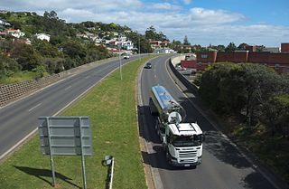
The Midland Highway is one of Tasmania's major inter-city highways, running for 176 kilometres (109 mi) between Hobart and Launceston. It is part of the AusLink National Network and is a vital link for road freight to transport goods to and from the two cities. It represents a major north–south transportation corridor in Tasmania and has the route 1 designation as part of the National Highway. The highway consists of various traffic lane arrangements, the most common being two lanes – one in each direction, with overtaking options and at-grade intersections. At both the Launceston and Hobart sections of the highway there are small portions of grade-separated dual carriageway.
West Tamar Council is a local government body in Tasmania, situated along the western side of the Tamar River in the north of the state. West Tamar is classified as an urban local government area and has a population of 23,769, it extends from the outer reaches of north-west Launceston and includes the towns and localities of Beaconsfield, Beauty Point and Legana.
The Bass Highway is a highway in Tasmania, Australia. It connects the three cities across the north of the state – Burnie, Devonport and Launceston. The road was named due to its proximity to the Bass Strait. It is a part of the National Highway, designated as National Highway 1, together with the Midland and Brooker highways in Tasmania.

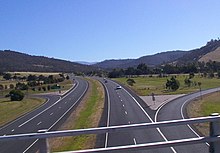
The Brooker Highway is a highway in the Australian state of Tasmania. As one of Hobart's three major radials, the highway connects traffic from the city centre with the northern suburbs and is the major road connection to the cities and towns of northern Tasmania. With an annual average daily traffic of 48,000, the highway is one of the busiest in Tasmania. The Brooker Highway has recently been declared part of the National Highway.

The Tasman Highway is a highway in Tasmania, Australia. Like the Midland Highway, it connects the major cities of Hobart and Launceston – however it takes a different route, via the north-eastern and eastern coasts of the state. The Highway also acts as a major commuter road to Hobart residents living on the eastern side of the Derwent River. The designation "Tasman Highway" arises from its location facing the Tasman Sea – named, like the state itself, after Abel Tasman. The highway is one of the longest in Tasmania – 410 km (250 mi), with an average travelling time of 41⁄2 hours.

The Southern Football League is an Australian rules football league based in Tasmania, Australia.

The Tasmanian Government Railways (TGR) was the former operator of the mainline railways in Tasmania, Australia. Formed in 1872, the railway company was managed by the Government of Tasmania, and existed until absorption into the Australian National Railways Commission in 1978.

Rail transport in Tasmania consists of a network of narrow gauge track of 1,067 mm reaching virtually all cities and major towns in the island state of Tasmania, Australia. Today, rail services are focused primarily on bulk freight, with no commercial passenger services being operated. The mainline railways of Tasmania are currently operated by TasRail, a Government of Tasmania-owned Corporation, who owns and maintains both rolling stock, locomotives, and track infrastructure.

Metro Tasmania, commonly called Metro, a Tasmanian Government business enterprise, is the largest bus operator in the state of Tasmania, Australia, with operations in three of the four largest urban centres of Hobart, Launceston, and Burnie. Urban services in Devonport are provided by a private operator, Kinetic. Services are provided by Metro under a range of urban and non-urban contracts with the Transport Commission, a division within the Department of State Growth.

The West Tamar Highway is a highway in Tasmania, Australia. It covers the western edge of the Tamar River, from Launceston to the beach town of Greens Beach.
The East Tamar Highway is a highway in Tasmania, Australia. It covers the eastern edge of the Tamar River, from Launceston to the lighthouse at Low Head.

Triabunna is a rural residential locality in the local government area (LGA) of Glamorgan–Spring Bay in the South-east LGA region of Tasmania. The locality is about 86 kilometres (53 mi) north-east of the city of Hobart. The 2021 census has a population of 905 for the state suburb of Triabunna.
The Channel Highway is a regional highway that travels south from Hobart To Huonville, Tasmania, Australia. The Channel Highway starts from the end of Sandy Bay Road and travels south toward Huonville via Taroona, Kingston, Huntingfield, Margate, Kettering, Woodbridge and Cygnet. The shortest way from Hobart to Huonville is via the Huon Highway. Prior to the construction of the Southern Outlet the Channel Highway was the main route used to get to Kingston and other southern towns.
Grove is a rural locality in the local government area (LGA) of Huon Valley in the South-east region of Tasmania, Australia. The locality is 35 km southwest of Hobart and 7 km north-east of the town of Huonville. As a rural locality, there are no urban settlements in Grove. The 2016 census does not provide a population for the locality of Grove. It covers an area of approximately 30.8 km². The postcode for Grove is 7109.
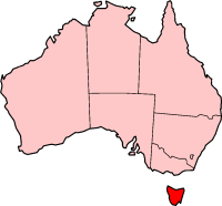
In the Australian state of Tasmania, there are many areas which are commonly known by regional names. Regions are areas that share similar characteristics. These characteristics may be natural such as the Furneaux Islands, the coastline, or the Central Highlands. Alternatively, the characteristics may be cultural, such as a viticulture land use. Tasmania is divided by numerous regional boundaries, based on different characteristics. In many cases boundaries defined by different government agencies are coterminous and are often cited by the Australian and local media that tend to distinguish between North West, West Coast, Southern, and East Coast.
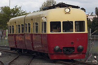
The Tasman Limited was a passenger train operated by Tasmanian Government Railways (TGR) on the Main and Western lines between Hobart, Launceston and Wynyard from April 1954 to July 1978.

 Brooker Highway