Lyell Highway

Last updated


Lyell Highway

West Coast Road descending to Queenstown.jpg
Lyell Highway descending towards Queenstown
Lyell Highway
General information
TypeHighway
Length248 km (154 mi)
Route number(s) AUS Alphanumeric Route A10.svg A10
GrantonQueenstown
AUS Alphanumeric Route B24.svg B24
QueenstownStrahan
Former
route number
Australian state route 8.svg State Route 8
Major junctions
SSE endAustralian national highway 1.svg Brooker Highway
Granton, Hobart, Tasmania
 
NNW endAUS Alphanumeric Route B27.svg Esplanade
Strahan, Tasmania
Location(s)
Major settlements New Norfolk, Ouse, Queenstown
Highway system

The Lyell Highway (Route A10) is a highway in Tasmania, running from Hobart to Queenstown. It is the one of two transport routes that passes through the West Coast Range, the other being the AUS Alphanumeric Route B28.svg Anthony Road.

Contents

Name

The name is derived from Mount Lyell, the mountain peak where copper was found in the late 19th century; the Mount Lyell Mining and Railway Company was the predominant business in Queenstown for almost 100 years.

Hobart to Central Highlands section

Starting at Granton it winds along the southern side of the Derwent River in a generally north westerly direction to New Norfolk. This section has in the past been susceptible to flooding. [1] [2]

At New Norfolk it crosses the Derwent River and winds its way through hilly terrain to Hamilton. Just prior to Hamilton is the turnoff to Bothwell via a sealed route that passes Arthurs Lake and ultimately goes on to Launceston.

Central Highlands section

After Hamilton, the small town of Ouse is the only other population centre on the highway until the former Hydroelectricity town of Wayatinah.

When the highway was first constructed, it made use of existing tracks and roads in the Victoria Valley area, directly north of Ouse, leaving the Ouse and Derwent River valleys and climbing the hilly country through the towns of Osterley, Victoria Valley and Dee before rejoining the present highway near Brontë. This route closely skirts Dee Lagoon, and runs close to several other lakes, particularly Lake Echo. The now-bypassed road is narrow, and unsealed.

When the hydro-electric system was expanding and their works were under construction at Tarraleah, the highway was re-aligned to follow the Derwent River until it passed Tarraleah to provide better access to the area for construction vehicles. The Ouse–Tarraleah section was opened to traffic in August 1940 even though construction work had not finished. After Tarraleah the road climbs steeply out of the Nive River gorge until it re-joins the original route near Brontë.

At Brontë the Marlborough Highway (B11) turns off the main road and leads to the Great Lake, where it joins the Lakes Highway and eventually runs to Deloraine.

A common short-cut is the "14-Mile Road" (C601), a gravel road which cuts across the Nive Plains just after Tarraleah, by-passing the steep Tarraleah Gorge section, re-joining the highway several kilometres past Brontë. It is not a safe alternative as it is a narrow, unsealed road, and can be frequented by log-trucks. In wintry conditions the whole of the Central Highlands section is susceptible to black ice, and it can be exceptionally bad in the heavily forested section west of Ouse, but it can be encountered all the way to the west coast. Snow is usually encountered in the Derwent Bridge area during most winters and may force closure of the road occasionally for several days. [3] This applies to both the newer Tarraleah section and the older Osterley–Lake Echo–Dee section.

As the highway enters Derwent Bridge it strikes a midpoint between Lake St Clair to the north, and Lake King William to the south.

West Coast section

This section is usually known as that west of Derwent Bridge or Mount King William. [4]

It runs through the Franklin-Gordon Wild Rivers National Park, and through the West Coast Range before reaching Queenstown. There has also been a state reserve along the highway. [5]

The highway did not reach Queenstown until November 1932, [6] and was not properly surfaced for some time after that, and frequently blocked. [7] [8]

During construction in the late 1920s and early 1930s it was called the West Coast Road. [9] [10]

Due to its altitude, the section of the highway over the plateau between Derwent Bridge and Mount King William is often closed during winter due to ice and snow. [11] It can also be affected by rockfalls. [12]

With the damming of the King River and the creation of Lake Burbury, the highway was re-routed to a narrow point where the Bradshaw bridge could be constructed across the lake.

See also

Notes

  1. "Lyell Highway Flooding". The Mercury . Hobart, Tasmania. 8 August 1947. p. 8. Retrieved 12 October 2012 via National Library of Australia.
  2. Tasmania. Dept. of Infrastructure, Energy & Resources (2008), Lyell Highway, Granton to New Norfolk, Department of Infrastructure, Energy & Resources, retrieved 12 October 2012
  3. "SNOW BENDS POLES ON LYELL HIGHWAY". The Mercury . Hobart, Tasmania. 26 August 1946. p. 2. Retrieved 12 October 2012 via National Library of Australia.
  4. Tasmania. Land Information Bureau; Tasmania. Parks and Wildlife Service (1994), Lyell Highway map and notes between Derwent Bridge and Strahan, Tasmanian Wilderness World Heritage Area, Parks and Wildlife Service Tasmania, retrieved 12 October 2012
  5. Tasmania. Parliament (1979), Management plan for the Lyell Highway State Reserve, April 1979, Govt. Pr, ISBN   978-0-7246-0934-5
  6. Opening day being the 19th of November 1932 - p.5 of Rae, Lou (1999), The Abt Railway and railways of the Lyell Region, L. Rae, ISBN   978-0-9592098-7-7
  7. "Lyell Highway Open". The Examiner (Tasmania) . Vol. C, no. 144. Tasmania, Australia. 27 August 1941. p. 4 (LATE NEWS EDITION). Retrieved 19 November 2018 via National Library of Australia.
  8. "Topics of The Day Lyell Highway Not Yet Open". The Examiner (Tasmania) . Vol. CII, no. 135. Tasmania, Australia. 17 August 1943. p. 4. Retrieved 19 November 2018 via National Library of Australia.
  9. "THE WEST COAST ROAD". The Mercury . Vol. CXXX, no. 19, 151. Tasmania, Australia. 25 March 1929. p. 6. Retrieved 19 November 2018 via National Library of Australia.
  10. "THE WEST COAST ROAD". The Mercury . Vol. CXXXIV, no. 19, 836. Tasmania, Australia. 5 March 1931. p. 6. Retrieved 19 November 2018 via National Library of Australia.
  11. "LYELL HIGHWAY". The Mercury . Hobart, Tasmania. 27 August 1941. p. 6. Retrieved 12 October 2012 via National Library of Australia.
  12. "Landslide Blocks Lyell Highway". The Mercury . Hobart, Tasmania. 22 September 1950. p. 8. Retrieved 12 October 2012 via National Library of Australia.

Related Research Articles

Councils of Tasmania are the 29 administrative districts of the Australian state of Tasmania. Local government areas (LGAs), more generally known as councils, are the tier of government responsible for the management of local duties such as road maintenance, town planning and waste management.

<span class="mw-page-title-main">Central Highlands Council</span> Local government area in Tasmania, Australia

Central Highlands Council is a local government body in Tasmania, encompassing the Central Highlands region of the state. Central Highlands is classified as a rural local government area and has a population of 2,144, the two largest towns are Bothwell and Hamilton.

<span class="mw-page-title-main">Bridgewater Bridge (Tasmania)</span> Road and rail bridge in Tasmania, Australia

The Bridgewater Bridge is a combined road and rail bridge that carries the Midland Highway and South Railway Line across the Derwent River in Hobart, Tasmania, Australia. This steel truss vertical lift bridge and specially-built causeway connect the Hobart suburbs of Bridgewater and Granton. The bridge was completed in 1946 and accommodates a two-lane highway, a single track railway and a grade-separated footpath.

Trial Harbour is a rural locality in the local government area (LGA) of West Coast in the North-west and west LGA region of Tasmania. The locality is about 20 kilometres (12 mi) south-west of the town of Zeehan. The 2016 census has a population of 24 for the state suburb of Trial Harbour.

Gormanston is a town in Tasmania on the slopes of Mount Owen, above the town of Queenstown in Tasmania's West Coast. In the 2016 census, Gormanston had a population of 17.

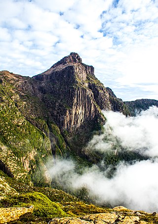
Mount Read is a mountain located in the West Coast region of Tasmania, Australia, and is at the north west edge of the West Coast Range.

<span class="mw-page-title-main">North Mount Lyell Railway</span> Former railway company in Tasmania, Australia

The North Mount Lyell Railway was built to operate between the North Mount Lyell mine in West Coast Tasmania and Pillinger in the Kelly Basin of Macquarie Harbour.

<span class="mw-page-title-main">Mount Owen (Tasmania)</span> Mountain in Tasmania, Australia

Mount Owen is a mountain directly east of the town of Queenstown on the West Coast Range in Western Tasmania, Australia.

<span class="mw-page-title-main">Mount Huxley (Tasmania)</span> Mountain in Western Tasmania, Australia

Mount Huxley is a mountain located on the West Coast Range in the West Coast region of Tasmania, Australia. With an elevation of 926 metres (3,038 ft) above sea level, the mountain was named by Charles Gould in 1863 in honour of Professor Thomas Henry Huxley.

The Strahan–Zeehan Railway, also known as the "Government Railway", was a railway from Strahan to Zeehan on the west coast of Tasmania.

Thomas Bather Moore was a pioneer explorer of Western and South West, Tasmania, Australia.

<span class="mw-page-title-main">Granton, Tasmania</span> Suburb of City of Glenorchy, Tasmania, Australia

Granton is a rural residential locality in the local government areas (LGA) of Derwent Valley (80%) and Glenorchy (20%) in the South-east and Hobart LGA regions of Tasmania. The locality is about 9 kilometres (5.6 mi) north of the town of Glenorchy. The 2016 census recorded a population of 1736 for the state suburb of Granton. It is a suburb of Hobart. Rust Road is the approximate boundary between the two municipalities at Granton.

<span class="mw-page-title-main">South West Tasmania</span> Region in Tasmania, Australia

South West Tasmania is a region in Tasmania that has evoked curiosity as to its resources over the duration of European presence on the island.

Tarraleah is a rural locality in the local government area (LGA) of Central Highlands in the Central LGA region of Tasmania. The locality is about 53 kilometres (33 mi) north-west of the town of Hamilton. The 2016 census has a population of nil for the state suburb of Tarraleah.

<span class="mw-page-title-main">West Coast Wilderness Railway</span> Rebuilt railway between Queenstown and Strahan, Western Tasmania, Australia

The West Coast Wilderness Railway is a reconstruction of the Mount Lyell Mining and Railway Company Mount Lyell railway in Western Tasmania between Queenstown and Regatta Point, Strahan. The railway is significant because of its Abt rack system to conquer the mountainous terrain through rainforest, with original locomotives still operating on the railway today. Now operating as a tourist experience with a focus on sharing the history of Tasmania's West Coast, the original railway began operations in 1897 as the only link between Queenstown and the port of Strahan.

In June 1947 the southern half of Tasmania was affected by its largest floods on record. Although flooding at its peak between 16 and 18 June affected almost all rivers and streams across the island, in the rest of the state, the flooding did not approach the extent of the better-known 1929 floods. Floods on rivers such as the Derwent and Huon were the largest on record and caused considerable damage.

<span class="mw-page-title-main">Highway 1 (Tasmania)</span>

In Tasmania, Highway 1 is a 336-kilometre (209 mi) long route that connects Hobart to the state's north coast, and to Launceston via a 3.8-kilometre (2.4 mi) long spur. Highway 1 also exists on the mainland of Australia, linking the state capitals via a circular route around the coastline. All roads within the Highway 1 system are allocated a road route numbered 1, M1, A1, or B1, depending on the state route numbering system. In Tasmania the highway is designated as National Highway 1, though all other routes in the state are alphanumeric.

Zeehan Highway is a road between Zeehan and Queenstown in Western Tasmania.

References