Mount Jukes (Tasmania)

Last updated

Mount Jukes
Northside of Jukes.jpg
Aerial photograph of lower slopes of Mount Huxley (to the left), King River gorge in the left lower, Crotty Dam and Lake Burbury (to the rear), northern slopes (that is Proprietary Peak) of Mount Jukes on the right, Mount Jukes Road in right foreground, and to the right rear the different coloured upper part of East Jukes Peak.
Highest point
Elevation 1,168 m (3,832 ft) [1]
Prominence 911 m (2,989 ft) [1]
Isolation 23.09 km (14.35 mi) [1]
Coordinates 42°10′12″S145°34′48″E / 42.17000°S 145.58000°E / -42.17000; 145.58000 Coordinates: 42°10′12″S145°34′48″E / 42.17000°S 145.58000°E / -42.17000; 145.58000 [2]
Geography
Relief Map of Tasmania.png
Red triangle with thick white border.svg
Mount Jukes
Location in Tasmania
Location West Coast, Tasmania, Australia
Parent range Jukes Range, West Coast Range
Topo map
  • Owen 3833
  • Darwin 3832
Geology
Age of rock Jurassic

Mount Jukes is a mountain located on the Jukes Range, a spur off the West Coast Range, in the West Coast region of Tasmania, Australia. [3]

Contents

With an elevation of 1,168 metres (3,832 ft) above sea level, [1] with multiple peaks, and glacial lakes on its upper eastern reaches, Mount Jukes is situated above the town of Crotty and is west of Lake Burbury.

The mountain was named by Charles Gould in 1862 in honour of Professor Joseph Jukes, an English geologist who gathered evidence to part afforded support for Charles Darwin's theories of coral reefs. Jukes had visited Hobart in 1842-3 on HMS Fly. [3]

Mines

It has had mines and small mining camps adjacent to the lakes, and on the northern upper slopes, near where the Mount Jukes road traverses the upper slopes of the King River Gorge. These mines provide resources to nearby areas and give power to the surrounding areas.

Aerial view of north east corner of Mount Jukes from the east, with Lake Burbury in view, and Crotty Dam at the right Mount Jukes and burbury.JPG
Aerial view of north east corner of Mount Jukes from the east, with Lake Burbury in view, and Crotty Dam at the right

Access and features

The Mount Jukes Road (22 kilometres (14 mi) in length) [4] was constructed by the Hydro in the 1980s at the time the Crotty Dam was made. It connects southern Queenstown with Darwin Dam, where the previously utilised North Mount Lyell Railway formation between the Linda Valley and Crotty was submerged by Lake Burbury.

Two named glacial lakes in the upper part of the eastern side of the mountain are the Upper Lake Jukes and the Lower Lake Jukes. It is by the lakes that a number of small mines were started in the early years of the twentieth century.

Mount Huxley is located to the north and Mount Darwin is located to the south.

Peaks and spurs

Mount Jukes has a number of named features: [5] [6] [7]

Some other named features include Yellow Knob, Yellow Knob Spur, South Jukes Spur, Crown Spur, East Jukes Spur, Intercolonial Spur, Cliff Spur, and Newall Spur.

Mount Jukes from the north west Mount Jukes from West.jpg
Mount Jukes from the north west

See also

Related Research Articles

<span class="mw-page-title-main">King River (Tasmania)</span> River in Tasmania, Australia

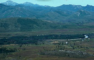
The King River is a major perennial river in the West Coast region of Tasmania, Australia.

<span class="mw-page-title-main">West Coast Range</span> Mountain range in Tasmania, Australia

The West Coast Range is a mountain range located in the West Coast region of Tasmania, Australia.

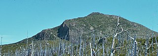
Mount Lyell is a mountain in the West Coast Range of Western Tasmania, Australia.

Crotty is a former gazetted townsite that was located in Western Tasmania, Australia. The township was located on the eastern lower slopes of Mount Jukes, below the West Coast Range, and on the southern bank of the King River. The locality had had a former name of King River

<span class="mw-page-title-main">North Mount Lyell Railway</span> Former railway company in Tasmania, Australia

The North Mount Lyell Railway was built to operate between the North Mount Lyell mine in West Coast Tasmania and Pillinger in the Kelly Basin of Macquarie Harbour.

<span class="mw-page-title-main">Mount Owen (Tasmania)</span> Mountain in Tasmania, Australia

Mount Owen is a mountain directly east of the town of Queenstown on the West Coast Range in Western Tasmania, Australia.

The Mount Jukes mine sites were a series of short-lived, small mine workings high on the upper regions of Mount Jukes in the West Coast Range on the West Coast of Tasmania.

<span class="mw-page-title-main">Lake Burbury</span> Lake in Tasmania, Australia

Lake Burbury is a man-made water reservoir created by the Crotty Dam inundating the upper King River valley that lies east of the West Coast Range. Discharge from the reservoir feeds the John Butters Hydroelectric Power Station, owned and operated by Hydro Tasmania.

<span class="mw-page-title-main">Mount Huxley (Tasmania)</span> Mountain in Western Tasmania, Australia

Mount Huxley is a mountain located on the West Coast Range in the West Coast region of Tasmania, Australia. With an elevation of 926 metres (3,038 ft) above sea level, the mountain was named by Charles Gould in 1863 in honour of Professor Thomas Henry Huxley.

Mount Darwin is a mountain located in the West Coast region of Tasmania, Australia.

<span class="mw-page-title-main">Crotty Dam</span> Dam in Western Tasmania, Australia

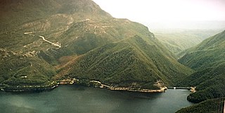
The Crotty Dam, also known during construction as the King Dam, or the King River Dam on initial approval, is a rockfill embankment dam with a controlled and uncontrolled spillway across the King River, between Mount Jukes and Mount Huxley, located in Western Tasmania, Australia.

<span class="mw-page-title-main">Mount Sedgwick (Tasmania)</span> Mountain in Tasmania, Australia

Mount Sedgwick is a mountain located within the West Coast Range, in the West Coast region of Tasmania, Australia.

<span class="mw-page-title-main">Darwin Dam</span> Dam in Tasmania, Australia

The Darwin Dam is an offstream earthfill embankment saddle dam without a spillway, located in Western Tasmania, Australia. The impounded reservoir, also formed by Crotty Dam, is called Lake Burbury.

Mount Geikie is a mountain in the West Coast Range of Western Tasmania, Australia.

The Sticht Range is a mountain range located in the West Coast region of Tasmania, Australia. The range runs between two tributaries of the Eldon River and is located within the eastern part of the West Coast Range and has an unnamed peak with an elevation of 1,080 metres (3,540 ft) above sea level.

<span class="mw-page-title-main">Lake Beatrice</span> Lake in West Coast Range, Tasmania, Australia

Lake Beatrice is a 55-hectare (140-acre) natural lake on the lower eastern side of Mount Sedgwick in the West Coast Range of Western Tasmania, Australia.

<span class="mw-page-title-main">Tyndall Range</span> Mountains in Western Tasmania, Australia

The Tyndall Range, commonly called The Tyndalls, is a mountain range that is part of the West Coast Range located in the Western region of Tasmania, Australia.

The John Butters Power Station is a conventional hydroelectric power station located in Western Tasmania, Australia. The power station forms part of the King – Yolande River Power Scheme and is owned and operated by Hydro Tasmania.

References

  1. 1 2 3 4 5 "Mount Jukes, Australia". Peakbagger.com. Retrieved 17 June 2015.
  2. "Mount Jukes (TAS)". Gazetteer of Australia online. Geoscience Australia, Australian Government.
  3. 1 2 Baillie, Peter (2010). "The West Coast Range, Tasmania: Mountains and Geological Giants" (PDF). Papers and Proceedings of the Royal Society of Tasmania (reprint ed.). Hobart, Tasmania: University of Tasmania. 144: 1–13. ISSN   0080-4703. Archived from the original (PDF) on 16 June 2015. Retrieved 18 June 2015.
  4. HEC (no date) King River Power Development p.12 Construction Highlights
  5. Franklin (Map) (6 ed.). 1:100,000. Tasmap. 1997. Sheet 8013.
  6. Darwin (Map) (2 ed.). 1:25,000. Tasmap. 1999. Sheet 3832.
  7. Owen (Map) (2 ed.). 1:25,000. Tasmap. 2001. Sheet 3833.
  8. "Jukes Range (TAS)". Gazetteer of Australia online. Geoscience Australia, Australian Government.
  9. "Proprietary Peak (TAS)". Gazetteer of Australia online. Geoscience Australia, Australian Government.
  10. "Pyramid Peak (TAS)". Gazetteer of Australia online. Geoscience Australia, Australian Government.
  11. "West Jukes Peak (TAS)". Gazetteer of Australia online. Geoscience Australia, Australian Government.
  12. "South Jukes Peak (TAS)". Gazetteer of Australia online. Geoscience Australia, Australian Government.
  13. "East Jukes Peak (TAS)". Gazetteer of Australia online. Geoscience Australia, Australian Government.
  14. "Central Peak (TAS)". Gazetteer of Australia online. Geoscience Australia, Australian Government.

Further reading