Rosebery is a town on the west coast of Tasmania, Australia. It is at the northern end of the West Coast Range, in the shadow of Mount Black and adjacent to the Pieman River, now Lake Pieman.
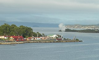
Regatta Point is the location of a port and rail terminus on Macquarie Harbour.

The Melba Line is a 1,067 mm narrow-gauge railway on the West Coast of Tasmania. The line was originally constructed as a private railway line named the Emu Bay Railway and was one of the longest-lasting and most successful private railway companies in Australia. While at present the line travels from Burnie to Melba Flats, it previously ran through to Zeehan carrying minerals and passengers as an essential service for the West Coast community.
Gormanston is a town in Tasmania on the slopes of Mount Owen, above the town of Queenstown in Tasmania's West Coast. In the 2016 census, Gormanston had a population of 17.

The North East Dundas Tramway was a 2 ft narrow gauge tramway, that ran between Zeehan and Deep Lead on the West Coast of Tasmania. Opening in 1896 and closing in 1932, it was part of the Tasmanian Government Railways network. The world's first Garratt locomotives, the K class, were used on the line.
Mount Read is a mountain located in the West Coast region of Tasmania, Australia, and is at the north west edge of the West Coast Range.

The Queen River, part of the King River catchment, is a minor perennial river located in the West Coast region of Tasmania, Australia. It is notable for its high level of pollution caused by mining runoff which has led the river to be uninhabitable to life.

The Lake Margaret Tram was located on the western side of Mount Sedgwick in the West Coast Range on the West Coast of Tasmania in service for the Mount Lyell Mining and Railway Company to the Lake Margaret community.

Lake Burbury is a man-made water reservoir created by the Crotty Dam inundating the upper King River valley that lies east of the West Coast Range. Discharge from the reservoir feeds the John Butters Hydroelectric Power Station, owned and operated by Hydro Tasmania.
Pillinger is an abandoned port and townsite in Kelly Basin, on the south eastern side of Macquarie Harbour on the West Coast of Tasmania.

Kelly Basin is a bay on the south eastern side of Macquarie Harbour on the West Coast of Tasmania. It was named after James Kelly an early explorer of the Tasmanian coastline. It was the location of the terminus of the North Mount Lyell Railway and the town of Pillinger.
Darwin was a surveyed and short-lived community at the eastern side of Mount Darwin on the West Coast Range.
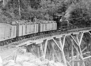
The history of the railways on the West Coast of Tasmania has fascinated enthusiasts from around the world, because of the combination of the harsh terrain in which the railways were created, and the unique nature of most of the lines.

The Wee Georgie Wood Railway is a 2 ft narrow gauge tourist tramway running from Tullah, on a 1.9 km short track by the edge of Lake Rosebery in the West Coast Municipality of Tasmania.
The Mount Dundas – Zeehan Railway was a railway line running 7 miles (11 km) from Dundas to Zeehan on the West Coast of Tasmania. It operated from 1892 until 1932, and the rails were removed in 1940.
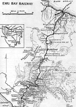
The Emu Bay Railway was a Tasmania, Australian railway company. The railway was significant during full operation, in that it linked the Tasmanian Government Railways system at Burnie with that at Zeehan that further linked to the Mount Lyell railway allowing connection through to Queenstown.

Williamsford, Tasmania is the location of a former mining community, south of Rosebery, Tasmania and on the western lower reaches of Mount Read.

The West Coast Wilderness Railway is a reconstruction of the Mount Lyell Mining and Railway Company Mount Lyell railway in Western Tasmania between Queenstown and Regatta Point, Strahan. The railway is significant because of its Abt rack system to conquer the mountainous terrain through rainforest, with original locomotives still operating on the railway today. Now operating as a tourist experience with a focus on sharing the history of Tasmania's West Coast, the original railway began operations in 1897 as the only link between Queenstown and the port of Strahan.

The Hercules Haulage, also known as the Mount Read Haulage, the Hercules Tram and the Williamsford Haulage Line, was a self-acting 2 ft narrow gauge tramway on the side of Mount Read in Western Tasmania, that connected the Hercules Mine with Williamsford and then to the North East Dundas Tramway.
The Sandfly Colliery Tramway was a 20 km (12 mi), 2 ft narrow gauge tramway linking the Kaoota Mine to Margate, Tasmania. Constructed in 1905–06, the Tramway climbed 457 m (1,499 ft) above sea level and crossed ten bridges. After coal mining ceased the tramway was used to transport logs, fruit and passengers. The line was lifted and abandoned in 1922 after bushfires destroyed several bridges along the line. Currently, 6 km (3.7 mi) of the old track is used as cycling/walking tracks, while the remainder of the old line is on private property.