Related Research Articles
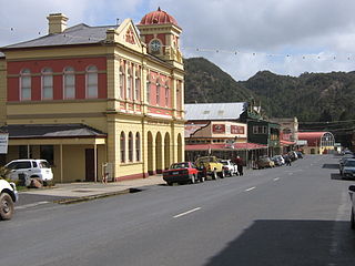
Queenstown is a town in the West Coast region of the island of Tasmania, Australia. It is in a valley on the western slopes of Mount Owen on the West Coast Range.

Macquarie Harbour is a shallow fjord in the West Coast region of Tasmania, Australia. It is approximately 315 square kilometres (122 sq mi), and has an average depth of 15 metres (49 ft), with deeper places up to 50 metres (160 ft). It is navigable by shallow-draft vessels. The main channel is kept clear by the presence of a rock wall on the outside of the channel's curve. This man-made wall prevents erosion and keeps the channel deep and narrow, rather than allowing the channel to become wide and shallow. A reported Aboriginal name for the harbour is Parralaongatek.
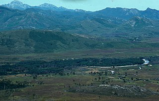
The King River is a major perennial river in the West Coast region of Tasmania, Australia.

The West Coast Range is a mountain range located in the West Coast region of Tasmania, Australia.
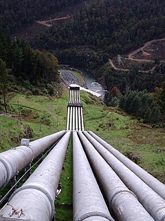
Lake Margaret is a concrete-faced gravity dam with an uncontrolled spillway across the Yolande River, located on the north side of Mount Sedgwick, in the West Coast Range, West Coast of Tasmania, Australia.
Mount Lyell Mining and Railway Company was a Tasmanian mining company formed on 29 March 1893, most commonly referred to as Mount Lyell. Mount Lyell was the dominant copper mining company of the West Coast from 1893 to 1994, and was based in Queenstown, Tasmania.
Mount Read is a mountain located in the West Coast region of Tasmania, Australia, and is at the north west edge of the West Coast Range.
Crotty is a former gazetted townsite that was located in Western Tasmania, Australia. The township was located on the eastern lower slopes of Mount Jukes, below the West Coast Range, and on the southern bank of the King River. The locality had had a former name of King River

The North Mount Lyell Railway was built to operate between the North Mount Lyell mine in West Coast Tasmania and Pillinger in the Kelly Basin of Macquarie Harbour.

The Queen River, part of the King River catchment, is a minor perennial river located in the West Coast region of Tasmania, Australia.

Lake Burbury is a man-made water reservoir created by the Crotty Dam inundating the upper King River valley that lies east of the West Coast Range. Discharge from the reservoir feeds the John Butters Hydroelectric Power Station, owned and operated by Hydro Tasmania.
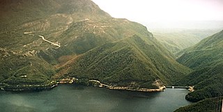
The Crotty Dam, also known during construction as the King Dam, or the King River Dam on initial approval, is a rockfill embankment dam with a controlled and uncontrolled spillway across the King River, between Mount Jukes and Mount Huxley, located in Western Tasmania, Australia.

Mount Bischoff is a mountain and former tin mine in the north-western region of Tasmania, Australia. The mountain is situated adjacent to Savage River National Park near the town of Waratah.

The Darwin Dam is an offstream earthfill embankment saddle dam without a spillway, located in Western Tasmania, Australia. The impounded reservoir, also formed by Crotty Dam, is called Lake Burbury.
The Tarraleah Power Station is a hydroelectric power station located in the Central Highlands region of Tasmania, Australia. The power station is part of the Upper Derwent hydro scheme and is operated by Hydro Tasmania.
The Sticht Range is a mountain range located in the West Coast region of Tasmania, Australia. The range runs between two tributaries of the Eldon River and is located within the eastern part of the West Coast Range and has an unnamed peak with an elevation of 1,080 metres (3,540 ft) above sea level.
The Murchison River, part of the Pieman River catchment, is a major perennial river located in the West Coast region of Tasmania, Australia.
The Mackintosh River, part of the Pieman River catchment, is a major perennial river located in the West Coast region of Tasmania, Australia. The river was named in November 1828 by Henry Hellyer, a surveyor of the Van Diemans Land Company, in honour of Sir James Mackintosh, son of John Mackintosh of Kyllachy, Inverness-shire
The Anthony Power Development Scheme, part of the Pieman River power development scheme, was a proposed scheme for damming parts of the upper catchment of the Pieman River in Western Tasmania, Australia.

The Mount Polley mine is a Canadian gold and copper mine located in British Columbia near the towns of Williams Lake, and Likely. It consists of two open-pit sites with an underground mining component and is owned and operated by the Mount Polley Mining Corporation, a wholly owned subsidiary of Imperial Metals Corporation. In 2013, the mine produced an output of 38,501,165 pounds (17,463,835 kg) of copper, 45,823 ounces of gold, and 123,999 of silver. The mill commenced operations in 1997 and was closed and placed on care and maintenance in 2019. The company owns 20,113 hectares (201.13 km2) of property near Quesnel Lake and Polley Lake where it has mining leases and operations on 2,007 hectares (20.07 km2) and mineral claims on 18,106 hectares (181.06 km2). Mineral concentrate is delivered by truck to the Port of Vancouver.
References
Davies P, Mitchell N and Barmuta L (1996) The impact of historical mining operations at Mount Lyell on the water quality and biological health of the King and Queen River catchments, western Tasmania. Mount Lyell Remediation Research and Demonstration Program. Supervising Scientist Report 118, Supervising Scientist, Canberra. ISBN 0-642-24317-4