Strahan, is a small town and former port on the west coast of Tasmania. It is now a significant locality for tourism in the region.

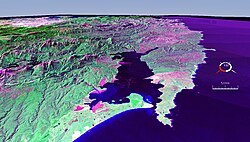
Macquarie Harbour is a shallow inlet located in the West Coast region of Tasmania, Australia. It is approximately 315 sq.km, and has an average depth of 15m, with deeper places up to 50m. It is navigable by shallow-draft vessels. The main channel is kept clear by the presence of a rock wall on the outside of the channel's curve. This man-made wall prevents erosion and keeps the channel deep and narrow, rather than allowing the channel to become wide and shallow. A reported Aboriginal name for the harbour is Parralaongatek.

The West Coast Range is a mountain range located in the West Coast region of Tasmania, Australia.

Hells Gates is the name of the mouth of Macquarie Harbour on the West Coast of Tasmania.

The South East Cape is a cape located at the southernmost point of the main island of Tasmania, the southernmost state of Australia. The cape is situated in the southern and south-eastern corner of the Southwest National Park, part of the Tasmanian Wilderness World Heritage Area, approximately 94 kilometres (58 mi) southwest of Hobart in Tasmania and about 65 kilometres (40 mi) east and a little south of the South West Cape.
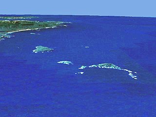
The Maatsuyker Islands are a group of islands and rocks located 5.5 kilometres (3.4 mi) off the south coast of Tasmania, Australia. Maatsuyker Island is the southernmost island of the group and of the Australian continental shelf. There are exposed rocks further south of Maatsuyker but they do not meet the definition of "islands". Macquarie Island, far to the south, is also Australian territory but it is an upthrust piece of ocean floor in the remote Southern Ocean and is in a geological sense completely separate from the continent.

Maatsuyker Island is an island located close to the south coast of Tasmania, Australia. The 186-hectare (0.72 sq mi) island is part of the Maatsuyker Islands Group, and comprises part of the Southwest National Park and the Tasmanian Wilderness World Heritage Site.

South West Rocks is a town located on the Mid North Coast of New South Wales, Australia, near the mouth of the Macleay River. It is approximately 40 km (25 mi) from Kempsey. Jerseyville is located nearby.
Mount Sorell is a mountain located in the West Coast region of Tasmania, Australia.
Ocean Beach is a long stretch of beach running north of Macquarie Heads and Hells Gates on the West Coast of Tasmania. It is close to Strahan and parallel to the Strahan Airport runway. It extends as far north as Trial Harbour and the coast immediately west of Zeehan.
The Cape Sorell Waverider Buoy, also named Captain Fathom by the listeners of ABC Radio, Tasmania during May 2015 to mark the centenary of the Bureau of Meteorology, is a swell-measuring buoy located west of Cape Sorell some 10 kilometres (6.2 mi) west of Ocean Beach in western Tasmania.
Green Cape is a locality situated on the eponymous headland or cape on the far south coast of New South Wales. It is located at 37° 15' S 150° 03' E, within Ben Boyd National Park, south of Eden, New South Wales. The headland forms the northern boundary of Disaster Bay.
The Low Rocky Point is a location on the south west coast of Tasmania and Australia, that is used as a location for weather forecasting. It is almost due west of Hobart, it is south of Point Hibbs and north of South West Cape.

Bonnet Island is a low island with an area of 2.21 ha. It lies at the entrance to Macquarie Harbour in Western Tasmania Australia, in the vicinity of Hells Gates. Due to its location and proximity to the entrance, it was involved as part the Macquarie Harbour Breakwater construction.

Smoky Cape Lighthouse is a heritage-listed active lighthouse located on Smoky Cape, a headland in Arakoon east of the town of South West Rocks, Kempsey Shire, New South Wales, Australia, and within the Hat Head National Park. It directs boats towards the entrance to the Macleay River, which is located just to the north of the lighthouse.
The Macquarie Heads Breakwater was a project of the Strahan Marine Board in Western Tasmania to sustain a reasonable depth to the Hells Gates and Macquarie Heads of the Macquarie Harbour area to allow for shipping of limited tonnage to serve Regatta Point while the Mount Lyell Mining and Railway Company was exporting its mineral products by sea. The heads were notoriously difficult to navigate in good weather, and even more difficult in bad weather.
Point Hibbs is a headland on the south-west coast of Tasmania, Australia. The headland is located south of the most southern point of Macquarie Harbour, and west of the Gordon River. It is the next named feature along the coast south of Cape Sorell that is used to delineate sections of the coast. Like South West Cape, it is used as a reference point for nearby wrecks.
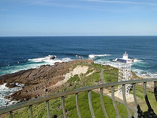
The Cape Sorell Lighthouse is a heritage-listed lighthouse that is located on Cape Sorell in the West Coast region of Tasmania, Australia. The lighthouse is situated approximately 12 kilometres (7.5 mi) southwest of Strahan.
Bird River, Tasmania is a short river that drains in the area of South Darwin Peak at the southern end of the West Coast Range, into Macquarie Harbour in Western Tasmania, Australia.
Macquarie Heads is a rural locality in the local government area of West Coast in the West Coast region of Tasmania. The locality is on the western side of the entrance to Macquarie Harbour and has no road access. The headland on the eastern side of the entrance is in the locality of Strahan, but is known locally as Macquarie Heads. It is located about 14 kilometres (8.7 mi) south-west of the town of Strahan. The 2016 census contains no information for the state suburb of Macquarie Heads.