Linda, Tasmania

Last updated

Linda
Tasmania
Royal Hotel, Linda.jpg
The Royal Hotel at Linda finally closed in the 1950s
Australia Tasmania location map.svg
Red pog.svg
Linda
Coordinates 42°03′50″S145°36′10″E / 42.06389°S 145.60278°E / -42.06389; 145.60278 Coordinates: 42°03′50″S145°36′10″E / 42.06389°S 145.60278°E / -42.06389; 145.60278

Linda is the site of an old ghost town in the Linda Valley in the West Coast Range of Tasmania, Australia. It has also been known as Linda Valley.

Contents

North Mount Lyell

There had been a location or community high on the ridge between Mount Owen and Mount Lyell above the Linda Valley to the west known as North Mount Lyell and in Blainey's The Peaks of Lyell, the photograph has the caption "The site of North Lyell town, blasted away to form the modern open cut". [1]

When North Mount Lyell was taken over by Mount Lyell Mining and Railway Company in 1903, Linda was quickly reduced in significance. Eventually most residents moved to either Gormanston, or Queenstown the nearby Mount Lyell towns.

Facilities

Linda Post Office opened on 18 December 1899 and closed in 1966. [2] The Royal Hotel was built during 1901, was destroyed by fire in 1910 and rebuilt. The property was left derelict after 1952 and re-sold in 2020. [3]

Linda railway station

Linda railway station [4] was the terminus of the Linda aerial ropeway [5] and the North Mount Lyell Railway when it was in operation.

Copper ore was taken from the mine to smelters at Crotty (now under the waters of Lake Burbury) then the refined metal taken to a port at Pillinger on the shores of Macquarie Harbour at Kelly Basin.

The remains of the town are now adjacent to the Lyell Highway east of Queenstown. [6]

See also

Related Research Articles

<span class="mw-page-title-main">Queenstown, Tasmania</span> Town in Tasmania, Australia

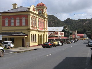
Queenstown is a town in the West Coast region of the island of Tasmania, Australia. It is in a valley on the western slopes of Mount Owen on the West Coast Range.

Rosebery is a town on the west coast of Tasmania, Australia. It is at the northern end of the West Coast Range, in the shadow of Mount Black and adjacent to the Pieman River now Lake Pieman.

<span class="mw-page-title-main">West Coast Range</span> Mountain range in Tasmania, Australia

The West Coast Range is a mountain range located in the West Coast region of Tasmania, Australia.

Mount Lyell is a mountain in the West Coast Range of Western Tasmania, Australia.

Mount Lyell Mining and Railway Company was a Tasmanian mining company formed on 29 March 1893, most commonly referred to as Mount Lyell. Mount Lyell was the dominant copper mining company of the West Coast from 1893 to 1994, and was based in Queenstown, Tasmania.

The North Mount Lyell disaster refers to a fire that broke out on 12 October 1912 at the Mount Lyell Mining and Railway Company operations on the West Coast of Tasmania, killing 42 miners. The mine had been taken over from the North Mount Lyell Company in 1903.

Gormanston is a town in Tasmania on the slopes of Mount Owen, above the town of Queenstown in Tasmania's West Coast. In the 2016 census, Gormanston had a population of 17.

Crotty is a former gazetted townsite that was located in Western Tasmania, Australia. The township was located on the eastern lower slopes of Mount Jukes, below the West Coast Range, and on the southern bank of the King River. The locality had had a former name of King River

<span class="mw-page-title-main">North Mount Lyell Railway</span> Former railway company in Tasmania, Australia

The North Mount Lyell Railway was built to operate between the North Mount Lyell mine in West Coast Tasmania and Pillinger in the Kelly Basin of Macquarie Harbour.

<span class="mw-page-title-main">Mount Owen (Tasmania)</span> Mountain in Tasmania, Australia

Mount Owen is a mountain directly east of the town of Queenstown on the West Coast Range in Western Tasmania, Australia.

<span class="mw-page-title-main">Queen River, Tasmania</span> River in Tasmania, Australia

The Queen River, part of the King River catchment, is a minor perennial river located in the West Coast region of Tasmania, Australia.

<span class="mw-page-title-main">Lake Burbury</span> Lake in Tasmania, Australia

Lake Burbury is a man-made water reservoir created by the Crotty Dam inundating the upper King River valley that lies east of the West Coast Range. Discharge from the reservoir feeds the John Butters Hydroelectric Power Station, owned and operated by Hydro Tasmania.

Mount Jukes is a mountain located on the Jukes Range, a spur off the West Coast Range, in the West Coast region of Tasmania, Australia.

North Mount Lyell was the name of a mine, mining company, locality and former railway north of Gormanston on the southern slopes of Mount Lyell in the West Coast Range on the West Coast of Tasmania, and on to the ridge between Mount Lyell and Mount Owen.

Pillinger is an abandoned port and townsite in Kelly Basin, on the south eastern side of Macquarie Harbour on the West Coast of Tasmania.

<span class="mw-page-title-main">Linda Valley</span> Valley in West Coast Range, Tasmania, Australia

Linda Valley is a valley in the West Coast Range of Tasmania. It was earlier known as the Vale of Chamouni. It is located between Mount Owen and Mount Lyell.

The history of the Railways on the West Coast of Tasmania has fascinated enthusiasts from around the world, because of the combination of the harsh terrain in which the railways were created, and the unique nature of most of the lines.

<span class="mw-page-title-main">Darwin Dam</span> Dam in Tasmania, Australia

The Darwin Dam is an offstream earthfill embankment saddle dam without a spillway, located in Western Tasmania, Australia. The impounded reservoir, also formed by Crotty Dam, is called Lake Burbury.

<span class="mw-page-title-main">Iron Blow</span> Mine in Tasmania, Australia

Iron Blow was the site of the earliest major mining venture at Mount Lyell on the west coast of Tasmania, Australia in 1883.

<span class="mw-page-title-main">Philosophers Ridge</span> Ridge in Western Tasmania, Australia

Philosophers Ridge is the long spur that connects Mount Lyell and Mount Owen in the West Coast Range of Western Tasmania.

References

  1. photograph adjacent to page 206 of 1967 third edition Blainey, Geoffrey (1967), The peaks of Lyell (3rd ed.), Melbourne University Press, retrieved 9 April 2017
  2. Premier Postal History. "Post Office List". Premier Postal Auctions. Retrieved 16 June 2012.
  3. "Dying for a change? This ghost town hotel is up for sale". Australia: ABC News. 29 May 2020. Retrieved 13 January 2023.
  4. Also known as the Linda Valley Station "GORMANSTON NOTES". Zeehan and Dundas Herald . Vol. XVII, no. 96. Tasmania, Australia. 5 February 1906. p. 4. Retrieved 4 June 2016 via National Library of Australia.
  5. "NORTH LYELL". The Examiner (Tasmania) . Vol. LX, no. 154. 29 June 1900. p. 2 (DAILY). Retrieved 4 June 2016 via National Library of Australia.
  6. Wedd, Edward John (1987), Linda, ghost town of Mt. Lyell, E. Wedd], ISBN   978-0-7316-1336-6

Further reading