Related Research Articles

The Franklin River is a major perennial river located in the Central Highlands and western regions of Tasmania, Australia. The river is located in the Franklin-Gordon Wild Rivers National Park at the mid northern area of the Tasmanian Wilderness World Heritage Area. Its source is situated at the western edge of the Central Highlands and it flows west towards the West Coast.

Lake Pedder, once a glacial outwash lake, is a man-made impoundment and diversion lake located in the southwest of Tasmania, Australia. In addition to its natural catchment from the Frankland Range, the lake is formed by the 1972 damming of the Serpentine and Huon rivers by the Hydro Electric Commission of Tasmania for the purposes of hydroelectric power generation.

The Franklin Dam or Gordon-below-Franklin Dam project was a proposed dam on the Gordon River in Tasmania, Australia, that was never constructed. The movement that eventually led to the project's cancellation became one of the most significant environmental campaigns in Australian history.

The Gordon River is a major perennial river located in the central highlands, south-west, and western regions of Tasmania, Australia.

Strahan, is a small town and former port on the west coast of Tasmania. It is now a significant locality for tourism in the region.

Macquarie Harbour is a large, shallow, inlet, located in the West Coast region of Tasmania, Australia. It is approximately 315 sq.km, and has an average depth of 15m, with deeper places up to 50m. The inlet is navigable by shallow-draft vessels. The main channel is kept clear by the presence of a rock wall on the outside of the channel's curve. This man-made wall prevents erosion and keeps the channel deep and narrow, rather than allowing the channel to become wide and shallow. A reported Aboriginal name for the harbour is Parralaongatek.

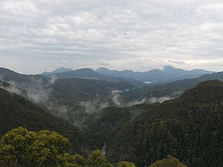
The West Coast Range is a mountain range located in the West Coast region of Tasmania, Australia.

The West Coast of Tasmania is mainly isolated rough country, associated with wilderness, mining and tourism. It served as the location of an early convict settlement in the early history of Van Diemen's Land, and contrasts sharply with the more developed and populous northern and eastern parts of the island state.

Kelly Basin is a bay on the south eastern side of Macquarie Harbour on the West Coast of Tasmania.

The South West Wilderness of Tasmania, Australia is a remote and inaccessible region of South West Tasmania containing unspoilt scenery, rugged peaks, wild rivers, unique flora and fauna, and a long and rugged coastline. Parts of the wilderness are more than 50 km from the nearest road, so the only access to the area is by foot, air or sea.
The Eldon Range is a mountain range located in the west coast region of Tasmania, Australia.
Teepookana was a short lived port, community and railway stopping place on the southern bank of the King River, in Western Tasmania.
South West Tasmania is a region in Tasmania that has evoked curiosity as to its resources over the duration of European presence on the island.
Port Davey is an oceanic inlet located in the south west region of Tasmania, Australia.
The Gordon Splits is a notable section of gorges of the Gordon River, located in South West Tasmania, Australia. The once impassable gorges are situated on the lower Gordon River in the Franklin-Gordon Wild Rivers National Park, part of the Tasmanian Wilderness World Heritage Area. The splits has also been an important location of focus within the larger environmental campaign for wilderness preservation in South West Tasmania.
The Serpentine River is a major perennial river located in the south-west and western regions of Tasmania, Australia.
The Scotts Peak Dam Road is the most southerly point of road access into the south western region of Tasmania, Australia.
The Port Davey Track, officially the Old Port Davey Track, is a bushwalking track located in the south western region of Tasmania, Australia. The 70-kilometre (43 mi) track traverses remote wilderness within the Southwest National Park, part of the Tasmanian Wilderness World Heritage Site, and is managed as a wilderness walk. The Tasmanian Parks & Wildlife Service recommend that experienced bushwalkers can take four-to-five days to cover the track in one direction.

The 2016 Tasmanian Bushfires were a large series of bushfires in Tasmania which started in January 2016 throughout the state, and continued into February 2016, with considerable damage to fire sensitive areas in the Central Highlands, West Coast and South West regions. By autumn 2016, no bushfires were reported within the state.
Geoff Law is an Tasmanian author, conservationist and environmental activist. He is author of works about conservation and environment in Tasmania.
References
- ↑ Tasmania. Land Information Bureau (1995), Engineer (Ed. 1 ed.), Tasmap, retrieved 17 June 2015
- ↑ Kerr, Garry and McDermott, Harry (1999) The Huon Pine Story Portland, Vic Mainsail Books ISBN 0-9577917-0-4. Map 4 page 34, and Chapter 3