
The Tin Mine Falls is a cascade waterfall located in the remote Pilot Wilderness Area within the Kosciuszko National Park in the Snowy Mountains region of New South Wales, Australia. Described from top to bottom, the falls consist of non-segmented tiered cascades over bedrock with a few smaller plunges, followed by a single large plunge into a pool. The falls are recessed into a punchbowl feature making it impossible to view the entire waterfall from a single location on the ground.
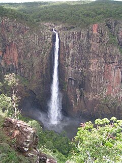
The Wallaman Falls, a cascade and horsetail waterfall on the Stony Creek, is located in the UNESCO World Heritage–listed Wet Tropics in the locality of Wallaman, Shire of Hinchinbrook in the northern region of Queensland, Australia. The waterfall is notable for its main drop of 268 metres (879 ft), which makes it the country's tallest single-drop waterfall. The pool at the bottom of the waterfall is 20 metres (66 ft) deep. An estimated 100,000 people visit the waterfall annually.
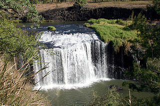
The Millstream Falls, a tiered plunge waterfall on The Millstream, is located in the UNESCO World Heritage–listed Wet Tropics in the Far North region of Queensland, Australia.

The Herbert River Falls is a plunge waterfall on the Herbert River that is located in the UNESCO World Heritage–listed Wet Tropics in the Far North region of Queensland, Australia.

The Purling Brook Falls or sometimes incorrectly Purlingbrook Falls, a horsetail waterfall on the Purling Brook, is located in the UNESCO World Heritage–listed Gondwana Rainforests in the South East region of Queensland, Australia.

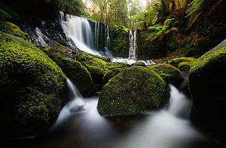
The Russell Falls, a tiered–cascade waterfall on the Russell Falls Creek, is located in the Central Highlands region of Tasmania, Australia.

The Montezuma Falls, a horsetail waterfall on a minor tributary to the Pieman River, is located on the West Coast Range of Tasmania, Australia.

The Liffey Falls, a series of four distinct tiered–cascade waterfalls on the Liffey River, is located in the Midlands region of Tasmania, Australia.

The Dip Falls, a cascade waterfall over cubic-basalt formed rocks on the Dip River, is located in Mawbanna in the North West region of Tasmania, Australia.
The Guide Falls and Upper Guide Falls, a tiered–cascade waterfall on the Guide River, is located in the North West region of Tasmania, Australia.
The Delaneys Falls, dually–named as the Preston Falls, a plunge waterfall on an unnamed watercourse, is located in the North West region of Tasmania, Australia.
The Horseshoe Falls, a tiered–cascade waterfall, is located in the Central Highlands region of Tasmania, Australia.
The Tchupala Falls, a segmented waterfall on the Henrietta Creek, is located in the UNESCO World Heritage–listed Wet Tropics in the Far North region of Queensland, Australia.
Mount Victoria is a mountain in the Mount Victoria Forest Reserve in north-east Tasmania, Australia, and also forms part of the Ben Lomond biogeographic region and the Ben Lomond National Park. The peak has an elevation of 1,213 metres (3,980 ft) above sea level and is the 58th highest mountain in Tasmania. It is a prominent feature of the reserve, and is a popular venue with bushwalkers.

The Lady Barron Falls, a tiered–cascade waterfall on the Lady Barron Creek, is located in the Central Highlands region of Tasmania, Australia.

The Silverband Falls are waterfalls located in the Grampians National Park, in western Victoria, Australia. Fed by Dairy Creek, the horsetail falls are characterised by a narrow band of water that tumbles over a small rock face and then disappears into a rocky base. The creek re-emerges some 50 metres (160 ft) west of the falls.

Preston is a village located in the Central Coast Council municipal area, near Upper Castra and Ulverstone in the North West region of Tasmania, Australia. In 2011, the village had an estimated population of 250.
The Supply River is a perennial river located in the northern region of Tasmania, Australia.

The Detention Falls, a cascade waterfall on the Detention River, is located at Milabena in North West Tasmania, Australia.
Vanishing Falls is a ledge waterfall in south-west Tasmania, Australia that drains into a sinkhole. It is located on the Salisbury River within the Southwest National Park.

