The Border Ranges National Park is a protected national park that is located in the Northern Rivers region of New South Wales, Australia. A small portion of the national park is also located in South East Queensland. The 31,729-hectare (78,400-acre) park is situated approximately 150 kilometres (93 mi) south of Brisbane, north of Kyogle.

The New England National Park is a protected national park located on the Northern Tablelands in the New England region of New South Wales, Australia. The 67,303-hectare (166,310-acre) park was created in May 1935 and is situated approximately 560 kilometres (350 mi) north of Sydney, and 10 kilometres (6.2 mi) south of Waterfall Way, just 85 kilometres (53 mi) east of Armidale and 65 kilometres (40 mi) west of Coffs Harbour. The closest village to New England National Park is Ebor, located 20 kilometres (12 mi) away.

The Springbrook National Park is a protected national park that is located in the Gold Coast hinterland of Queensland, Australia. The 6,197-hectare (15,310-acre) park is situated on the McPherson Range, near Springbrook, approximately 100 kilometres (62 mi) south of Brisbane. The park is part of the Shield Volcano Group of the UNESCO World Heritage–listed Gondwana Rainforests of Australia.

The Limpinwood Nature Reserve is a protected nature reserve that is located on the Northern Rivers region of New South Wales, in eastern Australia. The reserve was gazetted in April 1963 with additions made in 1967, over former fauna and crown reserves, and further additions were made in 1988 to make the reserve to its current area of 2,646 hectares. The reserve is situated north-west of the rural locality of Limpinwood, and north of Tyalgum and defines part of the state border between New South Wales and Queensland.

The McPherson Range is an extensive mountain range, a spur of the Great Dividing Range, heading in an easterly direction from near Wallangarra to the Pacific Ocean coastline. It forms part of the Scenic Rim on the border between the states of New South Wales and Queensland. Further west of the McPherson Range is the Main Range. Towards the coast the range continues into the Border Ranges and other mountainous terrain formed by the Tweed Volcano.

The Waterfall Way is a road in New South Wales, Australia. It runs east-west from the Pacific Highway to the New England Highway at Armidale. The route passes through some of New South Wales' most scenic countryside and has become well known as New South Wales best and Australia's third most beautiful tourist drive. Seven national parks, of which three are listed as World Heritage Areas by UNESCO and form part of the Gondwana Rainforests of Australia, are located on or close to the route. Dorrigo National Park encompasses the waterfalls that give the route its name. It also provides one of the few road links between coastal and inland New South Wales, and is therefore more heavily trafficked than its condition might otherwise suggest.

Binna Burra is a parcel of private land and mountain lodge surrounded by Lamington National Park in Queensland, Australia. It is also the name of a locality in the same area within the Scenic Rim Region. The lodge lies in the north-eastern corner of the Lamington Plateau in the McPherson Range, 75 kilometres (47 mi) south of Brisbane. It is marketed as an ecolodge and was one of the first nature based resorts to be established in Australia. In 2000, the resort was the first commercial accommodation provider to be awarded Green Globe Certification in Australia. The lodge and other aspects of the built environment at Binna Burra are listed on the Queensland Heritage Register as the Binna Burra Cultural Landscape.

The Murray Falls, a cascade waterfall on the Murray River, is located in the UNESCO World Heritage–listed Wet Tropics in Murray Upper, Cassowary Coast Region in the Far North region of Queensland, Australia.

The Purling Brook Falls or sometimes incorrectly Purlingbrook Falls, a horsetail waterfall on the Purling Brook, is located in the UNESCO World Heritage–listed Gondwana Rainforests in the South East region of Queensland, Australia.
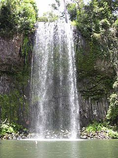
Millaa Millaa Falls is a heritage-listed plunge waterfall at Theresa Creek Road, Millaa Millaa, Tablelands Region, Queensland, Australia. It was added to the Queensland Heritage Register on 5 December 2005.

The Gold Coast hinterland is an area of South East Queensland, Australia that comprises the Tweed Range, Nimmel Range, Tamborine Mountain, Numinbah Valley, eastern parts of the McPherson Range and western parts of suburban Gold Coast, such as Mudgeeraba. This undefined unit of area is known for its tourist attractions including resorts, rainforest, lookouts, national parks, its diversity of fauna and flora and as a green backdrop to the coastal strip. It overlaps part of the Scenic Rim and is part of both the City of Gold Coast and Scenic Rim Region and includes Springbrook, Binna Burra and O'Reilly's Guesthouse.

The Coomera Falls is a segmented waterfall on the upper Coomera River in the South East region of Queensland, Australia.
The Yarrbilgong Falls, a waterfall on the Coomera River, is located within Lamington National Park in the South East region of Queensland, Australia.

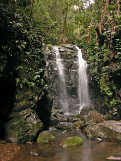
The Elabana Falls is a cascade waterfall that is located within Lamington National Park in the South East region of Queensland, Australia.

The Minyon Falls is a plunge waterfall on the Repentance Creek in the Northern Rivers region of New South Wales, Australia. The waterfall descends more than 100 metres (330 ft) over the huge rhyolite cliffs which were once part of the Tweed Volcano. The water flow eroded the underlying basalt away to create the waterfall.

O'Reilly is a locality in the Scenic Rim Region, Queensland, Australia. It is located on border between Queensland and New South Wales on the elevated Lamington Plateau. The plateau remains heavily vegetated by Gondwana Rainforests within the Lamington National Park which covers almost all of O'Reilly. The park contains a network of walking tracks, lookouts and numerous waterfalls. The mountain resort known as O'Reilly's Rainforest Retreat is a popular attraction.
Nugurun Falls is a small waterfall on West Canungra Creek, a tributary of the Logan River, in Queensland, Australia. The waterfall is located within the Green Mountains section of Lamington National Park, in the Scenic Rim Region, near the resort village of O'reillys. Like other waterfalls in the area, Nugurun Falls is surrounded by dense rainforest.
Box Log Falls is a large waterfall on West Canungra Creek, a tributary of the Logan River, in Queensland, Australia. The waterfall is located within the Green Mountains section of Lamington National Park, in the Scenic Rim Region, near the resort village of O'reillys. Like other waterfalls in the area, Box Log Falls is surrounded by dense rainforest, especially a large Brush Box stand.