Vanishing Falls (Tasmania)

Last updated

Vanishing Falls
Relief Map of Tasmania.png
Red pog.svg
Location South West Tasmania, Australia
Coordinates 43°23′33″S146°38′11″E / 43.39250°S 146.63639°E / -43.39250; 146.63639 Coordinates: 43°23′33″S146°38′11″E / 43.39250°S 146.63639°E / -43.39250; 146.63639 [1]
Type Ledge
Elevation390m [1]
Total height70 metres (230 ft) [2]
WatercourseSalisbury River

Vanishing Falls is a ledge waterfall in south-west Tasmania, Australia that drains into a sinkhole. It is located on the Salisbury River within the Southwest National Park.

South West Tasmania is a region in Tasmania that has evoked curiosity as to its resources over the duration of European presence on the island.

Tasmania island state of Australia

Tasmania is an island state of Australia. It is located 240 km (150 mi) to the south of the Australian mainland, separated by Bass Strait. The state encompasses the main island of Tasmania, the 26th-largest island in the world, and the surrounding 334 islands. The state has a population of around 533,308 as of March 2019. Just over forty percent of the population resides in the Greater Hobart precinct, which forms the metropolitan area of the state capital and largest city, Hobart.

Australia Country in Oceania

Australia, officially the Commonwealth of Australia, is a sovereign state comprising the mainland of the Australian continent, the island of Tasmania, and numerous smaller islands. It is the largest country in Oceania and the world's sixth-largest country by total area. The neighbouring countries are Papua New Guinea, Indonesia, and East Timor to the north; the Solomon Islands and Vanuatu to the north-east; and New Zealand to the south-east. The population of 26 million is highly urbanised and heavily concentrated on the eastern seaboard. Australia's capital is Canberra, and its largest city is Sydney. The country's other major metropolitan areas are Melbourne, Brisbane, Perth, and Adelaide.

Contents

Description

At Vanishing Falls, the Salisbury River flows over a dolerite plateau underlain by limestone. The river flows over the edge of the dolerite sill and drains straight into a cave system in the limestone, a phenomenon attributed to karst processes. The above-ground channel downstream of the plunge pool flows only during floods. [3]

Limestone Sedimentary rocks made of calcium carbonate

Limestone is a carbonate sedimentary rock that is often composed of the skeletal fragments of marine organisms such as coral, foraminifera, and molluscs. Its major materials are the minerals calcite and aragonite, which are different crystal forms of calcium carbonate (CaCO3). A closely related rock is dolomite, which contains a high percentage of the mineral dolomite, CaMg(CO3)2. In old USGS publications, dolomite was referred to as magnesian limestone, a term now reserved for magnesium-deficient dolomites or magnesium-rich limestones.

Sill (geology) geology term for a type of rock formation

In geology, a sill is a tabular sheet intrusion that has intruded between older layers of sedimentary rock, beds of volcanic lava or tuff, or along the direction of foliation in metamorphic rock. A sill is a concordant intrusive sheet, meaning that a sill does not cut across preexisting rock beds. Stacking of sills builds a sill complex and a large magma chamber at high magma flux. In contrast, a dike is a discordant intrusive sheet, which does cut across older rocks. Sills are fed by dikes, except in unusual locations where they form in nearly vertical beds attached directly to a magma source. The rocks must be brittle and fracture to create the planes along which the magma intrudes the parent rock bodies, whether this occurs along preexisting planes between sedimentary or volcanic beds or weakened planes related to foliation in metamorphic rock. These planes or weakened areas allow the intrusion of a thin sheet-like body of magma paralleling the existing bedding planes, concordant fracture zone, or foliations.

Karst Topography formed from the dissolution of soluble rocks

Karst is a topography formed from the dissolution of soluble rocks such as limestone, dolomite, and gypsum. It is characterized by underground drainage systems with sinkholes and caves. It has also been documented for more weathering-resistant rocks, such as quartzite, given the right conditions. Subterranean drainage may limit surface water, with few to no rivers or lakes. However, in regions where the dissolved bedrock is covered or confined by one or more superimposed non-soluble rock strata, distinctive karst features may occur only at subsurface levels and can be totally missing above ground.

The Salisbury River is a tributary of the New River. [1]

Access

The falls are surrounded by dense scrub and are located in remote wilderness, accordingly there are no designated trails leading to the falls. [4] [2]

See also

Protected areas of Tasmania consists of protected areas located within Tasmania and its immediate onshore waters, including Macquarie Island. It includes areas of crown land managed by Tasmanian Government agencies as well as private reserves. As of 2016, 52% of Tasmania's land area has some form of reservation classification, the majority is managed by the Tasmania Parks & Wildlife Service. Marine protected areas cover about 7.9% of state waters.

Related Research Articles

Kanangra-Boyd National Park Protected area in New South Wales, Australia

The Kanangra-Boyd National Park is a protected national park that is located in the Central Tablelands region, west of the Southern Highlands and Macarthur regions, in New South Wales, in eastern Australia. The 68,660-hectare (169,700-acre) national park is situated approximately 180 kilometres (110 mi) south-west of Sydney and is contiguous with the Blue Mountains National Park and the Nattai National Park. The park was established in 1969.

Wallaman Falls waterfall in Girringun National Park, Queensland, Australia

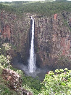
The Wallaman Falls, a cascade and horsetail waterfall on the Stony Creek, is located in the UNESCO World Heritage–listed Wet Tropics in the locality of Wallaman, Shire of Hinchinbrook in the northern region of Queensland, Australia. The waterfall is notable for its main drop of 268 metres (879 ft), which makes it the country's tallest single-drop waterfall. The pool at the bottom of the waterfall is 20 metres (66 ft) deep. An estimated 100,000 people visit the waterfall annually.

Herbert River river located in Far North Queensland, Australia

The Herbert River is a river located in Far North Queensland, Australia. The southernmost of Queensland's wet tropics river systems, it was named in 1864 by George Elphinstone Dalrymple explorer, after Robert George Wyndham Herbert, the first Premier of Queensland.

Josephine Falls waterfall

The Josephine Falls is a tiered cascade waterfall on the Josephine Creek located in Wooroonooran, Cairns Region in the Far North region of Queensland, Australia.

Malanda Falls

The Malanda Falls is a cascade waterfall on the North Johnstone River, located in the Tablelands Region in the Far North of Queensland, Australia.

Herbert River Falls waterfall in Queensland

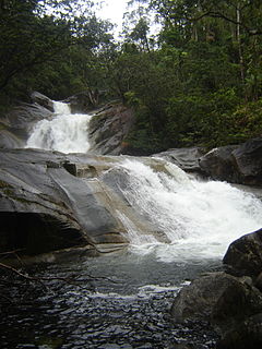
The Herbert River Falls is a plunge waterfall on the Herbert River that is located in the UNESCO World Heritage–listed Wet Tropics in the Far North region of Queensland, Australia.

Russell Falls waterfall in Tasmania, Australia

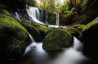
The Russell Falls, a tiered–cascade waterfall on the Russell Falls Creek, is located in the Central Highlands region of Tasmania, Australia.

Montezuma Falls

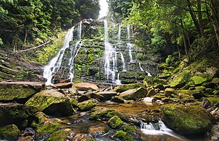
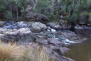
The Montezuma Falls, a horsetail waterfall on a minor tributary to the Pieman River, is located on the West Coast Range of Tasmania, Australia.

Liffey Falls

The Liffey Falls, a series of four distinct tiered–cascade waterfalls on the Liffey River, is located in the Midlands region of Tasmania, Australia.

Dip Falls waterfall in North West Tasmania, Australia

The Dip Falls, a cascade waterfall over cubic-basalt formed rocks on the Dip River, is located in Mawbanna in the North West region of Tasmania, Australia.

Guide Falls

The Guide Falls and Upper Guide Falls, a tiered–cascade waterfall on the Guide River, is located in the North West region of Tasmania, Australia.

Delaneys Falls

The Delaneys Falls, dually–named as the Preston Falls, a plunge waterfall on an unnamed watercourse, is located in the North West region of Tasmania, Australia.

Horseshoe Falls (Tasmania) waterfall in Tasmania, Australia

The Horseshoe Falls, a tiered–cascade waterfall, is located in the Central Highlands region of Tasmania, Australia.

Round Mountain (Northern Tablelands) mountain in New South Wales, Australia

Round Mountain, a mountain of the Snowy Range, a spur of the Great Dividing Range, is located on the Northern Tablelands in the New England region in New South Wales, Australia.

Tully Falls waterfall

The Tully Falls, a horsetail chute waterfall on the Tully River, is located in the UNESCO World Heritage–listed Wet Tropics in the Far North region of Queensland, Australia. It formed the eastern boundary of the Dyirbal.

Lady Barron Falls waterfall in Australia

The Lady Barron Falls, a tiered–cascade waterfall on the Lady Barron Creek, is located in the Central Highlands region of Tasmania, Australia.

King George River river in Australia

The King George River is a perennial river located in the Kimberley region of Western Australia, in Australia.

Nelson Falls cascade waterfall located in the West Coast region of Tasmania, Australia

The Nelson Falls, a cascade waterfall, is located in the UNESCO World Heritage–listed Tasmanian Wilderness, in the West Coast region of Tasmania, Australia.

Supply River River in Australia

The Supply River is a perennial river located in the northern region of Tasmania, Australia.

Detention Falls

The Detention Falls, a cascade waterfall on the Detention River, is located at Milabena in North West Tasmania, Australia.

References

  1. 1 2 3 "the LIST Map". Land Information System Tasmania (theLIST), Government of Tasmania. Search "Vanishing Falls". Retrieved 28 May 2017.
  2. 1 2 Dixon, Grant; Sharples, Chris (1986). "Reconnaissance Geological Observations on Precambrian and Palaeozoic Rocks of the New and Salisbury Rivers, Southern Tasmania" (PDF). University of Tasmania . Retrieved 28 May 2017.
  3. Jerie, Kathryn; Houshold, Ian; Peters, David (June 2003). "Tasmania's river geomorphology: stream character and regional analysis. Volume 1" (PDF). Department of Primary Industries, Water and Environment . Retrieved 27 May 2017.
  4. Meyer, Robert; Smith, Howard. "Skyline No. 23 - Vanishing Falls" (PDF). Launceston Walking Club. Retrieved 27 May 2017.

Further reading