| Josephine Falls | |
|---|---|
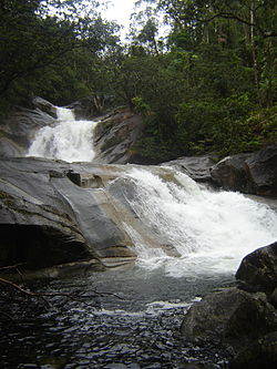 Josephine Falls | |
 | |
 | |
| Location | Far North Queensland, Australia |
| Coordinates | 17°25′46″S145°51′34″E / 17.42944°S 145.85944°E [1] [2] |
| Type | Tiered cascade |
| Elevation | 192 metres (630 ft) AHD [3] |
| Total height | 150–300 metres (490–980 ft) [3] |
| Number of drops | 3 |
| Watercourse | Josephine Creek |
The Josephine Falls is a tiered cascade waterfall on the Josephine Creek located in Wooroonooran, Cairns Region in the Far North region of Queensland, Australia.