The Undara Volcanic National Park is a national park in the Shire of Etheridge, Queensland, Australia. It is situated 275 kilometres southwest of Cairns just off the Gulf Developmental Road. The park was established in 2009 to protect Australia longest lava tube and the unique fauna and flora found of the area. The basalts of the area form part of the Cenozoic McBride Basalt (Volcanic) Provence. The volcanics are all less than 8 million year old (Ma) with the youngest only 7,000 years old.
The Curtain Fig National Park is a national park on the Atherton Tableland in Far North Queensland, Australia. The National Park is located near Yungaburra. Its most valued features are its once regionally common, now endangered Mabi forests including a huge strangler fig which attracts up to 100 000 visitors per year, locally known as the Curtain Fig Tree, plus a near threatened, locally endemic tree-kangaroo species i.e. the Lumholtz's tree-kangaroo which finds refuge inside this protected area

Volcanic cones are among the simplest volcanic landforms. They are built by ejecta from a volcanic vent, piling up around the vent in the shape of a cone with a central crater. Volcanic cones are of different types, depending upon the nature and size of the fragments ejected during the eruption. Types of volcanic cones include stratocones, spatter cones, tuff cones, and cinder cones.

Yungaburra is a rural town and locality in the Tablelands Region, Queensland, Australia. In the 2016 census the locality of Yungaburra had a population of 1,239 people.

Cinder Cone is a cinder cone volcano in Lassen Volcanic National Park within the United States. It is located about 10 miles (16 km) northeast of Lassen Peak and provides an excellent view of Brokeoff Mountain, Lassen Peak, and Chaos Crags.

Mount Washington is a deeply eroded volcano in the Cascade Range of Oregon. It lies within Deschutes and Linn counties and is surrounded by the Mount Washington Wilderness area.

Belknap Crater is a shield volcano in the Cascade Range in the U.S. state of Oregon. Located in Linn County, it is associated with lava fields and numerous subfeatures including the Little Belknap and South Belknap volcanic cones. It lies north of McKenzie Pass and forms part of the Mount Washington Wilderness. Belknap is not forested and most of its lava flows are not vegetated, though there is some wildlife in the area around the volcano, as well as a number of tree molds formed by its eruptive activity.

Scoria is a highly vesicular, dark-colored volcanic rock that may or may not contain crystals (phenocrysts). It is typically dark in color, and basaltic or andesitic in composition. Scoria is relatively low in density as a result of its numerous macroscopic ellipsoidal vesicles, but in contrast to pumice, all scoria has a specific gravity greater than 1, and sinks in water. The holes or vesicles form when gases that were dissolved in the magma come out of solution as it erupts, creating bubbles in the molten rock, some of which are frozen in place as the rock cools and solidifies. Scoria may form as part of a lava flow, typically near its surface, or as fragmental ejecta, for instance in Strombolian eruptions that form steep-sided scoria cones. Chemical analysis of scoria found in Yemen showed that it was mainly composed of volcanic glass with a few zeolites. Most scoria is composed of glassy fragments and may contain phenocrysts. The word scoria comes from the Greek σκωρία, skōria, rust. A colloquial term for scoria is cinder.
The Atherton Tableland is a fertile plateau which is part of the Great Dividing Range in Queensland, Australia.

Lake Barrine is a freshwater lake on the eastern parts of Atherton Tableland in the locality of Lake Barrine, in the Tablelands Region of Far North Queensland, Australia, close to Lake Eacham. The lake and surrounds are protected within the Crater Lakes National Park and are accessible via the Gillies Highway.

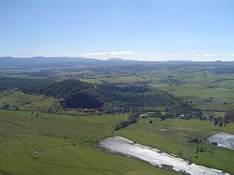
The Pinnacles are a series of seven volcanic cinder cones on the Atherton Tableland, near Yungaburra, Queensland, Australia. They were formed more than 350 000 years ago.

West Crater is a small lava dome with associated lava flows in southern Washington, United States. Located in Skamania County, it rises to an elevation of 4,131 feet (1,259 m), and forms part of the Cascade Volcanic Arc. It is also part of the Marble Mountain-Trout Creek Hill volcanic field, a little-known Quaternary volcanic field in the southern Cascades of Washington state. The area can be hiked, and can be accessed by roads in the Gifford Pinchot National Forest.

A cinder cone is a steep conical hill of loose pyroclastic fragments, such as volcanic clinkers, volcanic ash, or cinder that has been built around a volcanic vent. The pyroclastic fragments are formed by explosive eruptions or lava fountains from a single, typically cylindrical, vent. As the gas-charged lava is blown violently into the air, it breaks into small fragments that solidify and fall as either cinders, clinkers, or scoria around the vent to form a cone that often is symmetrical; with slopes between 30 and 40°; and a nearly circular ground plan. Most cinder cones have a bowl-shaped crater at the summit.

Blue Lake Crater is a maar, or a broad, low-relief volcanic crater, in the U.S. state of Oregon. Located in Jefferson County, it consists of three overlapping craters, which hold Blue Lake. The drainage basin for Blue Lake has very steep, forested slopes and is mostly part of the explosion crater left by the volcano's eruption. The volcano lies within the Metolius River basin, which supports a wide array of plant life, large and small mammals, and more than 80 bird species. In 2009, Governor of Oregon Ted Kulongoski signed a bill designating the Metolius River basin as an area of critical concern, preventing large-scale development on the land and protecting its wildlife.
Trout Creek Hill is a small Pleistocene basaltic shield volcano in Washington, United States. Located in Skamania County, Trout Creek Hill rises to an elevation of 2,946 feet (898 m). It is part of the Cascade Volcanic Arc, located in the Marble Mountain-Trout Creek Hill volcanic field.
Lynch's Crater formed about 230,000 years ago during an explosive volcanic eruption, creating a maar on the eastern edge of the Atherton Tableland in Queensland, Australia. Located at an altitude of about 760 m, the crater is about 80 m deep and has been heavily worn by erosion. Following its formation, a crater lake formed in the depression that was gradually filled in with deposits, so that the surface is now an average of 45 m beneath the rim. The present day interior is filled with swampy ground that is maintained by a stream flowing in from the eastern side. This water exits the crater to form a tributary of the North Johnstone River. The mean annual rainfall at this site is 2,500 mm.

Lake Eacham Hotel is a heritage-listed hotel at 6-8 Kehoe Place, Yungaburra, Tablelands Region, Queensland, Australia. It was built in 1910 by Side Brothers. It was added to the Queensland Heritage Register on 21 October 1992.

Ubehebe Craters is a volcanic field in California. In northern Death Valley, it consists of 14-16 craters in a 3-square-kilometre (1.2 sq mi) area. The largest of these craters is the 800 metres (2,600 ft) wide and 235 metres (771 ft) deep Ubehebe Crater, but many of these craters are partially buried and thus poorly recognizable. Additional volcanic features present include a remnant of a scoria cone as well as a tuff cone.
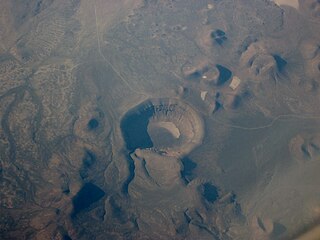
Lunar Crater volcanic field is a volcanic field in Nye County, Nevada. It lies along the Reveille and Pancake Ranges and consists of over 200 vents, mostly small volcanic cones with associated lava flows but also several maars, including one maar named Lunar Crater. Some vents have been eroded so heavily that the structures underneath the volcanoes have been exposed. Lunar Crater itself has been used as a testing ground for Mars rovers and as training ground for astronauts.