Barron Falls

Last updated

Barron Falls
Din Din
Barron falls january2005.JPG
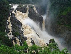
Barron Falls in the wet season.
Australia Queensland relief location map.jpg
Red pog.svg
Barron Falls
Location Kuranda, Queensland, Australia
Coordinates 16°50′19″S145°38′45″E / 16.83861°S 145.64583°E / -16.83861; 145.64583 [1] [2]
Type Steep Tiered Cascade
Total height125 metres (410 ft) [3]
Number of drops4
Longest drop107 metres (351 ft) [3]
Total width259 metres (850 ft) [3]
Average width137 metres (449 ft) [3]
Watercourse Barron River
Average
flow rate
30 cubic metres per second (1,100 cu ft/s) [3]

Barron Falls (Aboriginal: Din Din [4] ) is a steep tiered cascade waterfall in Kuranda, Shire of Mareeba, Queensland, Australia. [5] The falls are created by the Barron River descending from the Atherton Tablelands to the Cairns coastal plain. [3]

Contents

In 2009 as part of the Q150 celebrations, the Barron Falls was announced as one of the Q150 Icons of Queensland for its role as a "natural attraction". [6]

Location and features

Barron Falls in dry season. BarronFalls 4435.jpg
Barron Falls in dry season.

Protected within the Barron Gorge National Park, the volume of water seen in the upper photo only occurs after substantial rainfall during the wet season. For much of the rest of the year, little more than a trickle is evident, due in part to the presence of a weir behind the head of the falls that supplies the Barron Gorge Hydroelectric Power Station located downstream in the gorge.

The Barron Falls may be viewed and reached by road via the Kennedy Highway that crosses the Barron River upstream of the falls, near Kuranda. The narrow-gauge Kuranda Scenic Railway and the Skyrail aerial tram also lead from the coastal plain to the tablelands. The train stops at Barron Falls overlook, where passengers may disembark for several minutes. The Skyrail stops at two rainforest mid-stations, Red Peak and Barron Falls. The trail at Barron Falls Skyrail station leads through the rainforest to three separate lookouts providing views of the Gorge and Falls. [7]

Etymology

Video of Barron Falls in flood, January 2009

The falls were named for Thomas Henry Bowman Barron, the Chief Clerk of Police in Brisbane in the 1860s. [3]

Tourist attraction

The falls were one of the most popular tourist attractions in Queensland by the 1890s. Visitors are drawn to the natural features and scenery. [4]

See also

Related Research Articles

<span class="mw-page-title-main">Barron Gorge National Park</span> Protected area in Queensland, Australia

Barron Gorge National Park is a protected area in the Cairns Region, Queensland, Australia. It lies predominantly within the locality of Barron Gorge.

<span class="mw-page-title-main">Wallaman Falls</span> Waterfall on Stony Creek in Queensland, Australia

The Wallaman Falls, a cascade and horsetail waterfall on the Stony Creek, is located in the UNESCO World Heritage–listed Wet Tropics in the locality of Wallaman, Shire of Hinchinbrook in the northern region of Queensland, Australia. The waterfall is notable for its main drop of 268 metres (879 ft), which makes it the country's tallest single-drop waterfall. The pool at the bottom of the waterfall is 20 metres (66 ft) deep. An estimated 100,000 people visit the waterfall annually.

<span class="mw-page-title-main">Kuranda, Queensland</span> Town in Queensland, Australia

Kuranda is a rural town and locality on the Atherton Tableland in the Shire of Mareeba, Queensland, Australia. In the 2016 census, Kuranda had a population of 3,008 people. It is 25 kilometres (16 mi) from Cairns, via the Kuranda Range road. It is surrounded by tropical rainforest and adjacent to the Wet Tropics of Queensland World Heritage listed Barron Gorge National Park.

<span class="mw-page-title-main">Mareeba</span> Town in Queensland, Australia

Mareeba is a rural town and locality in the Shire of Mareeba in Far North Queensland, Australia. Between 2008 and 2013, it was within the Tablelands Region. The town's name is derived from an Aboriginal word meaning meeting of the waters. In the 2021 census, the locality of Mareeba had a population of 11,825 people.

<span class="mw-page-title-main">Barron River (Queensland)</span> River in Queensland, Australia

The Barron River is located on the Atherton Tablelands inland from Cairns in North Queensland, Australia. With its headwaters below Mount Hypipamee, the 165-kilometre (103 mi)-long river with a catchment area of approximately 2,138 square kilometres (825 sq mi) forms through run off from the Mount Hypipamee National Park, flows through Lake Tinaroo, and eventually empties into the Coral Sea between Machans Beach and Aeroglen.

<span class="mw-page-title-main">Skyrail Rainforest Cableway</span>

Skyrail Rainforest Cableway is a 7.5-kilometre (4.7 mi) scenic tourist cableway running above the Barron Gorge National Park, in the Wet Tropics of Queensland’s World Heritage Area in Australia. It operates from the Smithfield terminal in Cairns to the Kuranda terminal on the Atherton Tableland. It has won more than 25 awards.

<span class="mw-page-title-main">Far North Queensland</span> Region in Queensland, Australia

Far North Queensland (FNQ) is the northernmost part of the Australian state of Queensland. Its largest city is Cairns and it is dominated geographically by Cape York Peninsula, which stretches north to the Torres Strait, and west to the Gulf Country. The waters of Torres Strait include the only international border in the area contiguous with the Australian mainland, between Australia and Papua New Guinea.

<span class="mw-page-title-main">Millstream Falls</span> Waterfall in Far North Queensland, Australia

The Millstream Falls, a tiered plunge waterfall on The Millstream, is located in the UNESCO World Heritage–listed Wet Tropics in the Far North region of Queensland, Australia.

The Herbert River Falls is a plunge waterfall on the Herbert River that is located in the UNESCO World Heritage–listed Wet Tropics in the Far North region of Queensland, Australia.

<span class="mw-page-title-main">Stoney Creek Falls</span> Waterfall in Queensland, Australia

The Stoney Creek Falls is a cascade waterfall on the Stoney Creek located where the river descends from the Atherton Tablelands to the Cairns coastal plain, in Queensland, Australia.

<span class="mw-page-title-main">Djabugay</span> Australian Aboriginal people

The Djabugay people are a group of Aboriginal Australian people who are the original inhabitants of mountains, gorges, lands and waters of a richly forested part of the Great Dividing Range including the Barron Gorge and surrounding areas within the Wet Tropics of Queensland.

<span class="mw-page-title-main">Shire of Mareeba</span> Local government area in Queensland, Australia

The Shire of Mareeba is a local government area at the base of Cape York Peninsula in Far North Queensland, inland from Cairns. The shire, administered from the town of Mareeba, covered an area of 53,491 square kilometres (20,653.0 sq mi), and existed as a local government entity from 1879 until 2008, when it amalgamated with several councils in the Atherton Tableland area to become the Tablelands Region.

<span class="mw-page-title-main">Kuranda Scenic Railway</span>

The Kuranda Scenic Railway is a tourist railway service that operates along the heritage-listed Cairns-to-Kuranda railway line. Constructed in 1891, the line runs from Cairns, Queensland, over the Great Dividing Range to the town of Kuranda on the Atherton Tableland. Along the way, the route passes through the Macalister Range, as well as the suburbs of Stratford, Freshwater and Redlynch. Along the way, the train also stops at a lookout, which provides views of Barron Falls.

<span class="mw-page-title-main">Kuranda Range road</span>

The Kuranda Range road is an informally named section of the Kennedy Highway in Queensland, Australia. The road traverses the Macalister Range near Cairns. The 11.5 kilometres (7.1 mi) section of road connects Smithfield, a suburb of Cairns in the Cairns Region with Kuranda, a town in the Shire of Mareeba on the Atherton Tableland, at an altitude of about 360 metres (1,180 ft). Traffic is primarily limited to one lane each way, with overtaking lanes at various points. The Kuranda Skyrail cableway crosses the road twice. Henry Ross Lookout is located near the road's highest point, at an altitude of 430 metres (1,410 ft), and is named after the foreman in charge of building the road to cross the range in 1939.

<span class="mw-page-title-main">Tully Falls</span> Waterfall in Far North Queensland, Australia

The Tully Falls, a horsetail chute waterfall on the Tully River, is located in the UNESCO World Heritage–listed Wet Tropics in the Far North region of Queensland, Australia. It formed the eastern boundary of the Dyirbal.

<span class="mw-page-title-main">Kuranda National Park</span> Protected area in Queensland, Australia

Kuranda National Park is a national park in Far North Queensland, Australia. Like many national parks in the area it belongs to the Wet Tropics World Heritage Area. The park protects an important wildlife corridor in which rainforest and open eucalypt forest predominate. Walking, mountain biking and four-wheel driving are popular recreational activities.

<span class="mw-page-title-main">Cairns-to-Kuranda railway line</span> Railway line in Queensland, Australia

The Cairns-to-Kuranda Railway is a heritage-listed railway line from the Cairns Region to the Shire of Mareeba, both in Queensland, Australia. It commences at Redlynch, a suburb of Cairns and travels up the Great Dividing Range to Kuranda within the Shire of Mareeba on the Atherton Tableland. It was built from 1913 to 1915 by Queensland Railways. Components of it include Stoney Creek Bridge, the Rail Bridge over Christmas Creek, Kuranda railway station, and Surprise Creek Rail Bridge. It was added to the Queensland Heritage Register on 21 August 1992. The railway is used to operate a tourist rail service, the Kuranda Scenic Railway. It forms part of the Tablelands railway line.

<span class="mw-page-title-main">Barron Gorge, Queensland</span> Suburb of Cairns Region, Queensland, Australia

Barron Gorge is a rural locality in the Cairns Region, Queensland, Australia. In the 2016 census Barron Gorge had a population of 0 people.

<span class="mw-page-title-main">Macalister Range, Queensland</span> Suburb of Cairns Region, Queensland, Australia

Macalister Range is a coastal locality in the Cairns Region, Queensland, Australia. In the 2021 census, Macalister Range had a population of 0 people.

<span class="mw-page-title-main">Kuranda Fig Tree Avenue</span> Historic site in Queensland, Australia

Kuranda Fig Tree Avenue is a heritage-listed avenue of trees at Coondoo Street, Kuranda, Shire of Mareeba, Queensland, Australia. It was built in 1931. It is also known as Avenue of Ficus Microcarpa and Ficus Obliqua trees. It was added to the Queensland Heritage Register on 27 July 2018.

References

  1. "Barron Falls (QLD)". Gazetteer of Australia online. Geoscience Australia, Australian Government.
  2. "Barron Falls (QLD)". Gazetteer of Australia online. Geoscience Australia, Australian Government.
  3. 1 2 3 4 5 6 7 "Barron Falls". World Waterfall Database. 2014. Archived from the original on 11 June 2011. Retrieved 18 May 2014.
  4. 1 2 Julie Carmody & Bruce Prideaux. "Sustainable Nature Based Tourism: Planning and Management. Report on Visitation and Use at Barron Falls, Far North Queensland 2009/10" (PDF). Wet Tropics Site Report 5/10. Reef and Rainforest Research Centre Limited, Cairns. Retrieved 9 September 2015.
  5. "Barron Falls – waterfall in the Shire of Mareeba (entry 1761)". Queensland Place Names. Queensland Government . Retrieved 3 August 2023.
  6. Bligh, Anna (10 June 2009). "PREMIER UNVEILS QUEENSLAND'S 150 ICONS". Queensland Government. Archived from the original on 24 May 2017. Retrieved 24 May 2017.
  7. "Barron Falls Station". Skyrail Rainforest Cableway. Archived from the original on 5 July 2008.

Commons-logo.svg Media related to Barron Falls at Wikimedia Commons