
Ebor is a village on Waterfall Way on the Northern Tablelands in New South Wales, Australia. It is situated about 80 km (50 mi) east of Armidale and about a third of the way between Armidale and the coast. Dorrigo to the east is 46 kilometres (29 mi) away with the Coffs Coast 55 kilometres (34 mi) away along Waterfall Way. In the 2016 census, Ebor's zone had a population of 166.
Protected areas of Tasmania consist of protected areas located within Tasmania and its immediate onshore waters, including Macquarie Island. It includes areas of crown land managed by Tasmanian Government agencies as well as private reserves. As of 2016, 52% of Tasmania's land area has some form of reservation classification, the majority is managed by the Tasmania Parks & Wildlife Service. Marine protected areas cover about 7.9% of state waters.

Boonoo Boonoo National Park is a national park in New South Wales, Australia, 571 km north of Sydney and 26 kilometres north east of Tenterfield off Mount Lindesay Road.
The Walls of Jerusalem National Park is a national park located in the Central Highlands region of Tasmania, Australia. The park is located approximately 144 km (89 mi) northwest of Hobart, east of the Cradle Mountain-Lake St Clair National Park, and west of the Central Plateau Conservation Area. It is south of Mole Creek, Tasmania, and Rowallan Lake. The national park forms part of the Tasmanian Wilderness World Heritage Area.
Gloucester National Park is a national park in Western Australia, 281 km south of Perth and about 3 km from Pemberton.

The Springbrook National Park is a protected national park that is located in the Gold Coast hinterland of Queensland, Australia. The 6,197-hectare (15,310-acre) park is situated on the McPherson Range, near Springbrook, approximately 100 kilometres (62 mi) south of Brisbane. The park is part of the Shield Volcano Group of the UNESCO World Heritage–listed Gondwana Rainforests of Australia.
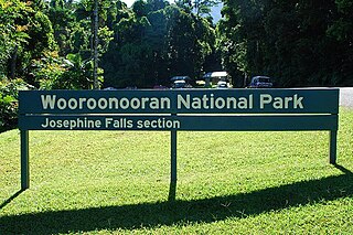
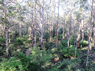
Wooroonooran [Aboriginal - "Black Rock"] is a national park in Queensland (Australia), 1367 km northwest of Brisbane, between Innisfail and Cairns.

The Overland Track is an Australian bushwalking track, traversing Cradle Mountain-Lake St Clair National Park, within the Tasmanian Wilderness World Heritage Area. It's walked by more than nine thousand people each year, with numbers limited in the warmer months. Officially the track runs for 65 kilometres (40 mi) from Cradle Mountain to Lake St Clair however many choose to extend it by walking along Lake St Clair for an extra day, bringing it to 82 kilometres (51 mi). It winds through terrain ranging from glacial mountains, temperate rainforest, wild rivers and alpine plains.

Cleland National Park, formerly Cleland Conservation Park, is a protected area located in the Adelaide Hills, South Australia about 22 kilometres (14 mi) south-east of the Adelaide city centre. It conserves a significant area of natural bushland on the Adelaide Hills face, including Mount Lofty Summit and Waterfall Gully.

The Murray Falls, a cascade waterfall on the Murray River, is located in the UNESCO World Heritage–listed Wet Tropics in Murray Upper, Cassowary Coast Region in the Far North region of Queensland, Australia.

The Blencoe Falls is a segmented waterfall on the Blencoe Creek, located in the Far North region of Queensland, Australia.
The Montezuma Falls, a horsetail waterfall on a minor tributary to the Pieman River, is located on the West Coast Range of Tasmania, Australia.

The Liffey Falls are a significant massacre site and a series of four distinct tiered–cascade waterfalls on the Liffey River. They are located in the Midlands region of lutruwita/Tasmania, Australia.

The Dip Falls, a cascade waterfall over cubic-basalt formed rocks on the Dip River, is located in Mawbanna in the North West region of Tasmania, Australia.

Milabena is a rural locality in the local government areas of Waratah-Wynyard and Circular Head in the North West region of Tasmania. It is located about 26 kilometres (16 mi) west of the town of Wynyard. First settled in the late 19th century it has been a centre for forestry, mixed agriculture especially potato growing and grazing dairy cattle. The 2016 census determined a population of 89 for the state suburb of Milabena.

The Guide Falls and Upper Guide Falls, a tiered–cascade waterfall on the Guide River, is located in the North West region of Tasmania, Australia.
Huon Commonwealth Marine Reserve is a 9,991 km2 marine protected area within Australian waters. The former Tasmanian Seamounts Marine Reserve created in 1999 was incorporated into the Huon reserve in 2007, and is part of the South-east Commonwealth Marine Reserve Network.

Western River Wilderness Protection Area, formerly the Western River Conservation Park and the Western River National Park, is a protected area in the Australian state of South Australia located on the north coast of Kangaroo Island about 30 kilometres (19 mi) west of Parndana in the gazetted locality of Western River. Waterfall Creek, with its scenic Billy Goat Waterfall, are within the area.

The Gibraltar Falls are a cascade waterfall on the Gibraltar Creek, in the Australian Capital Territory (ACT), approximately 50 kilometres from Canberra's city centre, The falls have a 50-metre (160-foot) drop.

Vanishing Falls is a ledge waterfall in south-west Tasmania, Australia that drains into a sinkhole. It is located on the Salisbury River within the Southwest National Park.
 Detention River at Detention Falls Conservation Area

