Shire of Etheridge

Last updated

Shire of Etheridge
Queensland
Etheridge LGA Qld.png
Location within Queensland
Population714 (2021 census) [1]
 • Density0.018215/km2 (0.04718/sq mi)
Established1879
Area39,199 km2 (15,134.8 sq mi) [2]
MayorBarry Gilbert Hughes
Council seat Georgetown
Region Far North Queensland
State electorate(s) Traeger
Federal division(s) Kennedy
Etheridge Shire Logo.jpg
Website Shire of Etheridge
LGAs around Shire of Etheridge:
Carpentaria Mareeba Tablelands
Croydon Shire of Etheridge Charters Towers
Richmond Flinders Charters Towers

The Shire of Etheridge is a local government area in Far North Queensland, Australia in what is known as the Savannah Gulf region. Its economy is based on cattle grazing and mining.

Contents

It covers an area of 39,199 square kilometres (15,134.8 sq mi), [2] and has existed as a local government entity since 1882.

In the 2021 census, the Shire of Etheridge had a population of 714 people. [1]

History

Map of Einasleigh Division and adjacent local government areas, March 1902 Einasleigh Division, March 1902.jpg
Map of Einasleigh Division and adjacent local government areas, March 1902

The Einasleigh Division was created on 11 November 1879 as one of 74 divisions around Queensland under the Divisional Boards Act 1879 with a population of 720. [3] [4] In 1891 it was reported that the divisional board had made no progress, perhaps because it covered a large area that was sparsely settled. [5]

With the passage of the Local Authorities Act 1902, Einasleigh Division became the Shire of Einasleigh on 31 March 1903. [4] [6]

On 15 March 1919, it was renamed Shire of Etheridge. [6]

Towns and localities

The Shire of Etheridge includes the following settlements:

Former towns and localities

The Etheridge Shire had many mines in the late 1800s. This gave rise to a number of communities that no longer exist today:

Amenities

The Etheridge Shire Council operate a public library at Georgetown. [7]

Demographics

YearPopulationNotes
19331,085[ citation needed ]
1947860[ citation needed ]
1954815[ citation needed ]
1961828[ citation needed ]
1966936[ citation needed ]
1971974[ citation needed ]
1976940[ citation needed ]
19811,010[ citation needed ]
19861,210[ citation needed ]
19911,377[ citation needed ]
19961,273[ citation needed ]
2001 census 1,431 [8]
2006 census 851 [9]
2011 census 893 [10]
2016 census 799 [11]
2021 census 714 [1]

Chairmen and mayors

Related Research Articles

<span class="mw-page-title-main">Shire of Paroo</span> Local government area in Queensland, Australia

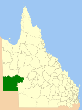
The Shire of Paroo is a local government area in South West Queensland, Australia. The administrative centre is the town of Cunnamulla. The Paroo Shire covers an area of 47,623 square kilometres (18,387 sq mi). In the 2021 census, the Shire of Paroo had a population of 1,679 people.

<span class="mw-page-title-main">Shire of Mareeba</span> Local government area in Queensland, Australia

The Shire of Mareeba is a local government area at the base of Cape York Peninsula in Far North Queensland, inland from Cairns. The shire, administered from the town of Mareeba, covered an area of 53,491 square kilometres (20,653.0 sq mi), and existed as a local government entity from 1879 until 2008, when it amalgamated with several councils in the Atherton Tableland area to become the Tablelands Region.

<span class="mw-page-title-main">Shire of Barcoo</span> Local government area in Queensland, Australia

The Shire of Barcoo is a local government area in Central West Queensland, Australia.

<span class="mw-page-title-main">Shire of Winton</span> Local government area in Queensland, Australia

The Shire of Winton is a local government area in Central West Queensland, Australia. It covers an area of 53,814 square kilometres (20,777.7 sq mi), and has existed as a local government entity since 1887. Its administrative centre is located in the town of Winton. It is named after Winton, Dorset, England, the birthplace of Robert Allen, the first white settler in the Winton (Queensland) area.

<span class="mw-page-title-main">Shire of Diamantina</span> Local government area in Queensland, Australia

The Shire of Diamantina is a local government area in Central West Queensland, bordering South Australia and the Northern Territory. Its administrative centre is in the town of Bedourie.

<span class="mw-page-title-main">Shire of McKinlay</span> Local government area in Queensland, Australia

The Shire of McKinlay is a local government area in outback north-western Queensland, Australia.

<span class="mw-page-title-main">Shire of Flinders (Queensland)</span> Local government area in Queensland, Australia

The Shire of Flinders is a local government area in north-western Queensland, Australia.

<span class="mw-page-title-main">Shire of Douglas</span> Local government area in Queensland, Australia

The Shire of Douglas is a local government area in Far North Queensland. It is located on the coast north of the city of Cairns. The shire, administered from the town of Mossman, covers an area of 2,428 square kilometres (937.5 sq mi), and existed as a local government entity from 1880 until 2008, when it was amalgamated with the City of Cairns to become the Cairns Region. Following a poll in 2013, the Shire of Douglas was re-established on 1 January 2014.

<span class="mw-page-title-main">Shire of Croydon</span> Local government area in Queensland, Australia

The Shire of Croydon is a local government area in western Queensland, Australia. The shire, administered from the town of Croydon, covers an area of 29,498 square kilometres (11,389.2 sq mi). The council consists of a mayor plus four councillors, each of whom represents the entire Shire.

<span class="mw-page-title-main">Shire of Cook</span> Local government area in Queensland, Australia

The Shire of Cook is a local government area in Far North Queensland, Australia. The Shire covers most of the eastern and central parts of Cape York Peninsula, the most northerly section of the Australian mainland.

<span class="mw-page-title-main">Shire of Torres</span> Local government area in Queensland, Australia

The Shire of Torres is a local government area located in Far North Queensland, Australia, covering large sections of the Torres Strait Islands and the northern tip of Cape York Peninsula north of 11°S latitude. It holds two distinctions—it is the northernmost Local Government Area in Australia, and is the only one to abut an international border – it is at one point just 73 kilometres (45 mi) from Papua New Guinea. It is administered from Thursday Island.

<span class="mw-page-title-main">Shire of Mornington (Queensland)</span> Local government area in Queensland, Australia

The Shire of Mornington is a local government area in northwestern Queensland, Australia. The shire covers the Wellesley Islands, which includes Mornington Island; the South Wellesley Islands; Bountiful Islands; and West Wellesley / Forsyth Islands groups in the Gulf of Carpentaria.

<span class="mw-page-title-main">Cassowary Coast Region</span> Local government area in Queensland, Australia

The Cassowary Coast Region is a local government area in the Far North Queensland region of Queensland, Australia, south of Cairns and centred on the towns of Innisfail, Cardwell and Tully. It was created in 2008 from a merger of the Shire of Cardwell and the Shire of Johnstone.

<span class="mw-page-title-main">Tablelands Region</span> Local government area in Queensland, Australia

The Tablelands Region is a local government area in Far North Queensland, Australia inland from the city of Cairns. Established in 2008, it was preceded by four previous local government areas which dated back more than a century. On 1 January 2014, one of those local government areas, the Shire of Mareeba, was re-established independent of the Tablelands Region.
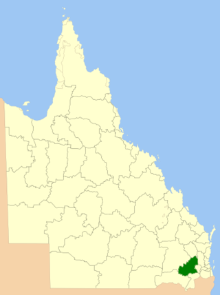
<span class="mw-page-title-main">Toowoomba Region</span> Local government area in Queensland, Australia

The Toowoomba Region is a local government area located in the Darling Downs part of Queensland, Australia. Established in 2008, it was preceded by several previous local government areas with histories extending back to the early 1900s and beyond.

<span class="mw-page-title-main">Charters Towers Region</span> Local government area in Queensland, Australia

The Charters Towers Region is a local government area in North Queensland, Australia southwest of, and inland from the city of Townsville, based in Charters Towers. Established in 2008, it was preceded by two previous local government areas which dated back to the 1870s.

<span class="mw-page-title-main">Southern Downs Region</span> Local government area in Queensland, Australia

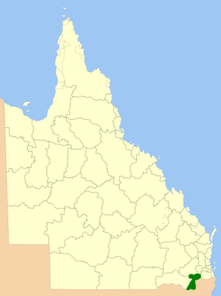
The Southern Downs Region is a local government area in the Darling Downs region of Queensland, Australia, along the state's boundary with New South Wales. It was created in 2008 from a merger of the Shire of Warwick and the Shire of Stanthorpe.

<span class="mw-page-title-main">Whitsunday Region</span> Local government area in Queensland, Australia

The Whitsunday Region is a local government area located in North Queensland, Australia. Established in 2008, it was preceded by two previous local government areas with a history extending back to the establishment of regional local government in Queensland in 1879.

<span class="mw-page-title-main">Gympie Region</span> Local government area in Queensland, Australia

The Gympie Region is a local government area in the Wide Bay–Burnett region of Queensland, Australia, about 170 kilometres (110 mi) north of Brisbane, the state capital. It is between the Sunshine Coast and Hervey Bay and centred on the town of Gympie. It was created in 2008 from a merger of the Shires of Cooloola and Kilkivan and part of the Shire of Tiaro.

<span class="mw-page-title-main">Aboriginal Shire of Yarrabah</span> Local government area in Queensland, Australia

The Aboriginal Shire of Yarrabah is a special local government area in Far North Queensland, Queensland, Australia, east and southeast of Cairns on Cape Grafton. It is managed under a Deed of Grant in Trust under the Local Government Act 2004.

References

  1. 1 2 3 Australian Bureau of Statistics (28 June 2022). "Shire of Etheridge (LGA)". 2021 Census QuickStats. Retrieved 28 February 2023. OOjs UI icon edit-ltr-progressive.svg
  2. 1 2 "3218.0 – Regional Population Growth, Australia, 2017-18: Population Estimates by Local Government Area (ASGS 2018), 2017 to 2018". Australian Bureau of Statistics. Australian Bureau of Statistics. 27 March 2019. Retrieved 25 October 2019. Estimated resident population, 30 June 2018.
  3. "Proclamation [Einasleigh Division]". Queensland Government Gazette . 11 November 1879. p. 25:1007.
  4. 1 2 "Agency ID 11113, Einasleigh Divisional Board". Queensland State Archives . Retrieved 24 September 2013.
  5. "Local Government Practically Applied". The Queenslander . 15 January 1881. p. 71. Retrieved 4 October 2013 via National Library of Australia.
  6. 1 2 "Agency ID 11076, Etheridge Shire Council". Queensland State Archives . Retrieved 24 September 2013.
  7. "Etheridge Shire Council". Public Libraries Connect. State Library of Queensland. 20 September 2016. Archived from the original on 5 February 2018. Retrieved 6 February 2018.
  8. Australian Bureau of Statistics (9 March 2006). "Shire of Etheridge (LGA)". 2001 Census QuickStats. Retrieved 22 June 2024. OOjs UI icon edit-ltr-progressive.svg
  9. Australian Bureau of Statistics (25 October 2007). "Shire of Etheridge (LGA)". 2006 Census QuickStats. Retrieved 22 June 2024.
  10. Australian Bureau of Statistics (31 October 2012). "Shire of Etheridge (LGA)". 2011 Census QuickStats. Retrieved 22 June 2024. OOjs UI icon edit-ltr-progressive.svg
  11. Australian Bureau of Statistics (27 June 2017). "Shire of Etheridge (LGA)". 2016 Census QuickStats. Retrieved 20 October 2018. OOjs UI icon edit-ltr-progressive.svg
  12. Consolidated Index to Queensland Government Gazette 1859-1919. Queensland Family History Society. 2004. ISBN   1-876613-79-3.
  13. Pugh, Theophilus Parsons (1927). Pugh's Almanac for 1927. Archived from the original on 4 March 2014. Retrieved 13 June 2014.
  14. "2008 Etheridge Shire - Mayoral Election - Election Summary". results.ecq.qld.gov.au. Archived from the original on 27 April 2018. Retrieved 4 December 2017.
  15. "2012 Etheridge Shire - Mayoral Election - Election Summary". results.ecq.qld.gov.au. Archived from the original on 1 April 2018. Retrieved 4 December 2017.
  16. "2016 Etheridge Shire Council - Mayoral Election - Election Summary". results.ecq.qld.gov.au. Archived from the original on 27 March 2018. Retrieved 4 December 2017.
  17. "2020 Local Government Elections: Saturday, 28 March 2020". Electoral Commission of Queensland. 2020. Retrieved 16 June 2020.[ dead link ]

18°17′27″S143°32′52″E / 18.29083°S 143.54778°E / -18.29083; 143.54778