Gilberton, Queensland (Etheridge Shire)

Last updated

Map all coordinates using: OpenStreetMap  
Download coordinates as: KML
Gilberton
Queensland
Australia Queensland location map.svg
Red pog.svg
Gilberton
Coordinates 19°16′26″S143°39′05″E / 19.2738°S 143.6513°E / -19.2738; 143.6513 (Gilberton (centre of locality)) Coordinates: 19°16′26″S143°39′05″E / 19.2738°S 143.6513°E / -19.2738; 143.6513 (Gilberton (centre of locality))
Population4 (2016 census) [1]
 • Density0.00100/km2 (0.0026/sq mi)
Postcode(s) 4871
Area3,995.9 km2 (1,542.8 sq mi)
Time zone AEST (UTC+10:00)
Location
LGA(s) Shire of Etheridge
State electorate(s) Traeger
Federal division(s) Kennedy
Localities around Gilberton:
Northhead Forsayth Lyndhurst
Bellfield Gilberton Lyndhurst
Woolgar Porcupine Lyndhurst

Gilberton is a rural locality in the Shire of Etheridge, Queensland, Australia. [2] In the 2016 census, Gilberton had a population of 4 people. [1]

Contents

Geography

The old Gilberton township lies within a cattle station (privately owned by one family since 1869, which was established on the Ewamian Aboriginal land. [3] The only remains of the town is the stone fortress that was built by the Martell family in 1869. The date palm on the northern side of the Gilbert River is the site of the Corbett store.

The Gilbert River flows from the south-east to the north-west of the locality and then travels northward towards its mouth at the Gulf of Carpentaria. Gilberton Station neighbors Rungullla National Park. [4]

The terrain is mountainous with the Newcastle Range in the north-east of the locality and Gilbert Range ( 19°20′00″S144°02′00″E / 19.3333°S 144.0333°E / -19.3333; 144.0333 (Gilbert Range) ) [5] in the east of the locality. There are a number of named peaks, from north to south:

History

The name Gilberton comes from the Gilbert River, which in turn was named by explorer Ludwig Leichhardt on 12 July 1845, after his expedition member John Gilbert who was killed near the Carpentaria coast on 28 June 1845. [2]

In the 2016 census, Gilberton had a population of 4 people. [1]

Heritage listings

Gilberton has a number of heritage-listed sites, including:

Education

There are no schools in Gilberton. The nearest primary school is Forsayth State School in neighbouring Forsayth to the north but it is a considerable distance away. There are no nearby secondary schools. Distance education or boarding schools would be options. [4]

Related Research Articles

Isisford, Queensland Town in Queensland, Australia

Isisford is a rural town and locality in the Longreach Region, Queensland, Australia. In the 2016 census, the locality of Isisford had a population of 218 people.

Lakeland, Queensland Town in Queensland, Australia

Lakeland is a rural town and locality in the Shire of Cook, Queensland, Australia. In the 2016 census, the locality of Lakeland had a population of 299 people.

Forsayth, Queensland Town in Queensland, Australia

Forsayth is a rural town and locality in the Shire of Etheridge, Queensland, Australia. In the 2016 census, Forsayth had a population of 129 people.

Georgetown, Queensland Town in Queensland, Australia

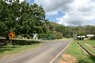
Georgetown is a town and locality in the Shire of Etheridge, Queensland, Australia. In the 2016 census, Georgetown had a population of 348 people.

Shire of Etheridge Local government area in Queensland, Australia

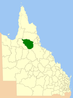
The Shire of Etheridge is a local government area in Far North Queensland, Australia in what is known as the Savannah Gulf region. Its economy is based on cattle grazing and mining.

Inkerman, Queensland Town in Queensland, Australia

Inkerman is a rural town and locality in the Shire of Burdekin, Queensland, Australia. In the 2016 census, the locality of Inkerman had a population of 145 people.

Mount Surprise, Queensland Town in Queensland, Australia

Mount Surprise is a rural town and locality in the Shire of Etheridge, Queensland, Australia. In the 2016 census the locality of Mount Surprise had a population of 169 people.

Irvinebank Town in Queensland, Australia

Irvinebank is a rural town and locality in the Shire of Mareeba, Queensland, Australia. In the 2016 census, the locality of Irvinebank had a population of 125 people.

Gilbert River is a rural locality in the Shire of Etheridge, Queensland, Australia. In the 2016 census Gilbert River had a population of 38 people.

Yarraden is a coastal rural locality in the Shire of Cook, Queensland, Australia. In the 2016 census Yarraden had a population of 11 people.

Lawn Hill, Queensland Suburb of Shire of Burke, Queensland, Australia

Lawn Hill is an outback locality split between the Shire of Burke and the City of Mount Isa in Queensland, Australia. The locality is on the Queensland border with the Northern Territory. In the 2016 census Lawn Hill had a population of 19 people.

Running Creek, Queensland Suburb of Scenic Rim Region, Queensland, Australia

Running Creek is a rural locality in the Scenic Rim Region, Queensland, Australia. In the 2016 census, Running Creek had a population of 147 people. It borders New South Wales.

Almaden, Queensland Town in Queensland, Australia

Almaden is a rural town and locality in the Shire of Mareeba, Queensland, Australia. In the 2016 census, the locality of Almaden had a population of 71 people.

Mount Moran Battery Historic site in Queensland, Australia

Mount Moran Battery is a heritage-listed former stamper battery at New Woolgar Road, Gilberton, Shire of Etheridge, Queensland, Australia. It was built from 1924 to c. 1936. It was added to the Queensland Heritage Register on 22 September 2000.

Mount Chalmers, Queensland Town in Queensland, Australia

Mount Chalmers is a rural town and locality in the Livingstone Shire, Queensland, Australia. In the 2016 census, the locality of Mount Chalmers had a population of 235 people.

The Caves, Queensland Town in Queensland, Australia

The Caves is a rural town and locality in the Livingstone Shire, Queensland, Australia. In the 2016 census the locality of The Caves had a population of 718 people.

Four Ways, Queensland Suburb of Shire of Cloncurry, Queensland, Australia

Four Ways is an outback locality in the Shire of Cloncurry, Queensland, Australia. In the 2016 census, Four Ways had a population of 15 people.

Spring Creek is a rural locality in the Shire of Banana, Queensland, Australia. In the 2016 census Spring Creek had a population of 15 people.

Lyndhurst is a locality in the Shire of Etheridge, Queensland, Australia. In the 2016 census, Lyndhurst had a population of 8 people.

Amber is a rural locality in the Shire of Mareeba, Queensland, Australia. In the 2016 census, Amber had a population of 0 people.

References

  1. 1 2 3 Australian Bureau of Statistics (27 June 2017). "Gilberton (SSC)". 2016 Census QuickStats. Retrieved 20 October 2018. OOjs UI icon edit-ltr-progressive.svg
  2. 1 2 "Gilberton – locality in Shire of Etheridge (entry 41674)". Queensland Place Names. Queensland Government . Retrieved 18 September 2020.
  3. "National Native Title Register Details". www.nntt.gov.au. Retrieved 8 June 2021.
  4. 1 2 "Queensland Globe". State of Queensland . Retrieved 30 October 2020.
  5. "Gilbert Range – range in Shire of Etheridge (entry 13734)". Queensland Place Names. Queensland Government . Retrieved 18 September 2020.
  6. "Mount Moran – mountain in Shire of Etheridge (entry 22773)". Queensland Place Names. Queensland Government . Retrieved 18 September 2020.
  7. "North Knob – peak in Shire of Etheridge (entry 24669)". Queensland Place Names. Queensland Government . Retrieved 18 September 2020.
  8. "Middle Knob – peak in Shire of Etheridge (entry 21969)". Queensland Place Names. Queensland Government . Retrieved 18 September 2020.
  9. "Conical Hill – hill in Shire of Etheridge (entry 7911)". Queensland Place Names. Queensland Government . Retrieved 18 September 2020.
  10. "Commissioners Hill – hill in Shire of Etheridge (entry 7847)". Queensland Place Names. Queensland Government . Retrieved 18 September 2020.
  11. "Hanns Table Mountain – mountain in Shire of Etheridge (entry 15343)". Queensland Place Names. Queensland Government . Retrieved 18 September 2020.
  12. "South Knob – peak in Shire of Etheridge (entry 31489)". Queensland Place Names. Queensland Government . Retrieved 18 September 2020.
  13. "Black Cap – mountain in Shire of Etheridge (entry 2799)". Queensland Place Names. Queensland Government . Retrieved 18 September 2020.
  14. "Mount Rous – mountain in Shire of Etheridge (entry 29227)". Queensland Place Names. Queensland Government . Retrieved 18 September 2020.
  15. "Mount Moran Battery (entry 601921)". Queensland Heritage Register . Queensland Heritage Council. Retrieved 7 July 2013.
  16. "Joseph Morris Mine (entry 601855)". Queensland Heritage Register . Queensland Heritage Council. Retrieved 7 July 2013.