Longreach Region

Last updated

Longreach Region
Queensland
Longreach LGA Qld 2008.png
Location within Queensland
Population3,660 (2016 census) [1]
 • Density0.09010/km2 (0.2334/sq mi)
Established2008
Area40,619.5 km2 (15,683.3 sq mi)
MayorTony Rayner
Council seat Longreach
Region Central West Queensland
State electorate(s) Gregory
Federal division(s) Maranoa
Longreach Regional Council Logo.gif
Website Longreach Region
LGAs around Longreach Region:
Winton Flinders Barcaldine
Winton Longreach Region Barcaldine
Barcoo Quilpie Blackall-Tambo

The Longreach Region is a local government area in Central West Queensland, Australia. Established in 2008, it superseded three previous local government areas that had existed for more than a century.

Contents

It has an estimated operating budget of A$22.3m.

Traditionally, pastoral activities, tourism, and rural education have been the areas of focus within the region, with a major agricultural college and attractions such as the Australian Stockman's Hall of Fame and the Qantas Founders Outback Museum.

History

Longreach Region lay on the traditional tribal lands of the Iningai. Iningai (also known as Yiningay, Muttaburra, Tateburra, Yinangay, Yinangi) is an Australian Aboriginal language spoken by the Iningai people. The Iningai language region includes the landscape within the local government boundaries of the Longreach Region, particularly the towns of Longreach, Barcaldine, Muttaburra and Aramac as well as the properties of Bowen Downs and catchments of Cornish Creek and Alice River. [2]

Kuungkari (also known as Kungkari and Koonkerri) is a language of Western Queensland. The Kuungkari language region includes the landscape within the local government boundaries of Longreach Shire Council and Blackall-Tambo Shire Council. [3]

Prior to the 2008 amalgamation, the Longreach Region existed as three distinct local government areas:

In July 2007, the Local Government Reform Commission released its report recommending that the three areas amalgamate. Ilfracombe was rated by a Treasury sustainability review as very weak with a negative outlook, while the other two were rated as moderate. All three councils opposed the amalgamation. [4] The legislation passed to effect the merger on 10 August 2007. A Local Transition Committee made up of staff and councillors of the three dissolving entities was formed to manage the process. On 15 March 2008, the three Shires formally ceased to exist, and elections were held on the same day to elect councillors and a mayor to the Regional Council.

In January 2019, it was decided to reduce the number of localities within Longreach Region by amalgamating the localities to the north and west of the town of Longreach into the locality of Longreach. The localities amalgamated were: Camoola, Chorregon, Ernestina, Maneroo, Morella, Tocal, and Vergemont. [5] As a consequence of this amalgamation, the Longreach Region has only three localities: Longreach, Ilframcombe and Isisford. [6]

On 10 September 2021, a new locality called Yaraka was created around the town of Yaraka, the land being excised from the locality of Isisford, to avoid confusion and restore historical connections. [7] [8] [9]

Council

Current composition

The current council, elected in 2020, is: [10]

WardCouncillorParty
Mayor Anthony Rayner Independent
Councillor Dale Bignell Independent
 Tony Emslie Independent
 Tracy Hatch Independent
 Tony Martin Independent
 Leonie Nunn Independent
 Trevor Smith Independent

Mayors

2008−present

No.PortraitMayorPartyTerm startTerm end
1 3x4.svg John Palmer Independent 15 March 2008 28 April 2012
2 3x4.svg R. L. "Joe" Owens Independent 28 April 2012 19 March 2016
2 3x4.svg Ed Warren Independent 19 March 2016 28 March 2020
4 3x4.svg Tony Rayner Independent 28 March 2020 incumbent

Past councillors

2008−2012 (six wards)

YearDivision 1Division 2Division 3Division 4Division 5Division 6
CouncillorPartyCouncillorPartyCouncillorPartyCouncillorPartyCouncillorPartyCouncillorParty
2008  Tony Nielsen Independent  Robert "Mick" Bischel Independent  Richard Murray Independent  Glennis Ford Independent  Norma Rae Bowden Independent  Ken Hoolihan Independent

2012−present (unsubdivided)

YearCouncillorPartyCouncillorPartyCouncillorPartyCouncillorPartyCouncillorPartyCouncillorParty
2012  Jocelyn Avery Independent  Norma Rae Bowden Independent  Tony Emslie Independent  David Morton Independent  Tony Nielsen Independent  Trevor Smith Independent
2016  Trevor Harris Independent  Tony Martin Independent  Leonie Nunn Independent  Anthony Rayner Independent
2020  Dale Bignell Independent  Tracy Hatch Independent

Towns and localities

The Longreach Region includes the following settlements:

Amenities

Longreach Regional Council operates public libraries at Ilfracombe, Isisford, and Longreach. [11]

Population

The populations given relate to the component entities prior to 2008 and combined population after amalgamation. The population has been in steady decline since the early 1960s.

YearPopulation
(Total)
(Longreach)(Ilfracombe)(Isisford)
19336,0794,564642873
19475,2444,137450657
19545,6944,343544807
19616,5335,013653867
19666,3664,959660747
19715,1424,300389453
19764,9114,052428431
19814,9113,846460605
19864,6633,871327465
19915,1534,369344440
19965,0544,419333302
20015,0374,368356313
20064,8064,180279347

Related Research Articles

<span class="mw-page-title-main">Longreach, Queensland</span> Town in Queensland, Australia

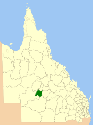
Longreach is a town and a locality in the Longreach Region, Queensland, Australia. It is the administrative centre of the Longreach Regional Council, which was established in 2008 as a merger of the former Longreach, Ilfracombe, and Isisford shires. Longreach is a well known tourist destination due to its aviation history and importance. In the 2021 census, the locality of Longreach had a population of 3,124 people.

<span class="mw-page-title-main">Barcaldine, Queensland</span> Town in Queensland, Australia

Barcaldine is a rural town and locality in the Barcaldine Region in Queensland, Australia. This is the administrative centre of the Barcaldine Region. Barcaldine played a major role in the Australian labour movement.

<span class="mw-page-title-main">Aramac, Queensland</span> Town in Queensland, Australia

Aramac is a rural town and locality in the Barcaldine Region, Queensland, Australia. In the 2016 census, Aramac had a population of 299 people.

<span class="mw-page-title-main">Isisford, Queensland</span> Town in Queensland, Australia

Isisford is a rural town and locality in the Longreach Region, Queensland, Australia. In the 2016 census, the locality of Isisford had a population of 218 people.

<span class="mw-page-title-main">Muttaburra</span> Town in Queensland, Australia

Muttaburra is an outback town and locality in the Barcaldine Region, Queensland, Australia. Muttaburra was the discovery site of the Muttaburrasaurus, one of Australia's most famous dinosaurs.

<span class="mw-page-title-main">Yaraka</span> Town in Queensland, Australia

Yaraka is a rural town and locality in the Longreach Region of Queensland, Australia. Until 2021, the town of Yaraka was part of the locality of Isisford.

<span class="mw-page-title-main">Ilfracombe, Queensland</span> Town in Queensland, Australia

Ilfracombe is a rural town and locality in the Longreach Region, Queensland, Australia. In the 2016 census, the locality of Ilfracombe had a population of 259 people.

<span class="mw-page-title-main">Shire of Barcoo</span> Local government area in Queensland, Australia

The Shire of Barcoo is a local government area in Central West Queensland, Australia. In June 2018, the shire had a population of 267 people.

<span class="mw-page-title-main">Shire of Ilfracombe</span> Local government area in Queensland, Australia

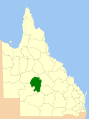
The Shire of Ilfracombe was a local government area located in central western Queensland, between the towns of Longreach and Barcaldine. Administered from the town of Ilfracombe, it covered an area of 6,575.5 square kilometres (2,538.8 sq mi), and existed as a local government entity from 1902 until 2008, when it amalgamated with the Shires of Isisford and Longreach to form the Longreach Region.

<span class="mw-page-title-main">Shire of Isisford</span> Local government area in Queensland, Australia

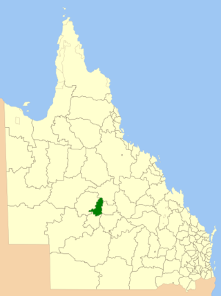
The Shire of Isisford was a local government area located in central western Queensland, between the towns of Longreach and Blackall. It covered an area of 10,482.6 square kilometres (4,047.4 sq mi), and existed as a local government entity from 1908 until 2008, when it amalgamated with the Shires of Ilfracombe and Longreach to form the Longreach Region.

<span class="mw-page-title-main">Shire of Longreach</span> Local government area in Queensland, Australia

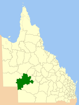
The Shire of Longreach was a local government area located in central western Queensland, centred on the town of Longreach, from which the shire was administered. It covered an area of 23,561.4 square kilometres (9,097.1 sq mi), and existed as a local government entity from 1900 until 2008, when it amalgamated with the Shires of Ilfracombe and Isisford to form the Longreach Region.

<span class="mw-page-title-main">Barcaldine Region</span> Local government area in Queensland, Australia

The Barcaldine Region is a local government area in Central West Queensland, Australia. Established in 2008, it was preceded by three previous local government areas which had existed for over a century.

<span class="mw-page-title-main">Blackall-Tambo Region</span> Local government area in Queensland, Australia

The Blackall-Tambo Region is a local government area in Central West Queensland, Australia. Established in 2008, it was preceded by two previous local government areas dating from the 1870s.

<span class="mw-page-title-main">Alice River (Barcoo River tributary)</span> River in Queensland, Australia

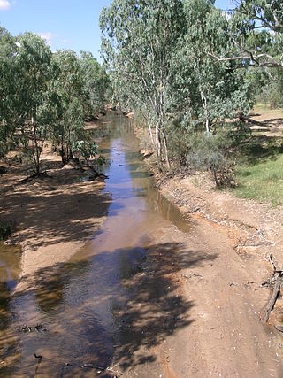
The Alice River in central Queensland, Australia rises on the western slopes of the Great Dividing Range. The river bisects the Shire of Barcaldine, flowing in a south-westerly direction towards Isisford and its confluence with the Barcoo River. The town of Barcaldine is located on the Alice River. The Alice River's tributaries include Jordan Creek and Lagoon Creek. The Alice River is often dry, except after the annual summer rains.

<span class="mw-page-title-main">Central West Queensland</span> Region in Queensland, Australia

Central West Queensland is a remote region in the Australian state of Queensland which covers 396,650.2 km2. The region lies to the north of South West Queensland and south of the Gulf Country. It has a population of approximately 12,387 people. As of 2018, it is one of 16 Aged Care Planning Regions (ACPR) in Queensland.

<span class="mw-page-title-main">Cornish Creek, Queensland</span> Suburb of Barcaldine Region, Queensland, Australia

Cornish Creek is a former rural locality in the Barcaldine Region, Queensland, Australia. In the 2016 census, Cornish Creek had a population of 16 people.

Camoola was a rural locality within the Longreach Region, Queensland, Australia, situated between the towns of Longreach and Muttaburra. It has been amalgamated into the locality of Longreach.

Sardine is a former rural locality in the Barcaldine Region, Queensland, Australia. In the 2016 census, Sardine had a population of 5 people.

<span class="mw-page-title-main">Barcaldine Downs</span> Suburb of Barcaldine Region, Queensland, Australia

Barcaldine Downs is a former rural locality in the Barcaldine Region, Queensland, Australia. In the 2016 census, Barcaldine Downs had a population of 14 people.

Tara Station is a former rural locality in the Barcaldine Region, Queensland, Australia. In the 2016 census, Tara Station had a population of 10 people.

References

  1. Australian Bureau of Statistics (27 June 2017). "Longreach (R)". 2016 Census QuickStats. Retrieved 26 November 2017. OOjs UI icon edit-ltr-progressive.svg
  2. "Iningai". State Library of Queensland . Archived from the original on 7 October 2020. Retrieved 15 January 2020.
  3. CC BY icon-80x15.png This Wikipedia article incorporates CC-BY-4.0 licensed text from: "Queensland Aboriginal and Torres Strait Islander languages map". State Library of Queensland. State Library of Queensland . Retrieved 30 January 2020.
  4. Queensland Local Government Reform Commission (July 2007). Report of the Local Government Reform Commission (PDF). Vol. 2. pp. 194–198. ISBN   978-1-921057-11-3. Archived (PDF) from the original on 17 March 2011. Retrieved 5 June 2010.
  5. "Recent place name decisions: Job number 17-050: Longreach". Queensland Government. Archived from the original on 28 July 2019. Retrieved 29 July 2019.{{cite web}}: CS1 maint: unfit URL (link)
  6. "Queensland Globe". State of Queensland . Retrieved 28 July 2019.
  7. "Recent place name decisions: Job number 19-027: Yaraka". Queensland Government. 10 September 2021. Archived from the original on 23 April 2020. Retrieved 7 February 2022.
  8. "Proposed Locality Names and Boundaries: Isisford and Yaraka" (PDF). Queensland Government. 14 May 2021. Archived (PDF) from the original on 16 July 2021. Retrieved 7 February 2022.
  9. "Locality Boundaries of Isisford and Yaraka" (PDF). Queensland Government. 10 September 2021. Archived (PDF) from the original on 7 February 2022. Retrieved 7 February 2022.
  10. "Electoral Commission Queensland". Electoral Commission Queensland. July 2019. Archived from the original on 7 February 2022. Retrieved 16 April 2020.
  11. "Longreach Regional Council". Public Libraries Connect. State Library of Queensland. 20 September 2016. Archived from the original on 6 February 2018. Retrieved 6 February 2018.