Maranoa Region

Last updated

Maranoa Region
Queensland
Roma LGA Qld 2008.png
Location in Queensland
Population12,791 (2018) [1]
 • Density0.217886/km2 (0.564322/sq mi)
Area58,705 km2 (22,666.1 sq mi) [1]
MayorWendy Taylor
Council seat Roma
Region Maranoa
State electorate(s) Warrego
Federal division(s) Maranoa
MaranoaRegionalCouncilLogo.jpg
Website Maranoa Region
LGAs around Maranoa Region:
Murweh Central Highlands Banana
Murweh Maranoa Region Western Downs
Paroo Balonne Western Downs

Maranoa Region is a local government area in South West Queensland, Australia. The town of Roma is the administrative headquarters of the region.

Contents

History

The Gunggari language region of South West Queensland includes the landscape within the local government boundaries of the Maranoa Region particularly the towns of Mitchell, Amby, Dunkeld and Mungallala and the properties of Forest Vale and North Yanco. [2]

Gungabula (also known as Kongabula and Khungabula) is an Australian Aboriginal language of the headwaters of the Dawson River in Central Queensland. The language region includes areas within the local government area of Maranoa Region, particularly the towns of Charleville, Augathella and Blackall and as well as the Carnarvon Range. [3]

On 17 May 1927, 57 allotments of Mount Abundance land, south-west of Roma, were advertised for lease by the Lands Department. Each lease carried a condition that a certain area had to be cultivated with wheat within a specified period. A map advertised the offer which ran from the 17 to 31 May 1927. [4] [5]

In July 2007, the Local Government Reform Commission released a report recommending a number of amalgamations of local government areas in Queensland. As a result, under the Local Government (Reform Implementation) Act 2007, on 15 March 2008, the new local government area of Roma Region was created, as an amalgamation of five previous local government areas: [6]

The report recommended that its people elect eight councillors and a mayor and it should not be divided into wards. The Maranoa Region covers an area of 58,705 square kilometres (22,666 sq mi), [1] and had a population in June 2018 of 12,791, [1] and has an operating budget of A$44.2m per annum.

On 26 July 2009, Roma Region was renamed Maranoa Region. [6]

Towns and localities

The Maranoa Region includes the following settlements:

Amenities

Maranoa Regional Council operates public libraries at Injune, Jackson, Mitchell, Mungallala, Roma, Surat, Wallumbilla, and Yuleba. [7]

Mayors

Related Research Articles

<span class="mw-page-title-main">Shire of Warroo</span> Local government area in Queensland, Australia

The Shire of Warroo was a local government area in the Darling Downs region of Queensland, Australia. In March 2008, it became part of the new Maranoa Region.

<span class="mw-page-title-main">Shire of Bendemere</span> Local government area in Queensland, Australia

The Shire of Bendemere was a local government area in the Maranoa region of Queensland, Australia, and existed from 1911 until 2008 when it amalgamated into Maranoa Region. The Shire, administered from the town of Yuleba, covered an area of 3,926.8 square kilometres (1,516.1 sq mi), and existed as a local government entity from 1911 until 2008, when it was amalgamated with the Town of Roma and the Shires of Booringa, Bungil and Warroo to form the Maranoa Region.

<span class="mw-page-title-main">Shire of Bungil</span> Local government area in Queensland, Australia

The Shire of Bungil was a local government area in the Maranoa region of Queensland, Australia. It existed from 1880 to 2008.

<span class="mw-page-title-main">Shire of Booringa</span> Local government area in Queensland, Australia

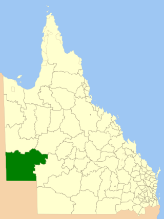
The Shire of Booringa was a local government area in the Maranoa region of Queensland, Australia. The largest town and home of the shire administration was Mitchell. It existed from 1879 to 2008. The shire is now part of the Maranoa Region.

<span class="mw-page-title-main">Shire of Diamantina</span> Local government area in Queensland, Australia

The Shire of Diamantina is a local government area in Central West Queensland, bordering South Australia and the Northern Territory. Its administrative centre is in the town of Bedourie.

<span class="mw-page-title-main">Shire of McKinlay</span> Local government area in Queensland, Australia

The Shire of McKinlay is a local government area in outback north-western Queensland, Australia.

<span class="mw-page-title-main">Shire of Douglas</span> Local government area in Queensland, Australia

The Shire of Douglas is a local government area in Far North Queensland. It is located on the coast north of the city of Cairns. The shire, administered from the town of Mossman, covers an area of 2,428 square kilometres (937.5 sq mi), and existed as a local government entity from 1880 until 2008, when it was amalgamated with the City of Cairns to become the Cairns Region. Following a poll in 2013, the Shire of Douglas was re-established on 1 January 2014.

<span class="mw-page-title-main">Shire of Cook</span> Local government area in Queensland, Australia

The Shire of Cook is a local government area in Far North Queensland, Australia. The Shire covers most of the eastern and central parts of Cape York Peninsula, the most northerly section of the Australian mainland.

<span class="mw-page-title-main">Town of Roma</span> Local government area in Queensland, Australia

The Town of Roma was a local government area in the western Downs region of Queensland, Australia. The Town of Roma covered the urban area of Roma and was surrounded by the neighbouring Shire of Bungil. Today it is part of the Maranoa Region. At the 2011 census the Town had a population of 6,906

<span class="mw-page-title-main">Aboriginal Shire of Doomadgee</span> Local government area in Queensland, Australia

The Aboriginal Shire of Doomadgee is a special local government area in North West Queensland, Queensland, Australia. It is managed under a Deed of Grant in Trust under the Local Government Act 2004.

<span class="mw-page-title-main">Isaac Region</span> Local government area in Queensland, Australia

The Isaac Region is a local government area located in Central Queensland, Queensland, Australia created in March 2008 as a result of the report of the Local Government Reform Commission released in July 2007.

<span class="mw-page-title-main">Central Highlands Region</span> Local government area in Queensland, Australia

Central Highlands Region is a local government area in Queensland, Australia.

<span class="mw-page-title-main">Tablelands Region</span> Local government area in Queensland, Australia

The Tablelands Region is a local government area in Far North Queensland, Australia inland from the city of Cairns. Established in 2008, it was preceded by four previous local government areas which dated back more than a century. On 1 January 2014, one of those local government areas, the Shire of Mareeba, was re-established independent of the Tablelands Region.

<span class="mw-page-title-main">Charters Towers Region</span> Local government area in Queensland, Australia

The Charters Towers Region is a local government area in North Queensland, Australia southwest of, and inland from the city of Townsville, based in Charters Towers. Established in 2008, it was preceded by two previous local government areas which dated back to the 1870s.

<span class="mw-page-title-main">Gympie Region</span> Local government area in Queensland, Australia

The Gympie Region is a local government area in the Wide Bay–Burnett region of Queensland, Australia, about 170 kilometres (110 mi) north of Brisbane, the state capital. It is between the Sunshine Coast and Hervey Bay and centred on the town of Gympie. It was created in 2008 from a merger of the Shires of Cooloola and Kilkivan and part of the Shire of Tiaro.

<span class="mw-page-title-main">Aboriginal Shire of Kowanyama</span> Local government area in Queensland, Australia

The Aboriginal Shire of Kowanyama is a special local government area which is located on western Cape York Peninsula in Queensland, Australia. It is managed under a Deed of Grant in Trust under the Local Government Act 2004.

<span class="mw-page-title-main">Aboriginal Shire of Pormpuraaw</span> Local government area in Queensland, Australia

The Aboriginal Shire of Pormpuraaw is a special local government area which is located on western Cape York Peninsula in Queensland, Australia. It is managed under a Deed of Grant in Trust under the Local Government Act 2004.

<span class="mw-page-title-main">Aboriginal Shire of Yarrabah</span> Local government area in Queensland, Australia

The Aboriginal Shire of Yarrabah is a special local government area in Far North Queensland, Queensland, Australia, east and southeast of Cairns on Cape Grafton. It is managed under a Deed of Grant in Trust under the Local Government Act 2004.

<span class="mw-page-title-main">Aboriginal Shire of Hope Vale</span> Local government area in Queensland, Australia

The Aboriginal Shire of Hope Vale is a local government area in Far North Queensland, Queensland, Australia, north of the town of Cooktown. The majority of the Shire consists of Deed of Grant land that is held for the benefit of Aboriginal people particularly concerned with the land and their ancestors and descendants.

<span class="mw-page-title-main">Mount Abundance, Queensland</span> Suburb of Maranoa Region, Queensland, Australia

Mount Abundance is a locality in the Maranoa Region, Queensland, Australia. In the 2021 census, Mount Abundance had a population of 178 people.

References

  1. 1 2 3 4 "3218.0 – Regional Population Growth, Australia, 2017-18: Population Estimates by Local Government Area (ASGS 2018), 2017 to 2018". Australian Bureau of Statistics. Australian Bureau of Statistics. 27 March 2019. Retrieved 25 October 2019. Estimated resident population, 30 June 2018.
  2. "Queensland Aboriginal and Torres Strait Islander languages map". State Library of Queensland. Retrieved 23 January 2020.
  3. CC BY icon-80x15.png This Wikipedia article incorporates CC-BY-4.0 licensed text from: "Gungabula". Queensland Aboriginal and Torres Strait Islander languages map. State Library of Queensland . Retrieved 28 January 2020.
  4. "Sketch map of portions 27 to 38 parish of Norman, portions 1 to 38 parish of Spowers, portions 13 to 22 parish of Stirling, and portions 5, 6, 7, 9 to 19 and 21 parish of Waldegrave, county of Waldegrave Roma land agents district, shire of Bungil" (1927) [Map]. Collections. State Library of Queensland.
  5. "MOUNT ABUNDANCE". Cairns Post . Vol. 69, no. 7904. Queensland, Australia. 21 May 1927. p. 5. Retrieved 21 May 2019 via National Library of Australia.
  6. 1 2 "Agency ID 11033, Maranoa Regional Council". Queensland State Archives . Retrieved 5 September 2013.
  7. "Maranoa Regional Council". Public Libraries Connect. State Library of Queensland. 20 September 2016. Archived from the original on 6 February 2018. Retrieved 6 February 2018.
  8. "2008 Roma Regional Council - Mayoral Election - Election Summary". Electoral Commission of Queensland. Archived from the original on 15 May 2013. Retrieved 22 January 2014.
  9. "2012 Maranoa Regional Council - Mayoral Election - Election Summary". Electoral Commission of Queensland. Archived from the original on 22 February 2014. Retrieved 22 January 2014.
  10. "MAYOR - Councillor Robert Loughnan". Maranoa Regional Council. Archived from the original on 3 February 2014. Retrieved 22 January 2014.
  11. "Cr Robert "Scruff" Loughnan". Robert Lougnan. Archived from the original on 2 February 2014. Retrieved 22 January 2014.
  12. "2016 Maranoa Regional Council - Mayoral Election - Election Summary". results.ecq.qld.gov.au. Archived from the original on 4 December 2017. Retrieved 4 December 2017.
  13. "2016 Maranoa Regional Council - Mayoral Election - Election Summary". results.ecq.qld.gov.au. Archived from the original on 4 December 2017. Retrieved 4 December 2017.
  14. "2020 Local Government Elections: Saturday, 28 March 2020". Electoral Commission of Queensland. 2020. Retrieved 16 June 2020.[ dead link ]

25°47′33″S148°35′33″E / 25.79250°S 148.59250°E / -25.79250; 148.59250