Mount Moffatt, Queensland

Last updated

Mount Moffatt
Queensland
Australia Queensland location map.svg
Red pog.svg
Mount Moffatt
Coordinates 25°09′44″S147°51′58″E / 25.1622°S 147.8661°E / -25.1622; 147.8661 (Mount Moffatt (centre of locality))
Population14 (2021 census) [1]
 • Density0.00660/km2 (0.0171/sq mi)
Postcode(s) 4465 [2]
Area2,120.0 km2 (818.5 sq mi)
Time zone AEST (UTC+10:00)
LGA(s) Maranoa Region
State electorate(s) Warrego
Federal division(s) Maranoa
Suburbs around Mount Moffatt:
Upper Warrego Carnarvon Park Rewan
Upper Warrego Mount Moffatt Carnarvon Park
Upper Warrego Womblebank Mount Howe

Mount Moffatt is a rural locality in the Maranoa Region, Queensland, Australia. [3] In the 2021 census, Mount Moffatt had a population of 14 people. [1]

Contents

Mount Moffatt's postcode is 4465. [2]

Geography

The locality is bounded to the north-west by the Chesterton Range, to the north and north-east by the Great Dividing Range, and to the east by the Merivale River. [4]

The terrain is quite mountainous with the following named features (from north to south);

The Maranoa River rises in the locality with the west branch rising in the north of the locality ( 24°56′31″S148°01′54″E / 24.94185°S 148.03174°E / -24.94185; 148.03174 (Maranoa River (west branch)) ) and the east branch rising in the north-east of the locality ( 25°01′14″S148°05′25″E / 25.02058°S 148.09040°E / -25.02058; 148.09040 (Maranoa River (east branch)) ). The two branches of the river flow south with their confluence in the south of the locality ( 25°17′18″S147°46′01″E / 25.28844°S 147.76686°E / -25.28844; 147.76686 (Maranoa River (confluence)) ). [4]

There are a number of protected areas within the locality: [4]

Apart from the protected areas, the land use is grazing on native vegetation. [4]

History

The locality was initially called Mount Moffat, but changed to Mount Moffatt on 18 October 2002. It is presumably named after the mountain Mount Moffatt within the locality. [3] [8]

Demographics

In the 2016 census, Mount Moffatt had "no people or a very low population". [18]

In the 2021 census, Mount Moffatt had a population of 14 people. [1]

Education

There are no schools in Mount Moffatt nor nearby. The options are distance education and boarding school. [19]

Related Research Articles

<span class="mw-page-title-main">Mount Britton, Queensland</span> Suburb of Isaac Region, Queensland, Australia

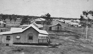
Mount Britton is a rural locality in the Isaac Region, Queensland, Australia. It contains the abandoned gold rush town of Mount Britton in the former Nebo Shire. In the 2021 census, Mount Britton had a population of 4 people.

<span class="mw-page-title-main">Mount Coolon, Queensland</span> Town in Queensland, Australia

Mount Coolon is a rural town and locality in the Whitsunday Region, Queensland, Australia. In the 2016 census, the locality of Mount Coolon had a population of 64 people.

<span class="mw-page-title-main">Springlands, Queensland</span> Suburb of Whitsunday Region, Queensland, Australia

Springlands is a rural locality in the Whitsunday Region, Queensland, Australia.

Yalboroo is a rural town and locality in the Mackay Region, Queensland, Australia. In the 2016 census, the locality of Yalboroo had a population of 170 people.

<span class="mw-page-title-main">Guthalungra, Queensland</span> Town in Queensland, Australia

Guthalungra is a rural town and coastal locality in the Whitsunday Region, Queensland, Australia. In the 2016 census, the locality of Guthalungra had a population of 112 people.

Euthulla is a rural locality in the Maranoa Region, Queensland, Australia. In the 2021 census, Euthulla had a population of 364 people.

<span class="mw-page-title-main">Mount Abundance, Queensland</span> Suburb of Maranoa Region, Queensland, Australia

Mount Abundance is a locality in the Maranoa Region, Queensland, Australia. In the 2021 census, Mount Abundance had a population of 178 people.

Mount Charlton is a rural locality in the Mackay Region, Queensland, Australia. In the 2021 census, Mount Charlton had a population of 151 people.

<span class="mw-page-title-main">Cape Conway, Queensland</span> Suburb of Whitsunday Region, Queensland, Australia

Cape Conway is a coastal locality in the Whitsunday Region, Queensland, Australia. In the 2021 census, Cape Conway had "no people or a very low population".

<span class="mw-page-title-main">Winchester, Queensland</span> Suburb of Isaac Region, Queensland, Australia

Winchester is a rural locality in the Isaac Region, Queensland, Australia. In the 2021 census, Winchester had "no people or a very low population".

Tyrconnel is a rural locality split between the Maranoa Region and the Shire of Murweh, both in Queensland, Australia. In the 2021 census, Tyrconnel had a population of 17 people.

<span class="mw-page-title-main">Eungella Hinterland, Queensland</span> Suburb of Mackay Region, Queensland, Australia

Eungella Hinterland is a rural locality in the Mackay Region, Queensland, Australia. In the 2021 census, Eungella Hinterland had "no people or a very low population".

Minerva is a rural locality in the Central Highlands Region, Queensland, Australia. In the 2021 census, Minerva had a population of 55 people.

<span class="mw-page-title-main">Rewan, Queensland</span> Suburb of Central Highlands Region, Queensland, Australia

Rewan is a rural locality in the Central Highlands Region, Queensland, Australia. In the 2021 census, Rewan had a population of 49 people.

<span class="mw-page-title-main">Gemini Mountains, Queensland</span> Suburb of Isaac Region, Queensland, Australia

Gemini Mountains is a rural locality in the Isaac Region, Queensland, Australia. In the 2021 census, Gemini Mountains had a population of 65 people.

Kemmis is a rural locality in the Isaac Region, Queensland, Australia. In the 2021 census, Kemmis had "no people or a very low population".

<span class="mw-page-title-main">Forestvale, Queensland</span> Suburb of Maranoa Region, Queensland, Australia

Forestvale is a rural locality in the Maranoa Region, Queensland, Australia. In the 2021 census, Forestvale had a population of 47 people.

Mount Howe is a rural locality in the Maranoa Region, Queensland, Australia. In the 2021 census, Mount Howe had a population of 20 people.

<span class="mw-page-title-main">Noorindoo, Queensland</span> Suburb of Maranoa Region, Queensland, Australia

Noorindoo is a rural locality in the Maranoa Region, Queensland, Australia. In the 2021 census, Noorindoo had a population of 71 people.

Mount Bindango is a rural locality in the Maranoa Region, Queensland, Australia. In the 2021 census, Mount Bindango had a population of 26 people.

References

  1. 1 2 3 Australian Bureau of Statistics (28 June 2022). "Mount Moffatt (SAL)". 2021 Census QuickStats. Retrieved 28 February 2023. OOjs UI icon edit-ltr-progressive.svg
  2. 1 2 "Mount Moffatt". Australia Post. Archived from the original on 2 October 2023. Retrieved 10 December 2023.
  3. 1 2 "Mount Moffatt – locality in Maranoa Region (entry 47441)". Queensland Place Names. Queensland Government . Retrieved 2 November 2019.
  4. 1 2 3 4 "Queensland Globe". State of Queensland . Retrieved 10 December 2023.
  5. 1 2 3 4 5 6 7 8 9 10 11 12 13 "Mountain peaks and capes - Queensland". Queensland Open Data. Queensland Government. 12 November 2020. Archived from the original on 25 November 2020. Retrieved 25 November 2020.
  6. "Mount Rugged – mountain in Maranoa Region (entry 29276)". Queensland Place Names. Queensland Government . Retrieved 25 November 2020.
  7. "Mount Campbell – mountain in Maranoa Region (entry 5989)". Queensland Place Names. Queensland Government . Retrieved 25 November 2020.
  8. 1 2 "Mount Moffatt – mountain in Maranoa Region (entry 22426)". Queensland Place Names. Queensland Government . Retrieved 25 November 2020.
  9. "The Observatory – mountain in Maranoa Region (entry 34045)". Queensland Place Names. Queensland Government . Retrieved 25 November 2020.
  10. "Rough Mountain – mountain in Maranoa Region (entry 29147)". Queensland Place Names. Queensland Government . Retrieved 25 November 2020.
  11. "Mount Macleay – mountain in Maranoa Region (entry 20490)". Queensland Place Names. Queensland Government . Retrieved 25 November 2020.
  12. "Mount Judy – mountain in Maranoa Region (entry 17415)". Queensland Place Names. Queensland Government . Retrieved 25 November 2020.
  13. "Mount Misery – mountain in Maranoa Region (entry 22290)". Queensland Place Names. Queensland Government . Retrieved 25 November 2020.
  14. "Mount Clift – mountain in Maranoa Region (entry 7435)". Queensland Place Names. Queensland Government . Retrieved 25 November 2020.
  15. "Mount Ogilby – mountain in Maranoa Region (entry 25238)". Queensland Place Names. Queensland Government . Retrieved 25 November 2020.
  16. "Ogilby Knob – mountain in Maranoa Region (entry 25237)". Queensland Place Names. Queensland Government . Retrieved 25 November 2020.
  17. "Mount Eddystone – mountain in Maranoa Region (entry 11163)". Queensland Place Names. Queensland Government . Retrieved 25 November 2020.
  18. Australian Bureau of Statistics (27 June 2017). "Mount Moffatt (SSC)". 2016 Census QuickStats. Retrieved 20 October 2018. OOjs UI icon edit-ltr-progressive.svg
  19. "Layers: Locality; Schools and school catchments". Queensland Globe. Queensland Government. Archived from the original on 19 December 2017. Retrieved 10 December 2023.