Blackall-Tambo Region

Last updated

Blackall-Tambo Region
Queensland
Blackall-Tambo LGA Qld.png
Location within Queensland
Population1,863 (2018) [1]
 • Density0.061008/km2 (0.15801/sq mi)
Established2008
Area30,537 km2 (11,790.4 sq mi) [1]
MayorAndrew Martin
Council seat Blackall
Region Central West Queensland
State electorate(s) Gregory
Federal division(s) Maranoa
Blackall-Tambo Regional Council.svg
Website Blackall-Tambo Region
LGAs around Blackall-Tambo Region:
Longreach Barcaldine Central Highlands
Longreach Blackall-Tambo Region Murweh
Quilpie Murweh Murweh

The Blackall-Tambo Region is a local government area in Central West Queensland, Australia. Established in 2008, it was preceded by two previous local government areas dating from the 1870s.

Contents

For the financial year 2010/11 it had an approximate operating budget of A$30m. [2]

In June 2018, the Blackall-Tambo Region had a population of 1,863. [1]

History

Kuungkari (also known as Kungkari and Koonkerri) is a language of Western Queensland. The Kuungkari language region includes the landscape within the local government boundaries of Longreach Shire Council and Blackall-Tambo Shire Council. [3]

Prior to the 2008 amalgamation, the Blackall-Tambo Region existed as two distinct local government areas:

The entire Region was originally part of Kargoolnah Division, which was created on 11 November 1879 as one of 74 divisions around Queensland under the Divisional Boards Act 1879. On 20 May 1880, a municipal Borough of Blackall was created to cover the town and its first councillors were elected in July 1880. On 1 January 1881, a new Tambo Division was proclaimed and excised from Kargoolnah.

With the passage of the Local Authorities Act 1902, Kargoolnah became a Shire on 31 March 1903, while Blackall became a Town. The latter was abolished on 7 November 1931 and became Division 3 of the Kargoolnah Shire, which had in the meantime shrunk to include only the Blackall region. On 19 November 1932, after representations to the State Government, Kargoolnah was officially renamed Blackall.

In July 2007, the Local Government Reform Commission released its report and recommended that the two areas amalgamate. Both councils opposed the amalgamation. [4] On 15 March 2008, the two Shires formally ceased to exist, and elections were held on the same day to elect councillors and a mayor to the Regional Council.

Wards

The Region has four divisions, each of whom elects one councillor, and a mayor is directly elected for the entire region.

Mayors

Towns and localities

The Blackall-Tambo Region includes the following settlements:

Amenities

Blackall-Tambo Regional Council operate public libraries at Blackall and Tambo. [9]

Population

The populations given relate to the component entities prior to 2008.

YearPopulation
(Region total)
Population
(Blackall)
Population
(Tambo)
19333,7032,755948
19473,3702,488882
19543,8252,7801,045
19614,4153,2911,124
19664,0043,067937
19713,1562,325831
19762,8282,160668
19812,9852,223762
19862,7742,070704
19912,6612,045616
19962,3991,833566
20012,4501,822628
20062,1391,524615
20161,903

Related Research Articles

<span class="mw-page-title-main">Shire of Mareeba</span> Local government area in Queensland, Australia

The Shire of Mareeba is a local government area at the base of Cape York Peninsula in Far North Queensland, inland from Cairns. The shire, administered from the town of Mareeba, covered an area of 53,491 square kilometres (20,653.0 sq mi), and existed as a local government entity from 1879 until 2008, when it amalgamated with several councils in the Atherton Tableland area to become the Tablelands Region.

<span class="mw-page-title-main">Shire of Barcoo</span> Local government area in Queensland, Australia

The Shire of Barcoo is a local government area in Central West Queensland, Australia. In June 2018, the shire had a population of 267 people.

<span class="mw-page-title-main">Shire of Tambo (Queensland)</span> Local government area in Queensland, Australia

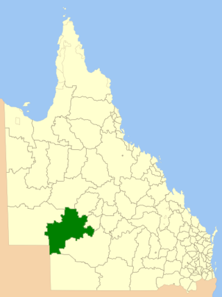
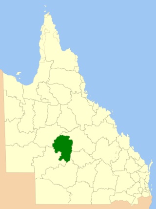
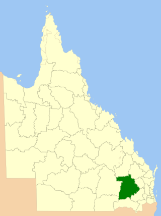
The Shire of Tambo was a local government area located in central Queensland south-east of the town of Blackall. It covered an area of 14,083.8 square kilometres (5,437.8 sq mi), and existed as a local government entity from 1881 until 2008, when it amalgamated with neighbouring Shire of Blackall to form the Blackall-Tambo Region.

<span class="mw-page-title-main">Shire of Blackall</span> Local government area in Queensland, Australia

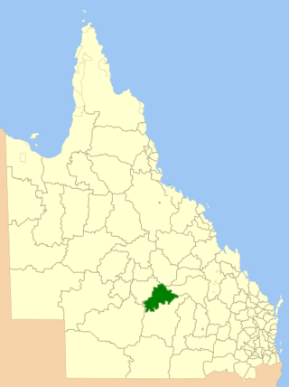
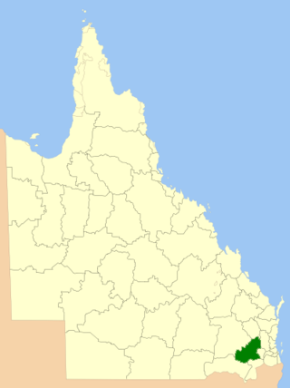
The Shire of Blackall was a local government area located in central Queensland around the town of Blackall. It covered an area of 16,366.8 square kilometres (6,319.3 sq mi), and existed as a local government entity from 1879 until 2008, when it amalgamated with neighbouring Shire of Tambo to form the Blackall-Tambo Region.

<span class="mw-page-title-main">North Burnett Region</span> Local government area in Queensland, Australia

The North Burnett Region is a local government area in Queensland, Australia in the northern catchment of the Burnett River. Established in 2008, it was preceded by several previous local government areas with histories extending back to the early 1900s.

<span class="mw-page-title-main">South Burnett Region</span> Local government area in Queensland, Australia

The South Burnett Region is a local government area in the South Burnett district of Queensland, Australia.

<span class="mw-page-title-main">Maranoa Region</span> Local government area in Queensland, Australia

Maranoa Region is a local government area in South West Queensland, Australia. The town of Roma is the administrative headquarters of the region.

<span class="mw-page-title-main">Barcaldine Region</span> Local government area in Queensland, Australia

The Barcaldine Region is a local government area in Central West Queensland, Australia. Established in 2008, it was preceded by three previous local government areas which had existed for over a century.

<span class="mw-page-title-main">Cassowary Coast Region</span> Local government area in Queensland, Australia

The Cassowary Coast Region is a local government area in the Far North Queensland region of Queensland, Australia, south of Cairns and centred on the towns of Innisfail, Cardwell and Tully. It was created in 2008 from a merger of the Shire of Cardwell and the Shire of Johnstone.

<span class="mw-page-title-main">Tablelands Region</span> Local government area in Queensland, Australia

The Tablelands Region is a local government area in Far North Queensland, Australia inland from the city of Cairns. Established in 2008, it was preceded by four previous local government areas which dated back more than a century. On 1 January 2014, one of those local government areas, the Shire of Mareeba, was re-established independent of the Tablelands Region.

<span class="mw-page-title-main">Longreach Region</span> Local government area in Queensland, Australia

The Longreach Region is a local government area in Central West Queensland, Australia. Established in 2008, it superseded three previous local government areas that had existed for more than a century.

<span class="mw-page-title-main">Bundaberg Region</span> Local government area in Queensland, Australia

The Bundaberg Region is a local government area in the Wide Bay–Burnett region of Queensland, Australia, about 360 kilometres (220 mi) north of Brisbane, the state capital. It is centred on the city of Bundaberg, and also contains a significant rural area surrounding the city. It was created in 2008 from a merger of the City of Bundaberg with the Shires of Burnett, Isis and Kolan.

<span class="mw-page-title-main">Toowoomba Region</span> Local government area in Queensland, Australia

The Toowoomba Region is a local government area located in the Darling Downs part of Queensland, Australia. Established in 2008, it was preceded by several previous local government areas with histories extending back to the early 1900s and beyond.

<span class="mw-page-title-main">Charters Towers Region</span> Local government area in Queensland, Australia

The Charters Towers Region is a local government area in North Queensland, Australia southwest of, and inland from the city of Townsville, based in Charters Towers. Established in 2008, it was preceded by two previous local government areas which dated back to the 1870s.

<span class="mw-page-title-main">Mackay Region</span> Local government area in Queensland, Australia

The Mackay Region is a local government area located in North Queensland, Queensland, Australia. Established in 2008, it was preceded by three previous local government areas with modern histories extending back as far as 1869.

<span class="mw-page-title-main">Southern Downs Region</span> Local government area in Queensland, Australia

The Southern Downs Region is a local government area in the Darling Downs region of Queensland, Australia, along the state's boundary with New South Wales. It was created in 2008 from a merger of the Shire of Warwick and the Shire of Stanthorpe.

<span class="mw-page-title-main">Western Downs Region</span> Local government area in Queensland, Australia

Western Downs Region is a local government area in Queensland, Australia. The Western Downs Regional Council manages an area of 37,937 square kilometres (14,648 sq mi), which is slightly smaller than Switzerland, although with a population of 34,467 in June 2018, it is over 228 times less densely populated.

<span class="mw-page-title-main">Whitsunday Region</span> Local government area in Queensland, Australia

The Whitsunday Region is a local government area located in North Queensland, Australia. Established in 2008, it was preceded by two previous local government areas with a history extending back to the establishment of regional local government in Queensland in 1879.

<span class="mw-page-title-main">Gympie Region</span> Local government area in Queensland, Australia

The Gympie Region is a local government area in the Wide Bay–Burnett region of Queensland, Australia, about 170 kilometres (110 mi) north of Brisbane, the state capital. It is between the Sunshine Coast and Hervey Bay and centred on the town of Gympie. It was created in 2008 from a merger of the Shires of Cooloola and Kilkivan and part of the Shire of Tiaro.

<span class="mw-page-title-main">Cairns Region</span> Local government area of Queensland, Australia

The Cairns Region is a local government area in Far North Queensland, Queensland, Australia, centred on the regional city of Cairns. It was established in 2008 by the amalgamation of the City of Cairns and the Shires of Douglas and Mulgrave. However, following public protest and a referendum in 2013, on 1 January 2014, the Shire of Douglas was de-amalgamated from the Cairns Region and re-established as a separate local government authority.
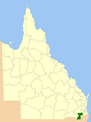
References

  1. 1 2 3 "3218.0 – Regional Population Growth, Australia, 2017-18: Population Estimates by Local Government Area (ASGS 2018), 2017 to 2018". Australian Bureau of Statistics. Australian Bureau of Statistics. 27 March 2019. Retrieved 25 October 2019. Estimated resident population, 30 June 2018.
  2. Blackall-Tambo Regional Council annual report 2011-12 http://www.btrc.qld.gov.au/web/guest/our-finances
  3. CC BY icon-80x15.png This Wikipedia article incorporates CC-BY-4.0 licensed text from: "Queensland Aboriginal and Torres Strait Islander languages map". State Library of Queensland. State Library of Queensland . Retrieved 30 January 2020.
  4. Queensland Local Government Reform Commission (July 2007). Report of the Local Government Reform Commission (PDF). Vol. 2. pp. 37–41. ISBN   978-1-921057-11-3. Archived from the original (PDF) on 17 March 2011. Retrieved 3 June 2010.
  5. Election summary Archived 5 October 2009 at the Wayback Machine (ECQ)
  6. "2012 Blackall-Tambo Regional Council - Mayoral Election - Election Summary". Electoral Commission of Queensland. 28 May 2012. Retrieved 16 March 2017.
  7. "2016 Blackall-Tambo Regional Council - Mayoral Election - Election Summary". Electoral Commission of Queensland. 19 April 2016. Retrieved 16 March 2017.
  8. "2020 Local Government Elections: Saturday, 28 March 2020". Electoral Commission of Queensland. 2020. Archived from the original on 16 June 2020. Retrieved 16 June 2020.
  9. "Blackall-Tambo Regional Council". Public Libraries Connect. State Library of Queensland. 20 September 2016. Archived from the original on 6 February 2018. Retrieved 6 February 2018.

24°39′14″S145°48′49″E / 24.65389°S 145.81361°E / -24.65389; 145.81361