
Blackall is a rural town and locality in the Blackall-Tambo Region, Queensland, Australia. The town is the service centre for the Blackall-Tambo Region. The dominant industry in the area is grazing with over 70 homesteads in the locality. In the 2021 census, the locality of Blackall had a population of 1,365 people.
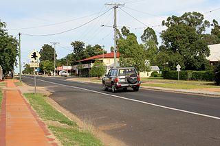
Tambo is a rural town and locality in the Blackall-Tambo Region, Queensland, Australia. Cattle and tourism are the major industries of the town. A number of heritage buildings survive from the earliest days of settlement. In the 2021 census, the population of the locality was 318 people, while the population of the town was 283 people.
The Shire of Tambo was a local government area located in central Queensland south-east of the town of Blackall. It covered an area of 14,083.8 square kilometres (5,437.8 sq mi), and existed as a local government entity from 1881 until 2008, when it amalgamated with neighbouring Shire of Blackall to form the Blackall-Tambo Region.

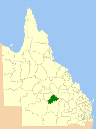
The Blackall-Tambo Region is a local government area in Central West Queensland, Australia. Established in 2008, it was preceded by two previous local government areas dating from the 1870s.

Balmoral Ridge is a rural locality in the Sunshine Coast Region, Queensland, Australia. In the 2021 census, Balmoral Ridge had a population of 302 people.

Witta is a rural town and locality in the Sunshine Coast Region, Queensland, Australia. In the 2021 census, the locality of Witta had a population of 1,296 people.
Scrubby Creek is a rural locality in the Blackall-Tambo Region, Queensland, Australia. In the 2021 census, Scrubby Creek had "no people or a very low population".

Nive is a rural locality in the Shire of Murweh, Queensland, Australia. It is on the boundary between the Shire of Murweh and the Blackall-Tambo Region. In the 2021 census, Nive had a population of 44 people.
Cape Hillsborough is a coastal locality in the Mackay Region, Queensland, Australia. In the 2021 census, Cape Hillsborough had a population of 39 people.
Yandarlo is a locality in the Blackall-Tambo Region, Queensland, Australia. In the 2021 census, Yandarlo had a population of 39 people.
Caldervale is a rural locality in the Blackall-Tambo Region, Queensland, Australia. In the 2021 census, Caldervale had "no people or a very low population".
Trotter Creek is a rural locality in the Rockhampton Region, Queensland, Australia. In the 2021 census, Trotter Creek had a population of 12 people.
Mount Pluto is a rural locality in the Whitsunday Region, Queensland, Australia. In the 2021 census, Mount Pluto had "no people or a very low population".
Mount Julian is a rural locality in the Whitsunday Region, Queensland, Australia. In the 2021 census, Mount Julian had a population of 477 people.
Bayrick is a rural locality in the Blackall-Tambo Region, Queensland, Australia. In the 2021 census, Bayrick had a population of 16 people.
Lumeah is a rural locality in the Blackall-Tambo Region, Queensland, Australia. In the 2021 census, Lumeah had "no people or a very low population".
Lansdowne is a rural locality in the Blackall-Tambo Region, Queensland, Australia. In the 2021 census, Lansdowne had a population of 36 people.
Minnie Downs is a rural locality in the Blackall-Tambo Region, Queensland, Australia. In the 2021 census, Minnie Downs had a population of 12 people.
Macfarlane is a rural locality in the Blackall-Tambo Region, Queensland, Australia. In the 2021 census, Macfarlane had a population of 17 people.
Windeyer is a rural locality in the Blackall-Tambo Region, Queensland, Australia. In the 2021 census, Windeyer had a population of 29 people.
