Shire of Barcoo

Last updated

Shire of Barcoo
Queensland
Barcoo LGA Qld.png
Location within Queensland
Population267 (2018) [1]
 • Density0.004318/km2 (0.011184/sq mi)
Established1887
Area61,830 km2 (23,872.7 sq mi) [1]
MayorSally Elizabeth O'Neil
Council seat Jundah
Region Central West Queensland
State electorate(s) Gregory
Federal division(s) Maranoa
Barcoo shire council logo.svg
Website Shire of Barcoo
LGAs around Shire of Barcoo:
Diamantina Winton Longreach
Diamantina Shire of Barcoo Longreach
Outback Areas (SA) Bulloo Quilpie

The Shire of Barcoo is a local government area in Central West Queensland, Australia. In June 2018, the shire had a population of 267 people. [1]

Contents

It covers an area of 61,830 square kilometres (23,872.7 sq mi), and has existed as a local government entity since 1887. It is named for the Barcoo River which reaches a confluence with the Thomson River in the shire to form Cooper Creek.

The major industry in the shire is beef production and some opal mining. There has been some development of the known oil and gas reserves in the region.

History

Map of Barcoo Division and adjacent local government areas, March 1902 Barcoo Division, March 1902.jpg
Map of Barcoo Division and adjacent local government areas, March 1902

Kuungkari (also known as Kungkari and Koonkerri) is a language of Western Queensland. The Kuungkari language region includes the landscape within the local government boundaries of Longreach Shire Council and Blackall-Tambo Shire Council. [2]

The Barcoo Division was created on 24 December 1887 out of the eastern part of the Diamantina Division, [3] and was subject to the Divisional Boards Act 1887.

In 1927, the council met at Stonehenge. [4]

With the passage of the Local Authorities Act 1902, Barcoo Division became the Shire of Barcoo on 31 March 1903.

It subsequently lost areas when the shires of Isisford (1908) and Quilpie (1930) were incorporated.

Its present mayor, Sally O'Neil, has been in office since 2020.

Towns and localities

The Shire of Barcoo includes the following settlements:

Chairmen and mayors

Population

YearPopulation
1933957
1947835
19541,010
19611,037
1966909
1971734
1976657
1981711
1986566
1991556
1996492
2001576
2006361
2016267

Libraries

The Barcoo Shire Council operates public libraries at Jundah, Stonehenge, and Windorah. [9]

Related Research Articles

<span class="mw-page-title-main">Shire of Burdekin</span> Local government area in Queensland, Australia

The Shire of Burdekin is a local government area located in North Queensland, Australia in the Dry Tropics region. The district is located between Townsville and Bowen in the delta of the Burdekin River.

<span class="mw-page-title-main">Shire of Paroo</span> Local government area in Queensland, Australia

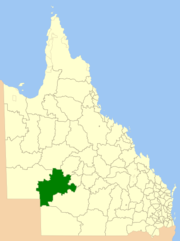
The Shire of Paroo is a local government area in South West Queensland, Australia. The administrative centre is the town of Cunnamulla. The Paroo Shire covers an area of 47,623 square kilometres (18,387 sq mi). In the 2021 census, the Shire had a population of 1,679.

<span class="mw-page-title-main">Shire of Balonne</span> Local government area in Queensland, Australia

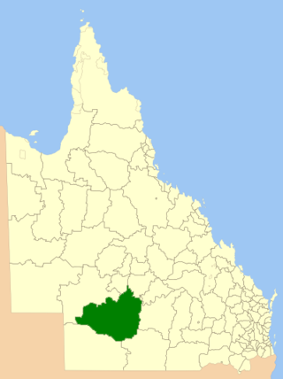
The Shire of Balonne is a local government area in South West Queensland, Australia, over 500 kilometres (310 mi) from the state capital, Brisbane. It covers an area of 31,104 square kilometres (12,009.3 sq mi), and has existed as a local government entity since 1879. It is headquartered in its main town, St George.

<span class="mw-page-title-main">Shire of Bulloo</span> Local government area in Queensland, Australia

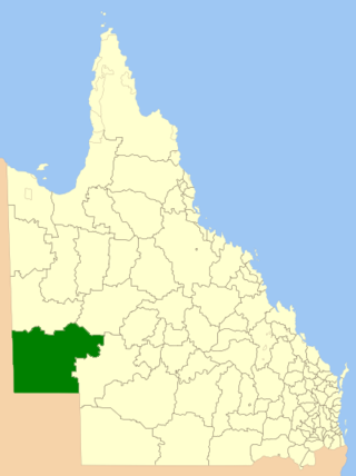
The Shire of Bulloo is a local government area in South West Queensland, Australia.

<span class="mw-page-title-main">Shire of Winton</span> Local government area in Queensland, Australia

The Shire of Winton is a local government area in Central West Queensland, Australia. It covers an area of 53,814 square kilometres (20,777.7 sq mi), and has existed as a local government entity since 1887. Its administrative centre is located in the town of Winton. It is named after Winton, Dorset, England, the birthplace of Robert Allen, the first white settler in the Winton (Queensland) area.

<span class="mw-page-title-main">Shire of Diamantina</span> Local government area in Queensland, Australia

The Shire of Diamantina is a local government area in Central West Queensland, bordering South Australia and the Northern Territory. Its administrative centre is in the town of Bedourie.

<span class="mw-page-title-main">Shire of Boulia</span> Local government area in Queensland, Australia

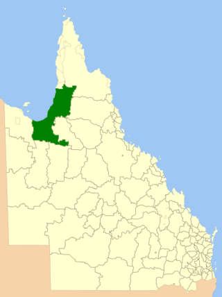
The Shire of Boulia is a local government area in Central West Queensland, bordering the Northern Territory. Its administrative centre is in the town of Boulia.

<span class="mw-page-title-main">Shire of Cloncurry</span> Local government area in Queensland, Australia

The Shire of Cloncurry is a local government area in North West Queensland, Australia. It covers an area of 47,971 square kilometres (18,521.7 sq mi), and has existed as a local government entity since 1884. The major town and administrative centre of the shire is Cloncurry.

<span class="mw-page-title-main">Shire of Mckinlay</span> Local government area in Queensland, Australia

The Shire of Mckinlay is a local government area in outback north-western Queensland, Australia.

<span class="mw-page-title-main">Shire of Richmond</span> Local government area in Queensland, Australia

The Shire of Richmond is a local government area in north western Queensland, Australia.

<span class="mw-page-title-main">Shire of Flinders (Queensland)</span> Local government area in Queensland, Australia

The Shire of Flinders is a local government area in north-western Queensland, Australia.

<span class="mw-page-title-main">Shire of Etheridge</span> Local government area in Queensland, Australia

The Shire of Etheridge is a local government area in Far North Queensland, Australia in what is known as the Savannah Gulf region. Its economy is based on cattle grazing and mining.

<span class="mw-page-title-main">Shire of Croydon</span> Local government area in Queensland, Australia

The Shire of Croydon is a local government area in western Queensland, Australia. The shire, administered from the town of Croydon, covers an area of 29,498 square kilometres (11,389.2 sq mi). The council consists of a mayor plus four councillors, each of whom represents the entire Shire.

<span class="mw-page-title-main">Shire of Carpentaria</span> Local government area in Queensland, Australia

The Shire of Carpentaria is a local government area in Far North Queensland, Australia on the Gulf of Carpentaria, for which it is named.

<span class="mw-page-title-main">Shire of Burke</span> Local government area in Queensland, Australia

The Shire of Burke is a local government area in North West Queensland, Australia. The shire lies on the south coast of the Gulf of Carpentaria and abuts the border with the Northern Territory. It covers an area of 39,864 square kilometres (15,391.6 sq mi), and has existed as a local government entity since 1885. The major town and administrative centre of the shire is Burketown.

<span class="mw-page-title-main">South Burnett Region</span> Local government area in Queensland, Australia

The South Burnett Region is a local government area in the South Burnett district of Queensland, Australia.

<span class="mw-page-title-main">Barcaldine Region</span> Local government area in Queensland, Australia

The Barcaldine Region is a local government area in Central West Queensland, Australia. Established in 2008, it was preceded by three previous local government areas which had existed for over a century.

<span class="mw-page-title-main">Longreach Region</span> Local government area in Queensland, Australia

The Longreach Region is a local government area in Central West Queensland, Australia. Established in 2008, it superseded three previous local government areas that had existed for more than a century.

<span class="mw-page-title-main">Blackall-Tambo Region</span> Local government area in Queensland, Australia

The Blackall-Tambo Region is a local government area in Central West Queensland, Australia. Established in 2008, it was preceded by two previous local government areas dating from the 1870s.

<span class="mw-page-title-main">Jundah, Queensland</span> Town in Queensland, Australia

Jundah is a rural town and locality in the Shire of Barcoo, Queensland, Australia. Jundah is the administrative centre of the Barcoo Shire local government area. In the 2016 census, the locality of Jundah had a population of 106 people.

References

  1. 1 2 3 "3218.0 – Regional Population Growth, Australia, 2017-18: Population Estimates by Local Government Area (ASGS 2018), 2017 to 2018". Australian Bureau of Statistics. 27 March 2019. Retrieved 25 October 2019. Estimated resident population, 30 June 2018.
  2. CC BY icon-80x15.png This Wikipedia article incorporates CC-BY-4.0 licensed text from: "Queensland Aboriginal and Torres Strait Islander languages map". State Library of Queensland. State Library of Queensland . Retrieved 30 January 2020.
  3. "TO-DAY, TUESDAY, JUNE 17. MEETINGS". The Morning Bulletin . Rockhampton, Qld. 17 June 1890. p. 4. Retrieved 24 December 2011.
  4. 1 2 Pugh, Theophilus Parsons (1927). Pugh's Almanac for 1927 . Retrieved 13 June 2014.
  5. "2008 Barcoo Shire – Mayoral Election – Election Summary". Electoral Commission of Queensland. 31 August 2010. Retrieved 16 March 2017.
  6. "2012 Barcoo Shire – Mayoral Election – Election Summary". Electoral Commission of Queensland. 28 May 2012. Retrieved 16 March 2017.
  7. "2016 Barcoo Shire Council – Mayoral Election – Election Summary". Electoral Commission of Queensland. 19 April 2016. Retrieved 16 March 2017.
  8. "2020 Local Government Elections: Saturday, 28 March 2020". Electoral Commission of Queensland. 2020. Retrieved 16 June 2020.[ dead link ]
  9. "Libraries". Barcoo Shire Council . Archived from the original on 31 January 2018. Retrieved 31 January 2018.

Further reading

Coordinates: 25°17′16″S141°58′18″E / 25.28778°S 141.97167°E / -25.28778; 141.97167