Thomson | |
---|---|
![]() Longreach, 1938 | |
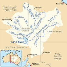
![]() Map of the Lake Eyre Basin showing Thomson River | |
Etymology | Sir Edward Deas Thomson KCMG , CMG |
Location | |
Country | Australia |
State | Queensland |
Region | Central West Queensland, Western Queensland |
City | Longreach |
Physical characteristics | |
Source | Alma Range, Great Dividing Range |
⁃ location | north of Muttaburra |
⁃ elevation | 215 m (705 ft) |
Mouth | confluence with the Barcoo River to form Cooper Creek |
⁃ coordinates | 25°10′2″S142°53′24″E / 25.16722°S 142.89000°E Coordinates: 25°10′2″S142°53′24″E / 25.16722°S 142.89000°E |
⁃ elevation | 130 m (430 ft) |
Length | 350 km (220 mi) |
Basin features | |
River system | Lake Eyre Basin |
Tributaries | |
⁃ right | Landsborough Creek, Darr River |
[1] [2] |
The Thomson River is a perennial river that forms part of the Lake Eyre Basin, situated in the central west and western regions of Queensland, Australia. Much of the course of the river comprises a series of narrow channels synonymous with the Channel Country and the Gailee subregion. [2]
Central West Queensland is a remote region in the Australian state of Queensland which covers 396 650.2 km². The region lies to the north of South West Queensland and south of the Gulf Country.
Western Queensland is split into three regions:
Queensland is the second-largest and third-most populous state in the Commonwealth of Australia. Situated in the north-east of the country, it is bordered by the Northern Territory, South Australia and New South Wales to the west, south-west and south respectively. To the east, Queensland is bordered by the Coral Sea and Pacific Ocean. To its north is the Torres Strait, with Papua New Guinea located less than 200 km across it from the mainland. The state is the world's sixth-largest sub-national entity, with an area of 1,852,642 square kilometres (715,309 sq mi).
The river was named in 1847 by the explorer, Edmund Kennedy, in honour of The Hon. Sir Edward Deas Thomson KCMG , CMG , the Colonial Secretary of New South Wales at the time of discovery. [3] [4]
Edmund Besley Court Kennedy J. P. was an explorer in Australia in the mid nineteenth century. He was the Assistant-Surveyor of New South Wales, working with Sir Thomas Mitchell. Kennedy explored the interior of Queensland and northern New South Wales, including the Thomson River, the Barcoo River, Cooper Creek, and Cape York Peninsula. He died in December 1848 after being speared by Aboriginal Australians in far north Queensland near Cape York.
The prefix The Honourable or The Honorable is an honorific style that is used before the names of certain classes of people.
Sir is a formal English honorific address for men, derived from Sire in the High Middle Ages. Traditionally, as governed by law and custom, Sir is used for men titled knights i.e. of orders of chivalry, and later also to baronets, and other offices. As the female equivalent for knighthood is damehood, the suo jure female equivalent term is typically Dame. The wife of a knight or baronet tends to be addressed Lady, although a few exceptions and interchanges of these uses exist.
Draining the Alma Range, part of the western slopes of the Great Dividing Range, the northernmost headwaters of the river begin as Torrens Creek, inland from Charters Towers. The watercourse becomes the Thomson just north of the town of Muttaburra, where the channels of Landsborough Creek, Towerhill Creek and Cornish Creek meet. Aramac Creek joins the river from the east, south of Muttaburra and Maneroo Creek flows from the west, joining the Thomson south of Longreach. Just to the west of Longreach the river is crossed by the Landsborough Highway.
The Great Dividing Range, or the Eastern Highlands, is Australia's most substantial mountain range and the third longest land-based range in the world. It stretches more than 3,500 kilometres (2,175 mi) from Dauan Island off the northeastern tip of Queensland, running the entire length of the eastern coastline through New South Wales, then into Victoria and turning west, before finally fading into the central plain at the Grampians in western Victoria. The width of the range varies from about 160 km (100 mi) to over 300 km (190 mi). The Greater Blue Mountains Area, Gondwana Rainforests, and Wet Tropics of Queensland World Heritage Areas are located in the range.
Muttaburra is a town and locality in the Barcaldine Region, Queensland, Australia. In the 2016 census, Muttaburra had a population of 88 people.
Longreach is a town and a locality in the Longreach Region, Queensland, Australia. In the 2016 census, Longreach had a population of 2,970 people. It is the administrative centre of the Longreach Regional Council, which was established in 2008 as a merger of the former Longreach, Ilfracombe, and Isisford shires.
The river continues in a south westerly direction, passing the towns of Longreach, Stonehenge and Jundah, before reaching its confluence with the Barcoo River north of Windorah to form Cooper Creek. [5] This is the only place in the world where the confluence of two rivers form a creek.[ citation needed ] From source to mouth, the Thomson is joined by 41 named tributaries over its 350 km (210 miles) course. [1]
Stonehenge is an outback town and locality in the Shire of Barcoo, Queensland, Australia. In the 2016 census, Stonehenge had a population of 44 people.
Jundah is a town and a locality in the Shire of Barcoo, Queensland, Australia. Jundah is the administrative centre of the Barcoo Shire local government area. In the 2016 census, Jundah had a population of 106 people..
In geography, a confluence occurs where two or more flowing bodies of water join together to form a single channel. A confluence can occur in several configurations: at the point where a tributary joins a larger river ; or where two streams meet to become the source of a river of a new name ; or where two separated channels of a river rejoin at the downstream end.
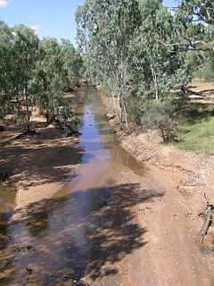
As with all of the rivers in the Lake Eyre Basin, the waters of the Thomson never reach the sea, and instead either evaporate, or, in exceptional flood, empty into Lake Eyre. Floods are relatively common within the catchment because of the summer monsoon rains. [6] Due to the flat nature of the country traversed, the river can then become many kilometres wide. For much of the time, however, the river does not flow, and becomes a line of billabongs, [5] of which fifteen are named. [1]
Lake Eyre, officially known as Kati Thanda–Lake Eyre, contains the lowest natural point in Australia, at approximately 15 m (49 ft) below sea level (AHD), and, on the rare occasions that it fills, is the largest lake in Australia, covering 9,500 km2 (3,668 sq mi). The shallow endorheic lake is the depocentre of the vast Lake Eyre basin and is found in Northern South Australia, some 700 km (435 mi) north of Adelaide.
A billabong is an Australian term for an oxbow lake, an isolated pond left behind after a river changes course. Billabongs are usually formed when the path of a creek or river changes, leaving the former branch with a dead end. As a result of the arid Australian climate in which these "dead rivers" are often found, billabongs fill with water seasonally but can be dry for a greater part of the year.
The area through which the river flows is semi-arid blacksoil plains. The main industries of the area are sheep and beef cattle. [4]
In geography, a plain is a flat, sweeping landmass that generally does not change much in elevation. Plains occur as lowlands along the bottoms of valleys or on the doorsteps of mountains, as coastal plains, and as plateaus or uplands.
Domestic sheep are quadrupedal, ruminant mammals typically kept as livestock. Like most ruminants, sheep are members of the order Artiodactyla, the even-toed ungulates. Although the name sheep applies to many species in the genus Ovis, in everyday usage it almost always refers to Ovis aries. Numbering a little over one billion, domestic sheep are also the most numerous species of sheep. An adult female sheep is referred to as a ewe, an intact male as a ram or occasionally a tup, a castrated male as a wether, and a younger sheep as a lamb.
Beef cattle are cattle raised for meat production. The meat of mature or almost mature cattle is mostly known as beef. In beef production there are three main stages: cow-calf operations, backgrounding, and feedlot operations. The production cycle of the animals start at cow-calf operations; this operation is designed specifically to breed cows for their offspring. From here the calves are backgrounded for a feedlot. Animals grown specifically for the feedlot are known as feeder cattle, the goal of these animals is fattening. Animals not grown for a feedlot are typically female and are commonly known as replacement heifers. While the principal use of beef cattle is meat production, other uses include leather, and beef by-products used in candy, shampoo, cosmetics, insulin and inhalers.
The Barcoo River in western Queensland, Australia rises on the northern slopes of the Warrego Range, flows in a south-westerly direction and unites with the Thomson River to form Cooper Creek. The first European to see the river was Thomas Mitchell in 1846, who named it Victoria River, believing it to be the same river as that named Victoria River by J. C. Wickham in 1839. It was renamed by Edmund Kennedy after a name supplied by local Aborigines.
The Diamantina River is a major river located in Central West Queensland and the far north of South Australia.
The Lake Eyre basin is a drainage basin that covers just under one-sixth of all Australia. It is the largest endorheic basin in Australia and amongst the largest in the world, covering about 1,200,000 square kilometres (463,323 sq mi), including much of inland Queensland, large portions of South Australia and the Northern Territory, and a part of western New South Wales. The basin is also one of the largest, least-developed arid zone basins with a high degree of variability anywhere. It supports about 60,000 people and a large amount of wildlife, and has no major irrigation, diversions or flood-plain developments. Low density grazing is the major land use, occupying 82% of the total land within the basin.
The Cooper Creek is one of the most famous rivers in Australia because it was the site of the death of the explorers Burke and Wills in 1861. It is sometimes known as the Barcoo River from one of its tributaries and is one of three major Queensland river systems that flow into the Lake Eyre basin. The flow of the creek depends on monsoonal rains falling months earlier and many hundreds of kilometres away in eastern Queensland. At 1,300 kilometres (810 mi) in length it is the second longest inland river system in Australia after the Murray-Darling system.
The Stanley River is a perennial river located in the South East region of Queensland, Australia. A major tributary of the Brisbane River, the Stanley River valley extends roughly 35 kilometres (22 mi) westwards from the area south of Maleny, through Woodford to Kilcoy before veering southwards.
The Albert River is a perennial river located in the South East region of Queensland, Australia. Its catchment lies within the Gold Coast and Scenic Rim Region local government areas and covers an area of 782 square kilometres (302 sq mi). The river provides potable water for the town of Beaudesert.
The Barron River is located on the Atherton Tablelands inland from Cairns in northern Queensland, Australia. With its headwaters below Mount Hypipamee, the 165-kilometre (103 mi)-long river with a catchment area of approximately 2,138 square kilometres (825 sq mi) forms through run off from the Mount Hypipamee National Park, flows through Lake Tinaroo, and eventually empties into the Coral Sea near Smithfield.
The Herbert River is a river located in Far North Queensland, Australia. The southernmost of Queensland's wet tropics river systems, it was named in 1864 by George Elphinstone Dalrymple explorer, after Robert George Wyndham Herbert, the first Premier of Queensland.
The Georgina River is the north-westernmost of the three major rivers of the Channel Country in Central West Queensland, that also flows through a portion of the Northern Territory, in central Australia. Part of the Lake Eyre basin, the Georgina flows in extremely wet years into Lake Eyre.
The Belyando River, including the Belyando River , is a river system located in Central Queensland, Australia. At 1,054 kilometres (655 mi) in length and with a catchment area of 35,000 square kilometres (14,000 sq mi), the Belyando River system is one of the longest rivers in Queensland.
The Nogoa River is a river located in Central Queensland, Australia.
The Nive River is a river that is part of the Darling catchment within the Murray–Darling basin, is located in the south west region of Queensland, Australia.
The Galilee Basin is a large inland geological basin in the western Queensland region of Australia. The Galilee Basin is part of a larger Carboniferous to Mid-Triassic basin system that contains the Cooper Basin, situated towards the south-west of the Galilee Basin, and the Bowen Basin to the east. The Galilee Basin covers a total area of approximately 247,000 km2. The basin is underlain by the Carboniferous Drummond Basin and overlain by the Cretaceous – Jurassic Eromanga Basin. The Triassic and younger sediments of the Galilee Basin form the basal sequence of the Great Artesian Basin drainage basin.
The Russell River is a river in Far North Queensland, Australia. The 59-kilometre (37 mi)-long river flows towards the Coral Sea and is located approximately 60 kilometres (37 mi) south of Cairns.
Cornish Creek is a locality in the Barcaldine Region, Queensland, Australia. In the 2016 census, Cornish Creek had a population of 16 people.
The Wilson River, part of the Lake Eyre Basin, is an ephemeral river located in the Channel Country in western Queensland, Australia.
Bangall is a locality in the Barcaldine Region, Queensland, Australia. In the 2016 census, Bangall had a population of 4 people.
Sardine is a locality in the Barcaldine Region, Queensland, Australia. In the 2016 census, Sardine had a population of 5 people.
![]() | Wikimedia Commons has media related to Thomson River (Queensland) . |