Jundah, Queensland

Last updated

Jundah
Queensland
WLA hmns Fiery Opal Opalville Mine.jpg
Fiery Opal from Opalville Mine, Jundah field
Australia Queensland location map.svg
Red pog.svg
Jundah
Coordinates 24°49′57″S143°03′35″E / 24.8325°S 143.0597°E / -24.8325; 143.0597 Coordinates: 24°49′57″S143°03′35″E / 24.8325°S 143.0597°E / -24.8325; 143.0597
Population106 (2016 census) [1]
 • Density0.00810/km2 (0.02098/sq mi)
Postcode(s) 4736
Area13,085.7 km2 (5,052.4 sq mi)
Time zone AEST (UTC+10:00)
Location
LGA(s) Barcoo Shire
County Wolseley
State electorate(s) Gregory
Federal Division(s) Maranoa
Localities around Jundah:
Stonehenge Stonehenge Isisford
Farrars Creek Jundah Adavale
Windorah Windorah Eromanga

Jundah is a town and a locality in the Shire of Barcoo, Queensland, Australia. [2] [3] [1] Jundah is the administrative centre of the Barcoo Shire local government area. In the 2016 census, Jundah had a population of 106 people. [1]

Contents

Geography

The town is located on the Thomson River in Central West Queensland, 1,122 kilometres (697 mi) west of the state capital, Brisbane. [4]

History

Kuungkari (also known as Kungkari and Koonkerri) is a language of Western Queensland. The Kuungkari language region includes the landscape within the local government boundaries of Longreach Shire Council and Blackall-Tambo Shire Council. [5]

The outback town was established in 1883 and given a name meaning "woman" in a local Aboriginal language. [2]

Jundah was first settled by pastoralists Patrick Durack (on Thylungra) and his brother-in-law John Costello (on Kyabra). [6]

In 1873 Jundah was acquired by grazier William Pitt Tozer, who built a homestead on the land. From 1875 to 1880 the Jundah homestead was utilised by the paramilitary Native Police as their main barracks on the lower Thomson River. [7] [8]

Jundah Post Office opened on 26 June 1877 (a receiving office named Jundah Police Barracks had been open from 1876). [9]

Jundah State School opened on 30 April 1900. [10] [11]

Jundah was home to an opal mining industry for around twenty years in the early twentieth century before the industry closed down due to water shortages. [6]

The Jundah Library opened in 2005. [12]

At the 2011 census, Jundah and surrounds had a population of 350. [13]

Heritage listings

Jundah has a number of heritage-listed sites, including:

Economy

Today, the town now supports the surrounding sheep and cattle industry.

Facilities

As well as the Barcoo Shire administration centre, other facilities in the town include a police station, general store, post office agency and a tourist information centre. [6]

The Barcoo Shire Council operate Jundah Library at 11 Dickson Street. [15]

Education

Jundah State School is a government primary (Early Childhood-6) school for boys and girls at 11 Garrick Street ( 24°49′49″S143°03′43″E / 24.8304°S 143.0619°E / -24.8304; 143.0619 (Jundah State School) ). [16] [17] In 2017, the school had an enrolment of 6 students with 2 teachers and 5 non-teaching staff (2 full-time equivalent). [18]

There are no secondary schools in Jundah or nearby. [4] The options would be boarding schools or distance education.

Attractions

Roughly 30 km to the south east of the town is Welford National Park.

Festivals

Each year the town celebrates German-Australian culture by holding "the world's most remote Oktoberfest". [19]

Related Research Articles

Welford National Park Protected area in Queensland, Australia

Welford is a national park in Central West Queensland, Australia, 991 km west of Brisbane founded by Claire Gillman. It is located just to the south east of Jundah. The park was established in 1992 to protect the biodiversity of the mulga lands, mitchell grass and Channel Country ecoregions. The southern border is marked by the Barcoo River.

Windorah Town in Queensland, Australia

Windorah is a town and a locality in the Shire of Barcoo, Queensland, Australia. It is one of only three towns in the Shire of Barcoo in Central West Queensland. In the 2016 census, Windorah had a population of 115 people.

Blackall, Queensland Town in Queensland, Australia

Blackall is a small town and rural locality in the Blackall-Tambo Region in Central West Queensland, Australia. At the 2016 census Blackall had a population of 1,416. It is the service centre for the Blackall-Tambo Region. The dominant industry in the area is grazing.

Isisford, Queensland Town in Queensland, Australia

Isisford is a small town and locality in the Longreach Region in Central West Queensland, Australia.

Thargomindah Town in Queensland, Australia

Thargomindah is a rural town and locality in the Shire of Bulloo, Queensland, Australia. The town of Thargomindah is the administrative centre for the Shire of Bulloo. In the 2016 census, Thargomindah had a population of 270 people. It was founded on Wongkumara and Kalali territory.

Thomson River (Queensland)

The Thomson River is a perennial river that forms part of the Lake Eyre Basin, situated in the central west and western regions of Queensland, Australia. Much of the course of the river comprises a series of narrow channels synonymous with the Channel Country and the Gailee subregion.

Ingham, Queensland Town in Queensland, Australia

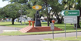
Ingham is a town and locality in the Shire of Hinchinbrook, North Queensland, Australia. It is the administrative centre for the Shire of Hinchinbrook.

Eidsvold, Queensland Town in Queensland, Australia

Eidsvold is a rural town and locality in the North Burnett Region, Queensland, Australia. The town is the self-proclaimed Beef Capital of the Burnett and is a hub for the regional cattle industry. In the 2016 census, Eidsvold had a population of 574 people.

Mitchell, Queensland Town in Queensland, Australia

Mitchell is a town and locality in the Western Downs district of the Maranoa Region, Queensland, Australia. The town services the local area, a cattle and sheep farming district. In the 2016 census, Mitchell had a population of 1031 people.

Monto, Queensland Town in Queensland, Australia

Monto is a rural town and locality in the North Burnett Region, Queensland, Australia. In the 2016 census, Monto had a population of 1,189 people.

Mapoon, Queensland Town in Queensland, Australia

Mapoon is a coastal town in the Aboriginal Shire of Mapoon and a locality split between the Aboriginal Shire of Mapoon and the Shire of Cook in Queensland, Australia.

Forsayth, Queensland Town in Queensland, Australia

Forsayth is a rural town and locality in the Shire of Etheridge, Queensland, Australia. In the 2016 census, Forsayth had a population of 129 people.

Shire of Barcoo Local government area in Queensland, Australia

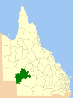
The Shire of Barcoo is a local government area in Central West Queensland, Australia. In June 2018, the shire had a population of 267 people.

Shire of Richmond Local government area in Queensland, Australia

The Shire of Richmond is a local government area in north western Queensland, Australia.

Nebo, Queensland Town in Queensland, Australia

Nebo is a small town and locality in the Isaac Region, Queensland, Australia.

Barcaldine Region Local government area in Queensland, Australia

The Barcaldine Region is a local government area in Central West Queensland, Australia. Established in 2008, it was preceded by three previous local government areas which had existed for over a century.

Stonehenge, Queensland (Barcoo Shire) Town in Queensland, Australia

Stonehenge is an outback town and locality in the Shire of Barcoo, Queensland, Australia. In the 2016 census, Stonehenge had a population of 44 people.

Jambin, Queensland Town in Queensland, Australia

Jambin is a town and locality in the Shire of Banana, Queensland, Australia.

Welford Homestead

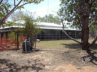
Welford Homestead is a heritage-listed homestead in the Welford National Park, Jundah, Shire of Barcoo, Queensland, Australia. It was added to the Queensland Heritage Register on 21 August 1992.

The Kuungkari are an indigenous Australian people of Queensland. They are to be distinguished from the Kunggari.

References

  1. 1 2 3 Australian Bureau of Statistics (27 June 2017). "Jundah (SSC)". 2016 Census QuickStats. Retrieved 20 October 2018. OOjs UI icon edit-ltr-progressive.svg
  2. 1 2 "Jundah - town in Shire of Barcoo (entry 17485)". Queensland Place Names. Queensland Government . Retrieved 10 June 2019.
  3. "Jundah - locality in Shire of Barcoo (entry 49111)". Queensland Place Names. Queensland Government . Retrieved 10 June 2019.
  4. 1 2 "Queensland Globe". State of Queensland . Retrieved 10 August 2019.
  5. CC-BY-icon-80x15.png This Wikipedia article incorporates CC-BY-4.0 licensed text from: "Queensland Aboriginal and Torres Strait Islander languages map". State Library of Queensland. State Library of Queensland . Retrieved 30 January 2020.
  6. 1 2 3 "JUNDAH". Queensland Health - Work for us - Location Profiles. State of Queensland. 2007. Archived from the original on 17 September 2007. Retrieved 23 September 2007.
  7. "The "Great Run Case."". The Brisbane Courier . XXXII (3, 453). Queensland, Australia. 12 June 1878. p. 3. Retrieved 7 July 2020 via National Library of Australia.
  8. "Country News". The Queenslander . XVII (248). Queensland, Australia. 15 May 1880. p. 615. Retrieved 7 July 2020 via National Library of Australia.
  9. Premier Postal History. "Post Office List". Premier Postal Auctions. Retrieved 10 May 2014.
  10. "Opening and closing dates of Queensland Schools". Queensland Government . Retrieved 18 April 2019.
  11. "Jundah SS" . Retrieved 29 January 2017.
  12. "Public Libraries Statistical Bulletin 2016-17" (PDF). Public Libraries Connect. State Library of Queensland. November 2017. Retrieved 31 January 2017.
  13. Australian Bureau of Statistics (31 October 2012). "Jundah (Windorah) (State Suburb)". 2011 Census QuickStats. Retrieved 7 September 2014. OOjs UI icon edit-ltr-progressive.svg
  14. "Welford Homestead (entry 600023)". Queensland Heritage Register . Queensland Heritage Council. Retrieved 6 July 2013.
  15. "Jundah Library". Public Libraries Connect. State Library of Queensland. November 2017. Retrieved 31 January 2018.
  16. "State and non-state school details". Queensland Government. 9 July 2018. Archived from the original on 21 November 2018. Retrieved 21 November 2018.
  17. "Jundah State School" . Retrieved 21 November 2018.
  18. "ACARA School Profile 2017". Archived from the original on 22 November 2018. Retrieved 22 November 2018.