Tanbar, Queensland

Last updated

Map all coordinates using: OpenStreetMap  
Download coordinates as: KML
Tanbar
Queensland
Turn-off to Haddon Corner, 2019.jpg
Turn-off from Arrabury Road to Haddon Corner, 2019
Australia Queensland location map.svg
Red pog.svg
Tanbar
Coordinates 26°10′15″S141°32′02″E / 26.1708°S 141.5338°E / -26.1708; 141.5338 (Tanbar (centre of locality)) Coordinates: 26°10′15″S141°32′02″E / 26.1708°S 141.5338°E / -26.1708; 141.5338 (Tanbar (centre of locality))
Population3 (2016 census) [1]
 • Density0.00026/km2 (0.00068/sq mi)
Postcode(s) 4481
Area11,465.6 km2 (4,426.9 sq mi)
Time zone AEST (UTC+10:00)
Location
LGA(s) Shire of Barcoo
State electorate(s) Gregory
Federal division(s) Maranoa
Suburbs around Tanbar:
Birdsville Farrars Creek Windorah
South Australia Tanbar Eromanga
South Australia Durham Durham

Tanbar is an outback locality in the Shire of Barcoo, Queensland, Australia. [2] It is on the corner of Queensland's southern and western border with South Australia. In the 2016 census Tanbar had a population of 3 people. [1]

Contents

Geography

Haddon Corner is the point of Queensland's southern and western border with South Australia ( 26°00′00″S141°00′00″E / 26.0000°S 141.0000°E / -26.0000; 141.0000 (Haddon Corner) ). [3] It is in the south-west of the locality. [4]

Lake Yamma Yamma (also known as Lake Mackillop) is in the centre of the locality ( 26°20′00″S141°25′00″E / 26.3333°S 141.4166°E / -26.3333; 141.4166 (Lake Yamma Yamma) ). [5] It is 736 square kilometres (284 sq mi) and is ephemeral, [4] holding water only when Cooper Creek floods. It rarely fills (about every 25 to 30 years). It is Queensland's largest ephemeral lake. [6]

The Birdsville Developmental Road enters the locality from the north (Farrars Creek), passes through the north of the locality, and exits to the north-west (Birdsville). Arrabury Road branches off from the Birdsville Developmental Road shortly after it enters the locality and then proceeds south-west and then south into Durham (remaining west of Lake Yamma Yamma). [4]

The land use is grazing on native vegetation. [4]

History

The name Haddon Corner is derived from Haddon Downs, the pastoral property in the corner on the South Australian side. It was established in 1877 by pastoralists William and John Howie. [3]

In the 2016 census Tanbar had a population of 3 people. [1]

Heritage listings

Heritage-listed survey marker at Haddon Corner, 2019 Survey marker on post, Haddon Corner, 2019.jpg
Heritage-listed survey marker at Haddon Corner, 2019

Heritage-listed sites in Tanbar include:

Economy

There are a number of homesteads in the locality, including: [8]

Education

There are no schools in Tanbar and none nearby. [4] Distance education and boarding schools are the options.

Transport

There are a number of airstrips in the locality, including:

Related Research Articles

Cooper Creek River in Queensland, South Australia

The Cooper Creek is one of the most famous rivers in Australia because it was the site of the death of the explorers Burke and Wills in 1861. It is sometimes known as the Barcoo River from one of its tributaries and is one of three major Queensland river systems that flow into the Lake Eyre basin. The flow of the creek depends on monsoonal rains falling months earlier and many hundreds of kilometres away in eastern Queensland. It is 1,300 kilometres (810 mi) in length.

Camooweal Town in Queensland, Australia

Camooweal is an outback town and locality in the City of Mount Isa, Queensland, Australia. The locality is on the Queensland border with the Northern Territory. In the 2016 census, the locality of Camooweal had a population of 208 people.

Channel Country Bioegion in Australia

The Channel Country is a region of outback Australia mostly in the state of Queensland but also in parts of South Australia, Northern Territory and New South Wales. The name comes from the numerous intertwined rivulets that cross the region, which cover 150,000 km². The Channel Country is over the Cooper and Eromanga geological basins and the Lake Eyre Basin drainage basin. Further to the east is the less arid Maranoa district.

Cameron Corner, Queensland Suburb of Bulloo Shire, Queensland, Australia

Cameron Corner is an outback locality in the Shire of Bulloo, Queensland, Australia. In the 2016 census, Cameron Corner had a population of 5 people. It borders New South Wales to the south and South Australia to the west.

Haddon Corner Historic site in Queensland, Australia

Haddon Corner is a heritage-listed site in Tanbar, Shire of Barcoo, Queensland, Australia. It is in outback Channel Country at South-West Queensland, on the border corner with South Australia. It was added to the Queensland Heritage Register on 9 November 2012.

Shire of Barcoo Local government area in Queensland, Australia

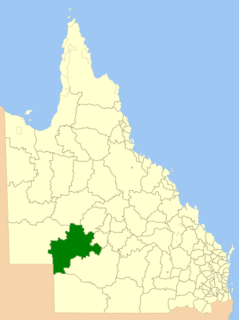
The Shire of Barcoo is a local government area in Central West Queensland, Australia. In June 2018, the shire had a population of 267 people.

Central West Queensland Region in Queensland, Australia

Central West Queensland is a remote region in the Australian state of Queensland which covers 396 650.2 km2. The region lies to the north of South West Queensland and south of the Gulf Country. It has a population of approximately 12,387 people.

Stamford, Queensland Town in Queensland, Australia

Stamford is a rural town and locality in the Shire of Flinders, Queensland, Australia. In the 2016 census, the locality of Stamford had a population of 43 people.

For the former Cattle station in the Kimberley region of Western Australia, see Marion Downs Sanctuary

Pandie Pandie Station, most commonly known as Pandie Pandie, also often spelled as Pandi Pandi or Pandy Pandy, is a pastoral lease that operates as a cattle station in north east South Australia. It lies on the eastern edge of Karanguru territory.

Durrie Station

Durrie Station most commonly referred to as Durrie is a pastoral lease that operates as a cattle station in Queensland.

Morney Plains Station, most commonly referred to as Morney Plains, is a pastoral lease that operates as a cattle station in south west Queensland.

Durham, Queensland Suburb of Bulloo Shire, Queensland, Australia

Durham is a rural locality in the Shire of Bulloo, Queensland, Australia. In the 2016 census Durham had a population of 36 people.

Mulka Station is a pastoral lease that operates as a cattle station in the far north of South Australia. The land occupying the extent of the Mulka Station pastoral lease was gazetted as a locality by the Government of South Australia on 26 April 2013 under the name "Mulka".

North Bungunya is a rural locality in the Goondiwindi Region, Queensland, Australia. In the 2016 census North Bungunya had a population of 39 people.

Strathmore is a locality split between the Shire of Mareeba and the Shire of Etheridge, in Queensland, Australia. In the 2016 census Strathmore had a population of 12 people.

Farrars Creek is a rural locality in the Shire of Barcoo, Queensland, Australia. In the 2016 census, Farrars Creek had a population of 0 people.

Humboldt is a rural locality in the Central Highlands Region, Queensland, Australia. In the 2016 census, Humboldt had a population of 13 people.

Taldora, Queensland Suburb of Shire of Mckinlay, Queensland, Australia

Taldora is an outback locality in the Shire of Mckinlay, Queensland, Australia. In the 2016 census Taldora had a population of 37 people.

Barkly is an outback locality in the City of Mount Isa, Queensland, Australia. The locality is on the Queensland border with Northern Territory. In the 2016 census Barkly had a population of 28 people.

References

  1. 1 2 3 Australian Bureau of Statistics (27 June 2017). "Tanbar (SSC)". 2016 Census QuickStats. Retrieved 20 October 2018. OOjs UI icon edit-ltr-progressive.svg
  2. "Tanbar – locality in Shire of Barcoo (entry 50026)". Queensland Place Names. Queensland Government . Retrieved 26 December 2020.
  3. 1 2 "Haddon Corner – corner in Shire of Barcoo (entry 15173)". Queensland Place Names. Queensland Government . Retrieved 26 December 2020.
  4. 1 2 3 4 5 "Queensland Globe". State of Queensland . Retrieved 15 March 2021.
  5. "Lake Yamma Yamma – lake in Shire of Barcoo (entry 38402)". Queensland Place Names. Queensland Government . Retrieved 26 December 2020.
  6. "BirdLife Data Zone". BirdLife International . Archived from the original on 25 August 2017. Retrieved 16 March 2021.
  7. "Haddon Corner (entry 602807)". Queensland Heritage Register . Queensland Heritage Council. Retrieved 1 August 2014.
  8. "Homesteads - Queensland". Queensland Open Data. Queensland Government. 18 November 2020. Archived from the original on 24 November 2020. Retrieved 24 November 2020.
  9. 1 2 3 4 "Heliports and landing grounds - Queensland". Queensland Open Data. Queensland Government. 22 October 2020. Archived from the original on 16 November 2020. Retrieved 3 November 2020.

Commons-logo.svg Media related to Tanbar, Queensland at Wikimedia Commons