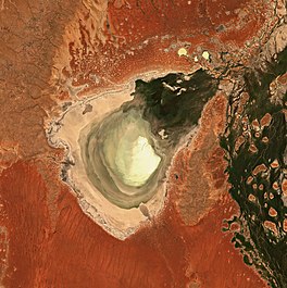
Lake Eyre, officially known as Kati Thanda–Lake Eyre, is an endorheic lake in the east-central part of the Far North region of South Australia, some 700 km (435 mi) north of Adelaide. The shallow lake is the depocentre of the vast endorheic Lake Eyre basin, and contains the lowest natural point in Australia, at approximately 15 m (49 ft) below sea level. On the rare occasions that it fills completely, it is the largest lake in Australia, covering an area of up to 9,500 km2 (3,668 sq mi). When the lake is full, it has the same salinity as seawater, but becomes hypersaline as the lake dries up and the water evaporates.

The Cooper Creek is a river in the Australian states of Queensland and South Australia. It was the site of the death of the explorers Burke and Wills in 1861. It is sometimes known as the Barcoo River from one of its tributaries and is one of three major Queensland river systems that flow into the Lake Eyre basin. The flow of the creek depends on monsoonal rains falling months earlier and many hundreds of kilometres away in eastern Queensland. It is 1,300 kilometres (810 mi) in length.

The Macquarie Marshes comprise the wetlands associated with the floodplains of the Macquarie River and its tributaries, in northern New South Wales, Australia. The Macquarie River and the marshes eventually drain into the Darling River. The marshes are important as a breeding site for waterbirds, especially in the aftermath of major floods.

Lake Argyle is Western Australia's largest and Australia's second largest freshwater man-made reservoir by volume. The reservoir is part of the Ord River Irrigation Scheme and is located near the East Kimberley town of Kununurra. The lake flooded large parts of the Shire of Wyndham-East Kimberley on the Kimberley Plateau about 80 kilometres (50 mi) inland from the Joseph Bonaparte Gulf, close to the border with the Northern Territory.
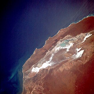
Lake Macleod is a marine salt lake in the Gascoyne region of Western Australia, 30 kilometres (19 mi) north of the port and regional centre of Carnarvon.

The Bulloo RiverBUUL-oo is an isolated drainage system in western Queensland, central Australia. Its floodplain, which extends into northern New South Wales, is an important area for waterbirds when inundated. It comprises most of the Bulloo-Bancannia drainage basin.

Reedy Lake, historically also known as Lake Reedy, is a shallow 5.5-square-kilometre (2.1 sq mi) intermittent freshwater lake or swamp on the lower reaches of the Barwon River, on the Bellarine Peninsula southeast of Geelong in the Australian state of Victoria.

The Goyder Lagoon is a large ephemeral swamp in the Australian state of South Australia in the state's Far North region. The lake is part of the Diamantina River floodplain, lying beside the Birdsville Track close to the state border with Queensland.
The Western District Lakes of Victoria, in the Western District of Victoria, south-eastern Australia, were recognised on 15 December 1982 as wetlands of international importance by listing under the Ramsar Convention, as Ramsar site no.268.
The Lake Machattie Area is a 909 km2 tract of land comprising Lakes Machattie, Mipia and Koolivoo, with the surrounding Georgina River and Eyre Creek floodplains, in the arid Channel Country of western Queensland, Australia. The area is important as a breeding site for waterbirds.

The Lake Sylvester System comprises a system of ephemeral lakes on the Barkly Tableland of the Northern Territory of Australia about 180 km north-east of Tennant Creek.

Lake Woods is an ephemeral freshwater lake in the Northern Territory of Australia. It lies on Newcastle Creek close to the small town of Elliott on the Stuart Highway, about halfway between Darwin and Alice Springs. It is important as a breeding site for waterbirds.

The Lakes Muncoonie, Mumbleberry and Torquinie Important Bird Area is a 2013 km2 tract of land in the Channel Country of western Queensland, Australia.

The Murray-Sunset, Hattah and Annuello Important Bird Area comprises 7004 km2 of mallee habitat in the Mallee region of north-western Victoria, Australia.

The Natimuk-Douglas Wetlands comprise a chain of freshwater, brackish and saline wetlands in the semi-arid Wimmera region of western Victoria. Australia. They are important for waterbirds.
The Paroo Floodplain and Currawinya Important Bird Area is a 7,874 km2 (3,040 sq mi) site comprising the floodplain and the associated wetlands of the Paroo River in north-western New South Wales and south-western Queensland, Australia. It includes extensive areas of the Paroo-Darling and Currawinya National Parks, both of which are listed under the Ramsar Convention as wetland sites of international importance, as well as of the Nocoleche Nature Reserve.

The Strzelecki Desert Lakes Important Bird Area is an Important Bird Area (IBA) in the Australian state of South Australia which consists of a series of ephemeral waterbodies in the arid Strzelecki Desert in the state's Far North region. It is considered to be important for waterbirds when its constituent lakes hold water in the aftermath of floods.

The Tarrabool Lake – Eva Downs Swamp System is an ephemeral wetland complex lying on the west of the Barkly Tableland region in the Northern Territory of Australia. It is listed on the DIWA wetland directory.
The Cooper Floodplain below Windorah comprises a 1741 km2 tract of floodplain of the Cooper Creek river system, below the town of Windorah, in the Channel Country of western Queensland, Australia. When inundated it is an important breeding site for large numbers of waterbirds.

Thunder Creek is a river in the Canadian province of Saskatchewan. The watershed of Thunder Creek is within the semi-arid Palliser's Triangle in south-central Saskatchewan. It begins at small, man-made reservoir near Lake Diefenbaker and flows in a south-easterly direction towards the city of Moose Jaw and the Moose Jaw River. The Moose Jaw River is a major tributary of the Qu'Appelle River For most of its course, Thunder Creek follows a valley called the Thunder Creek meltwater channel that was formed over 10,000 years ago near the end of the last ice age.