Herbert River

Last updated

Herbert
Blencoe falls.jpg
Blencoe Creek flowing over Blencoe Falls into the Herbert River gorge, 2006
Australia Queensland relief location map.jpg
Red pog.svg
Location of Herbert River river mouth in Queensland
Etymology Robert Herbert [1]
Location
Country Australia
State Queensland
Region Far North Queensland, Wet Tropics of Queensland
City Ingham
Physical characteristics
Source Atherton Tableland, Great Dividing Range
Source confluenceMillstream and Wild River
  coordinates 17°41′50″S145°15′49″E / 17.69722°S 145.26361°E / -17.69722; 145.26361
  elevation642 m (2,106 ft)
Mouth Coral Sea
  location
Hinchinbrook Channel
  coordinates
18°32′16″S146°17′21″E / 18.53778°S 146.28917°E / -18.53778; 146.28917
  elevation
0 m (0 ft)
Length288 km (179 mi)
Basin size10,130 km2 (3,910 sq mi) [2]
Discharge 
  locationNear mouth
  average4,330,000 ML/a (137 m3/s) [2]
Basin features
Tributaries 
  leftBlunder Creek, Sunday Creek (Queensland), Cameron Creek (Queensland), Blencoe Creek, Smoko Creek, Yamanie Creek, Gowrie Creek, Elphinstone Creek
  rightBattle Creek (Queensland), Nettle Creek (Queensland), Nanyeta (Return) Creek, Rudd Creek, Flaggy Creek, Stony Creek (Queensland), Stone River
Waterfalls Herbert River Falls, Blencoe Falls, Millstream Falls
[3]

The Herbert River is a river in Far North Queensland, Australia. The southernmost of Queensland's wet tropics river systems, it was named in 1864 by George Elphinstone Dalrymple explorer, after Robert George Wyndham Herbert, the first Premier of Queensland. [1]

Contents

Location and features

With its headwaters forming at an elevation of 1,070 metres (3,510 ft) on the Atherton Tableland, part of the Great Dividing Range west of Herberton and north of Ravenshoe, the Herbert River is formed by the confluence of the Millstream and the Wild River. The Herbert River flows in a generally southeastern direction through the Lumholtz National Park joined by fifteen tributaries including the Stone River and flowing past the town of Ingham. The Herbert River reaches its mouth where it enters the Coral Sea near Lucinda, at the southern end of the Hinchinbrook Channel, 130 kilometres (81 mi) north of Townsville. The river descends 642 metres (2,106 ft) over its 288-kilometre (179 mi) course. [3]

The Herbert River tributaries include the Blunder, Sunday and Cameron Creeks, which all rise in the Cardwell Range and drain the northern portion of the river's catchment area, upstream of the Herbert River Falls. Further south the catchment is drained by the Nanyeta (Return) and Rudd Creeks, which flow out of the Great Dividing Range west of Mount Garnet and from the Forty Mile Scrub area. In total, the river has a catchment of 10,130 square kilometres (3,910 sq mi). [4]

The Wallaman Falls on Stony Creek, another tributary of the Herbert, are Australia's tallest single-drop waterfall. [5] Other waterfalls on the river include Herbert River Falls, Blencoe Falls and Millstream Falls.

Heavy rainfall causes the river level and speed of flow to rise very quickly, especially in the lower flood plain areas around Ingham where rainfall of up to 600 millimetres (24 in) over a few days may occur during peak wet season. Floodwater up to depths of 3 metres (9.8 ft) above ground level occurs in low parts of the town, requiring the evacuation of residents and their property from low-lying areas. [6] The river experienced significant flooding during the 2010–11 Queensland floods.

People and land use

Warrgamay (also known as Waragamai, Wargamay, Wargamaygan, Biyay, and Warakamai) is an Australian Aboriginal language in North Queensland. The language region includes the Herbert River area, Ingham, Hawkins Creek, Long Pocket, Herbert Vale, Niagara Vale, Yamanic Creek, Herbert Gorge, Cardwell, Hinchinbrook Island and the adjacent mainland. [7]

Warungu (also known as Warrungu, Warrongo, and Waroongoo.) is an Australian Aboriginal language in North Queensland. The language region includes areas from the Upper Herbert River to Mount Garnet. [8]

The catchment area holds a population of about 18,000, 75% of whom dwell in the lower flood plain area.[ citation needed ]

The river's upper region is used mainly for cattle grazing, while the lower Herbert River floodplain is given over to sugar cane production. [9] The middle reaches of the catchment include National Parks, State Forests and sections of the Wet Tropics World Heritage Area.

Parts of the river, especially the Herbert River Gorge stretch, are used for kayaking and white water rafting. The Herbert River is one of Australia's two finest extended whitewater journeys, the other the Franklin River in Tasmania. [10]

The second season of the U.S. reality television series, Survivor , was filmed on the "Goshen" cattle station in the upper Herbert River region, near the Blencoe Falls and Herbert River Gorge.

The Herbert, together with the Tully and the Burdekin rivers, were part of the proposed Bradfield Scheme to divert the upper reaches of the three rivers west of the Great Dividing Range and into the Thomson River designed to irrigate and drought-proof much of the western Queensland interior, as well as large areas of South Australia. The Scheme was proposed in 1938 and abandoned in 1947. [11] [12] [13]

See also

Related Research Articles

<span class="mw-page-title-main">Barron Gorge National Park</span> Protected area in Queensland, Australia

Barron Gorge National Park is a protected area in the Cairns Region, Queensland, Australia. It is predominantly within the locality of Barron Gorge.

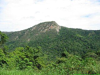
Girringun National Park is a national park in Queensland, Australia, approximately 50 kilometres (31 mi) southwest of Ingham, 110 kilometres (68 mi) north of Townsville and 1,290 kilometres (800 mi) northwest of Brisbane. The park is one of the Wet Tropics World Heritage Area series of national parks, and is a gazetted World Heritage Site.

<span class="mw-page-title-main">Burdekin River</span> River in Queensland, Australia

The Burdekin River is a river in North and Far North Queensland, Australia. The river rises on the northern slopes of Boulder Mountain at Valley of Lagoons, part of the western slope of the Seaview Range, and flows into the Coral Sea at Upstart Bay over 200 kilometres (124 mi) to the southeast of the source, with a catchment area of approximately 130,000 square kilometres (50,000 sq mi). The Burdekin River is Australia's largest river by (peak) discharge volume.

<span class="mw-page-title-main">Wallaman Falls</span> Waterfall on Stony Creek in Queensland, Australia

The Wallaman Falls, a cascade and horsetail waterfall on the Stony Creek, is located in the UNESCO World Heritage–listed Wet Tropics in the locality of Wallaman, Shire of Hinchinbrook in the northern region of Queensland, Australia. The waterfall is notable for its main drop of 268 metres (879 ft), which makes it the country's tallest single-drop waterfall. The pool at the bottom of the waterfall is 20 metres (66 ft) deep. An estimated 100,000 people visit the waterfall annually.

<span class="mw-page-title-main">Hinchinbrook Island</span>

Hinchinbrook Island is an island in the Cassowary Coast Region, Queensland, Australia. It lies east of Cardwell and north of Lucinda, separated from the north-eastern coast of Queensland by the narrow Hinchinbrook Channel. Hinchinbrook Island is part of the Great Barrier Reef Marine Park and wholly protected within the Hinchinbrook Island National Park, except for a small and abandoned resort. It is the largest island on the Great Barrier Reef. It is also the largest island national park in Australia.

<span class="mw-page-title-main">Cardwell, Queensland</span> Town in Queensland, Australia

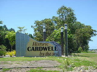
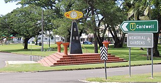
Cardwell is a coastal town and rural locality in the Cassowary Coast Region, Queensland, Australia. In the 2016 census, the locality of Cardwell had a population of 1,309 people.

<span class="mw-page-title-main">Ingham, Queensland</span> Town in Queensland, Australia

Ingham is a rural town and locality in the Shire of Hinchinbrook, Queensland, Australia. It is named after William Bairstow Ingham and is the administrative centre for the Shire of Hinchinbrook.

<span class="mw-page-title-main">Flinders River</span> River in Queensland, Australia

The Flinders River is the longest river in Queensland, Australia, at approximately 1,004 kilometres (624 mi). It was named in honour of the explorer Matthew Flinders. The catchment is sparsely populated and mostly undeveloped. The Flinders rises on the western slopes of the Great Dividing Range in North West Queensland and flows generally north-west through the Gulf Country, across a large, flat clay pan, before entering the Gulf of Carpentaria.

<span class="mw-page-title-main">North Queensland</span> Region in Queensland, Australia

North Queensland or the Northern Region is the northern part of the Australian state of Queensland that lies just south of Far North Queensland. Queensland is a massive state, larger than many countries, and its tropical northern part has been historically remote and undeveloped, resulting in a distinctive regional character and identity.

<span class="mw-page-title-main">Murray Falls</span> Waterfall in Far North Queensland, Australia

The Murray Falls, a cascade waterfall on the Murray River, is located in the UNESCO World Heritage–listed Wet Tropics in Murray Upper, Cassowary Coast Region in the Far North region of Queensland, Australia.

The Herbert River Falls is a plunge waterfall on the Herbert River that is located in the UNESCO World Heritage–listed Wet Tropics in the Far North region of Queensland, Australia.

<span class="mw-page-title-main">Blencoe Falls</span> Waterfall in Far North Queensland

The Blencoe Falls is a segmented waterfall on the Blencoe Creek, located in Kirrama, Tablelands Region, in Far North Queensland, Australia.

<span class="mw-page-title-main">Tully River</span> River in Queensland, Australia

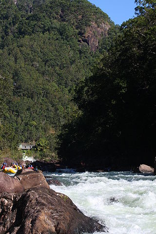
The Tully River is a river in Far North Queensland, Australia.

<span class="mw-page-title-main">Johnstone River</span> River in Queensland, Australia

The Johnstone River, comprising the North Johnstone River and the South Johnstone River, is a river system in Far North and North Queensland, Australia.

<span class="mw-page-title-main">Geography of Queensland</span> Geography of Queensland in north-east of Australia

The geography of Queensland in the north-east of Australia, is varied. It includes tropical islands, sandy beaches, flat river plains that flood after monsoon rains, tracts of rough, elevated terrain, dry deserts, rich agricultural belts and densely populated urban areas.

The Seaview Range, part of the Great Dividing Range, is a mountain range located west of Ingham in North Queensland, Australia. Much of the range is covered by rainforest and parts of it are protected in the Girringun National Park and the Wet Tropics of Queensland world heritage area.

Warrgamay is an extinct Australian Aboriginal language of northeast Queensland. It was closely related to Dyirbal.

The Warruŋu, also known as the Warungu/Warrongo, were an Indigenous Australian people of the northern Queensland rainforest areas south of Cairns.

<span class="mw-page-title-main">Murray Upper, Queensland</span> Suburb of Cassowary Coast Region, Queensland, Australia

Murray Upper is a rural locality in the Cassowary Coast Region, Queensland, Australia. In the 2016 census Murray Upper had a population of 266 people.

<span class="mw-page-title-main">Hawkins Creek, Queensland</span> Suburb of Shire of Hinchinbrook, Queensland, Australia

Hawkins Creek is a rural locality in the Shire of Hinchinbrook, Queensland, Australia. In the 2016 census, Hawkins Creek had a population of 216 people.

References

  1. 1 2 "Herbert River Place name details (entry 15762)". Queensland Place Names. Queensland Government . Retrieved 13 September 2015.
  2. 1 2 "Basin & Surface Water Management Area: Herbert River". Archived from the original on 4 October 2009.
  3. 1 2 "Map of Herbert River". Bonzle Digital Atlas of Australia. Retrieved 25 July 2015.
  4. "Water resources - Overview - Queensland - Basin & Surface Water Management Area: Herbert River". Australian Natural Resources Atlas. Department of the Environment, Water, Heritage and the Arts. Archived from the original on 22 June 2009. Retrieved 2 May 2009.
  5. Lloyd, Graham (6 April 2013). "Wild Australia: Legends of the Wallaman falls". The Australian . Retrieved 1 December 2013.
  6. "Flood warning system for the Herbert River". Bureau of Meteorology . Australian Government. June 2015. Retrieved 29 October 2015.
  7. CC BY icon-80x15.png This Wikipedia article incorporates CC-BY-4.0 licensed text from: "Warrgamay". Queensland Aboriginal and Torres Strait Islander languages map. State Library of Queensland . Retrieved 5 February 2020.
  8. CC BY icon-80x15.png This Wikipedia article incorporates CC-BY-4.0 licensed text from: "Warungu". Queensland Aboriginal and Torres Strait Islander languages map. State Library of Queensland . Retrieved 5 February 2020.
  9. Cane Trains in the Herbert River Valley Stocks, I.L. Australian Railway Historical Society Bulletin, December, 1972 pp242-264
  10. Newton, Matthew (21 October 2014). "Kayaking the Herbert River FNQ". Australian Geographic . Retrieved 29 October 2015.
  11. "Augmenting Queensland's Inland Water Resources by J.J.C. Bradfield". The Courier-Mail . Brisbane: National Library of Australia. 1 October 1938. p. 6. Retrieved 7 December 2010.
  12. ""Suggested Answer" to question-without-notice of the Prime Minister, explaining the impracticality of the Bradfield Scheme" (PDF). National Archives of Australia. 14 November 1946.
  13. Spearritt, Peter (1979). Bradfield, John Job Crew (1867 - 1943). pp. 381–383.{{cite book}}: |work= ignored (help)