Normanby River

Last updated

Normanby
East Normanby, West Normanby, East Normanby North Branch, East Normanby South Branch, Granite Normanby
Normanby-river.JPG
Australia Queensland relief location map.jpg
Red pog.svg
Location of Normanby River river mouth in Queensland
EtymologyIn honour of George Phipps, 2nd Marquess of Normanby [1]
Location
Country Australia
State Queensland
Region Far North Queensland, Cape York Peninsula, Wet Tropics of Queensland
Physical characteristics
Source Great Dividing Range
  locationwest of Wujal Wujal
  coordinates 15°55′S145°12′E / 15.917°S 145.200°E / -15.917; 145.200
Source confluenceEast and West Normanby Rivers
  coordinates 15°39′39″S144°56′17″E / 15.66083°S 144.93806°E / -15.66083; 144.93806
  elevation125 m (410 ft)
Mouth Princess Charlotte Bay
  location
Rinyirru National Park
  coordinates
14°23′47″S144°08′37″E / 14.39639°S 144.14361°E / -14.39639; 144.14361
  elevation
0 m (0 ft)
Length350 km (220 mi)
Basin size24,408 km2 (9,424 sq mi)
Discharge 
  location Princess Charlotte Bay
  average390 m3/s (14,000 cu ft/s)
Basin features
Tributaries 
  leftBanana Creek (Queensland), Beardmore Creek, Cabbage Tree (Welcome) Creek, Laura River, Kennedy River
  rightNigger Creek (Queensland), Surrender Creek, Trapp Creek, Bridge Creek (Queensland), Jack River (Queensland), House Creek (Queensland)
National park Rinyirru National Park
[2] [3] [4] [5] [6] [7]

The Normanby River, comprising the East Normanby River, the West Normanby River, the East Normanby River North Branch, the East Normanby River South Branch and the Granite Normanby River, is a river system in Far North Queensland, Australia.

Contents

This area is also referred to as the Norman-Laura Catchment and Norman Sub-Basin. [8]

Location and features

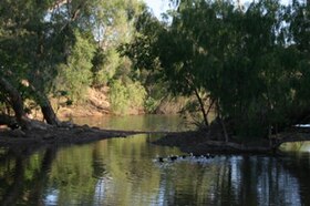
With its headwaters in the Great Dividing Range west of Wujal Wujal in the Wet Tropics of Queensland, the Normanby River is formed by the confluence of the East and West Branches of the river at an elevation of 125 metres (410 ft) AHD . The river flows generally north-northwestw through seasonally flooded savanna grassland to reach its mouth in Princess Charlotte Bay about 150 kilometres (93 mi) northwest of Cooktown. The river is joined by 18 tributaries including the Laura River. The river flows through the Rinyirru National Park, which covers as much as a fifth of the river's basin and is completely impassable during the wet season between November and May. The Rinyirru National Park consists of large wetlands which possess a high diversity of fish species. Near its mouth, the Normanby River flows very slowly and forms a large delta, which is almost inaccessible even during the dry season as there are no roads – even unsealed ones. This land, though, is still dry enough during the dry season that tropical rainforests cannot grow.[ citation needed ]

The combined river system descends from a peak elevation of 622 metres (2,041 ft) AHD to sea level, with a combined course from source to mouth of over 490 kilometres (300 mi). [2] [3] [4] [5] [6] [7]

While one source considers the Normanby River system as the third largest river in Australia, [9] the Australian Government agency, Geoscience Australia, does not assess the Normanby River system within the ten longest rivers in Australia nor within the three longest continuous river systems in the country. [10] The river may be the largest river flowing into the Coral Sea.[ citation needed ] The Normanby River system has less than half the flow of the Murray and Mitchell Rivers - though data regarding its flow are sparse with less than a third of the 24,408-square-kilometre (9,424 sq mi) catchment area gauged.

Environmental

Salvinia molesta is a floating fern. It becomes a thick mat which can smother native aquatic plants, alter stream flow and deplete oxygen levels for aquatic organisms. Salvinia molesta kz01.jpg
Salvinia molesta is a floating fern. It becomes a thick mat which can smother native aquatic plants, alter stream flow and deplete oxygen levels for aquatic organisms.

Together with the Laura River, the Normanby River system is the fourth largest river system in the Great Barrier Reef catchment, with the third largest mean annual discharge into the Reef. [12] Consequently almost all scientific research into the flow and hydrology of the Normanby basin has been done with the health of the reef rather than the river per se in mind. [13] The fact that the Normanby is completely free of dams means that Australian Government studies have used it as a model for the behaviour of rivers further south when they were in something closer to a virgin state.[ citation needed ]

Cooktown orchid - Dendrobium bigibbum. Queensland 2008 Dendrobium bigibbum 47 Philippine Pde Palm Beach IMGP4301.jpg
Cooktown orchid - Dendrobium bigibbum . Queensland 2008

In 2016 the Queensland Government purchased Springvale Station, a 56,295-hectare (139,110-acre) property in Lakeland. Springvale Station was purchased to add to the state's protected area network and complement activities being taken to reduce sediment run-off entering the Normanby River catchment. The Erosion Management Plan will inform the future management planning and activities to be delivered on Springvale Station, as well as identifying potential investment and collaboration opportunities for erosion control on the property. [14] [15] [16]

Springvale Station Nature Refuge provides important habitat for endangered or vulnerable flora and fauna including the Cooktown orchid, ghost bat, northern quoll, red goshawk, spectacled flying-fox, spotted-tailed quoll, Semon's leaf nosed bat and large eared-horseshoe bat. There is no public access on the Nature Refuge. [14]

Industry

The small towns of Lakeland, Laura and Lakefield, several homesteads and remote communities are within the catchment. The Normanby basin is almost entirely used for the grazing of beef cattle on large stations - mostly worked by Aborigines. The density of cattle is very low, as are rents. [17] The soils, being mostly ancient lateritic Orthents, are totally unsuitable for the growing sugar cane, which is the principal crop in tropical Australia. Tourism and maintenance of transport infrastructure after regular floods are important to the area. The estuarine areas support commercial and recreational fisheries. [18] [19]

Etymology

The river was named by William Hann in September 1872 in honour of George Phipps, 2nd Marquess of Normanby, who served as the third Governor of Queensland between 1871 and 1874. [1] [20]

Indigenous language

Guugu Yimithirr (also known as Koko Yindjir, Gugu Yimidhirr, Guguyimidjir) is an Australian Aboriginal language of Hope Vale and the Cooktown area. The language region includes the local government area of the Aboriginal Shire of Hope Vale and the Shire of Cook, particularly the localities of Cape Bedford, Battle Camp and sections of the Normanby River and Annan River. [21]

See also

Related Research Articles

<span class="mw-page-title-main">Endeavour River National Park</span> Protected area in Queensland, Australia

Endeavour River National Park is a national park in Queensland, Australia, gazetted to protect and preserve some of the natural and cultural resources in and around the mouth of the Endeavour River, immediately north of the small town of Cooktown. The park is located 1,561 kilometres (970 mi) northwest of Brisbane.

<span class="mw-page-title-main">Burdekin River</span> River in Queensland, Australia

The Burdekin River is a river in North and Far North Queensland, Australia. The river rises on the northern slopes of Boulder Mountain at Valley of Lagoons, part of the western slope of the Seaview Range, and flows into the Coral Sea at Upstart Bay over 200 kilometres (124 mi) to the southeast of the source, with a catchment area of approximately 130,000 square kilometres (50,000 sq mi). The Burdekin River is Australia's largest river by (peak) discharge volume.

<span class="mw-page-title-main">Guugu Yimithirr people</span> Indigenous Australian people of Queensland

The Guugu Yimithirr, also spelt Gugu Yimithirr and also known as Kokoimudji, are an Aboriginal Australian people of Far North Queensland, many of whom today live at Hopevale, which is the administrative centre of Hopevale Shire. At the 2011 census, Hopevale had a population of 1,005 people. It is about 46 kilometres (29 mi) from Cooktown by road. It is also the name of their language. They were both a coastal and inland people, the former clans referring to themselves as a "saltwater people".

Guugu Yimithirr, also rendered Guugu Yimidhirr, Guguyimidjir, and many other spellings, is an Australian Aboriginal language, the traditional language of the Guugu Yimithirr people of Far North Queensland. It belongs to the Pama-Nyungan language family. Most of the speakers today live at the community of Hope Vale, about 46 kilometres (29 mi) from Cooktown. However, as of June 2020 only about half of the Guugu Yimithirr nation speak the language. As such, efforts are being made to teach it to children. Guugu Yimithirr is the source language of the word kangaroo.

<span class="mw-page-title-main">Lakeland, Queensland</span> Town in Queensland, Australia

Lakeland is a rural town and locality in the Shire of Cook, Queensland, Australia. In the 2016 census, the locality of Lakeland had a population of 299 people.

<span class="mw-page-title-main">Hope Vale, Queensland</span> Town in Queensland, Australia

Hope Vale is a town within the Aboriginal Shire of Hope Vale and a coastal locality split between the Aboriginal Shire of Hope Vale and the Shire of Cook, both in Queensland, Australia. It is an Aboriginal community. In the 2016 census, the locality of Hope Vale had a population of 1,015 people.

<span class="mw-page-title-main">Flinders River</span> River in Queensland, Australia

The Flinders River is the longest river in Queensland, Australia, at approximately 1,004 kilometres (624 mi). It was named in honour of the explorer Matthew Flinders. The catchment is sparsely populated and mostly undeveloped. The Flinders rises on the western slopes of the Great Dividing Range in North West Queensland and flows generally north-west through the Gulf Country, across a large, flat clay pan, before entering the Gulf of Carpentaria.

<span class="mw-page-title-main">Endeavour River</span> River in Queensland, Australia

The Endeavour River, inclusive of the Endeavour River Right Branch, the Endeavour River South Branch, and the Endeavour River North Branch, is a river system located on Cape York Peninsula in Far North Queensland, Australia.

<span class="mw-page-title-main">Palmer River</span> River in Queensland, Australia

The Palmer River is a river in Far North Queensland, Australia. The area surrounding the river was the site of a gold rush in the late 19th century which started in 1873.

<span class="mw-page-title-main">Shire of Cook</span> Local government area in Queensland, Australia

The Shire of Cook is a local government area in Far North Queensland, Australia. The Shire covers most of the eastern and central parts of Cape York Peninsula, the most northerly section of the Australian mainland.

The Laura River is a river in the Cape York Peninsula region of Far North Queensland, Australia.

<span class="mw-page-title-main">Bloomfield River</span> River in Far North Queensland, Australia

The Bloomfield River is a river in the Wet Tropics of Far North Queensland, Australia, noted for its Bloomfield River cod fish species, found only in the river.

<span class="mw-page-title-main">Annan River</span> River in Queensland, Australia

The Annan River is a river in the Wet Tropics of Far North Queensland, Australia.

<span class="mw-page-title-main">Johnstone River</span> River in Queensland, Australia

The Johnstone River, comprising the North Johnstone River and the South Johnstone River, is a river system in Far North and North Queensland, Australia.

<span class="mw-page-title-main">Mulgrave River</span> River in Queensland, Australia

The Mulgrave River, incorporating the East Mulgrave River and the West Mulgrave River, is a river system in Far North Queensland, Australia. The 70-kilometre (43 mi)-long river flows towards the Coral Sea and is located approximately 50 kilometres (31 mi) south of Cairns.

<span class="mw-page-title-main">Cooktown, Queensland</span> Town in Queensland, Australia

Cooktown is a coastal town and locality in the Shire of Cook, Queensland, Australia. Cooktown is at the mouth of the Endeavour River, on Cape York Peninsula in Far North Queensland where James Cook beached his ship, the Endeavour, for repairs in 1770. Both the town and Mount Cook which rises up behind the town were named after James Cook.

<span class="mw-page-title-main">Aboriginal Shire of Hope Vale</span> Local government area in Queensland, Australia

The Aboriginal Shire of Hope Vale is a local government area in Far North Queensland, Queensland, Australia, north of the town of Cooktown. The majority of the Shire consists of Deed of Grant land that is held for the benefit of Aboriginal people particularly concerned with the land and their ancestors and descendants.

The Isaac River is a river and anabranch in Central Queensland, Australia.

<span class="mw-page-title-main">Mossman River</span> River in Far North Queensland, Australia

The Mossman River is a river in lower Cape York Peninsula, Queensland, Australia.

The Esk River is a river in the Wet Tropics of Far North Queensland, Australia.

References

  1. 1 2 "Normanby River". Queensland place names search. Queensland Government . Retrieved 31 October 2015.
  2. 1 2 "Map of Normanby River, QLD". Bonzle Digital Atlas of Australia. Retrieved 31 October 2015.
  3. 1 2 "Map of East Normanby River, QLD". Bonzle Digital Atlas of Australia. Retrieved 31 October 2015.
  4. 1 2 "Map of East Normanby River North Branch, QLD". Bonzle Digital Atlas of Australia. Retrieved 31 October 2015.
  5. 1 2 "Map of East Normanby River South Branch, QLD". Bonzle Digital Atlas of Australia. Retrieved 31 October 2015.
  6. 1 2 "Map of West Normanby River, QLD". Bonzle Digital Atlas of Australia. Retrieved 31 October 2015.
  7. 1 2 "Map of Granite Normanby River, QLD". Bonzle Digital Atlas of Australia. Retrieved 31 October 2015.
  8. "Story Map Series". qgsp.maps.arcgis.com. Introduction. Retrieved 16 February 2023.
  9. Brown, John Alexander Henstridge (1983). Australia's Surface Water Resources. Canberra: Australian Government Publication Service.
  10. "Longest rivers". Geoscience Australia . Australian Government. 21 December 2012. Retrieved 15 June 2013.
  11. "Invasive plants — Cook Shire Council". www.cook.qld.gov.au. Retrieved 3 March 2023.
  12. Howley, Christina (2013). "Normanby River Water Quality: 2006-2013 Monitoring Results" (PDF). Cape York Water Quality. p. 2. Retrieved 31 October 2015.
  13. Gruber, R.; Waterhouse, J.; Logan, M.; Petus, C.; Howley, C.; Lewis, S.; Tracey, D.; Langlois, L.; Tonin, H.; Skuza, M.; Costello, P.; Davidson, J.; Gunn, K.; Lefevre, C.; Moran, D.; Robson, B.; Shanahan, M.; Zagorskis, I.; Shellberg, J.; Neilen, A. (2020). "Marine Monitoring Program: Annual Report for Inshore Water Quality Monitoring 2018-19. Report for the Great Barrier Reef Marine Park Authority" (PDF). Great Barrier Reef Marine Park Authority, Townsville. ISSN   2208-4096 . Retrieved 2 March 2023.
  14. 1 2 The State of Queensland, Department of Environment and Science (7 July 2022). "Springvale Station Nature Refuge | Coastal catchment management". Queensland Government . Retrieved 16 February 2023.
  15. One Search (2018). "Springvale Station erosion management plan". State Library of Queensland . Retrieved 16 February 2023. CC-BY icon.svg Text was copied from this source, which is available under a Attribution 3.0 Australia (CC BY 3.0 AU) license.
  16. Contributed. "Solution at hand for saving Great Barrier Reef". news.griffith.edu.au. Retrieved 16 February 2023.
  17. "Story Map Series". qgsp.maps.arcgis.com. Catchment overview. Retrieved 1 March 2023.
  18. "Story Map Series". qgsp.maps.arcgis.com. Economic values, Physical features. Retrieved 1 March 2023.
  19. "Declared Fish Habitat Area summary - Princess Charlotte Bay". Parks and forests | Department of Environment and Science Queensland Government . 27 September 2012. Retrieved 1 March 2023.
  20. Jack, R. L. (1922). Northmost Australia. Vol. 2. Melbourne: George Robertson and Co. p. 410.
  21. CC BY icon-80x15.png This Wikipedia article incorporates CC-BY-4.0 licensed text from: "Guugu Yimithirr". Queensland Aboriginal and Torres Strait Islander languages map. State Library of Queensland . Retrieved 28 January 2020.