
The Great Dividing Range, also known as the East Australian Cordillera or the Eastern Highlands, is a cordillera system in eastern Australia consisting of an expansive collection of mountain ranges, plateaus and rolling hills, that runs roughly parallel to the east coast of Australia and forms the fifth-longest land-based mountain chain in the world, and the longest entirely within a single country. It is mainland Australia's most substantial topographic feature and serves as the definitive watershed for the river systems in eastern Australia, hence the name.

Bruxner Highway, and its former western alignment as Bruxner Way, are a 420-kilometre (260 mi) state highway and rural road respectively, located in New South Wales, Australia. The route forms an east–west link across the Northern Tablelands in northern New South Wales, close to the border with Queensland, to the Northern Rivers coast. It was named after Michael Bruxner, NSW Minister for Transport from 1932 to 1941.

Castlereagh Highway is a 790-kilometre (490 mi) state highway located in New South Wales and Queensland, Australia. From north to south the highway traverses South West Queensland and the North West Slopes, Orana, and Central West regions of New South Wales.

The Warrego Highway is located in southern Queensland, Australia. It connects coastal centres to the south western areas of the state, and is approximately 715 km in length. It takes its name from the Warrego River, which is the endpoint of the highway. The entire highway is part of the National Highway system linking Darwin and Brisbane: formerly National Highway 54, Queensland began to convert to the alphanumeric system much of Australia had adopted in the early-2000s and this road is now designated as National Highway A2.

The Moonie Highway is a state highway of Queensland, Australia. Part of State Route 49, it leaves the Warrego Highway at Dalby and runs for over 290 km until it reaches St George. From there, State Route 49 continues west as the Balonne Highway. From Dalby, it continues north-east as the Bunya Highway.
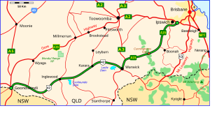
The Cunningham Highway is a 327-kilometre (203 mi) national highway located in south-eastern Queensland, Australia. The highway links the Darling Downs region with the urbanised outskirts of Ipswich via Cunninghams Gap.

The Barkly Highway is a national highway of both Queensland and the Northern Territory in Australia. It is the only sealed road between Queensland and the Northern Territory.

Far North Queensland (FNQ) is the northernmost part of the Australian state of Queensland. Its largest city is Cairns and it is dominated geographically by Cape York Peninsula, which stretches north to the Torres Strait, and west to the Gulf Country. The waters of Torres Strait include the only international border in the area contiguous with the Australian mainland, between Australia and Papua New Guinea.

The Isis Highway is a state highway in southern Queensland, Australia. The highway is relatively short, and runs for 137 kilometres (85 mi) in a north-east / south-west direction between Bundaberg North and the Burnett Highway at Ban Ban Springs. The Isis Highway links the sugar producing Bundaberg and Fraser Coast regions with the cattle farming districts of the North Burnett.
The Dawson River is a river in Central Queensland, Australia.

The Georgina River is the north-westernmost of the three major rivers of the Channel Country in Central West Queensland, that also flows through a portion of the Northern Territory, in central Australia. Part of the Lake Eyre basin, the Georgina flows in extremely wet years into Lake Eyre.
The Laura River is a river in the Cape York Peninsula region of Far North Queensland, Australia.

The Maranoa River, part of the Murray-Darling basin, is a river situated in South West Queensland, Australia.

The Moonie River (Mooni River) is a river in Shire of Balonne, Queensland and Walgett Shire, New South Wales, both in Australia. It is a perennial river of the Barwon catchment within the Murray–Darling basin.
Narran River, a watercourse of the Barwon catchment within the Murray–Darling basin, is located in the Southern Downs district of Queensland and Orana district of New South Wales, Australia.
The Don River is a river in North Queensland, Australia.

The Nive River is a river that is part of the Darling catchment within the Murray–Darling basin, is located in the south west region of Queensland, Australia.
The Dee River is a river in Central Queensland, Australia.
The Weir River, a river that is part of the Border Rivers group and also forms part of the Barwon River catchment in the Murray–Darling basin, is located in the Darling Downs region of Queensland, Australia.
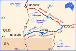
The Birdsville Developmental Road is a mostly unsealed road in south-west Queensland that branches off the Diamantina Developmental Road at a point 103 kilometres (64 mi) west of Windorah and runs to Birdsville. Its length is 273 kilometres (170 mi). The road crosses a major channel of the Diamantina River just before reaching Birdsville. It links with Cordillo Downs road and Arrabury Road, both of which lead to the South Australian town of Innamincka.
