Burnett Highway

Last updated

Burnett Highway

Burnett Highway 1912.svg
Burnett Highway (green on black)
General information
TypeHighway
Length542 km (337 mi)
Route number(s)
  • AUS Alphanumeric Route A3.svg A3
  • (Entire Route)
  • Duplexes
  • Australian state route 60.svg State Route 60
  • (Biloela West – Biloela)
  • Australian state route 49.svg State Route 49
  • (Goomeri – Goomeri South)
Former
route number
Australian national route 17.svg National Route 17
Major junctions
North endAUS Alphanumeric Route A1.svg Bruce Highway (Queensland Highway A1), Gracemere
 
South endAUS Alphanumeric Route A3.svgAustralian state route 96.svg D'Aguilar Highway (State Highway A3 / State Route 96), Nanango
Location(s)
Major settlements Mt. Morgan, Dululu, Biloela, Monto, Eidsvold, Mundubbera, Gayndah, Ban Ban Springs, Goomeri
Highway system

The Burnett Highway is an inland rural highway located in Queensland, Australia. The highway runs from its junction with the Bruce Highway at Gracemere, just south of Rockhampton, to the D'Aguilar Highway in Nanango. Its length is approximately 542 kilometres. The highway takes its name from the Burnett River, which it crosses in Gayndah. The Burnett Highway provides the most direct link between the northern end of the New England Highway (at Yarraman, 21 kilometres (13 mi) south of Nanango) and Rockhampton. It is designated as a State Strategic Road (part of Australia’s Country Way) by the Queensland Government. [1]

Contents

State-controlled road

Burnett Highway is a state-controlled regional road, most of which is rated as "state-strategic". It is defined in six sections, as follows:

History

In January 2013, Cyclone Oswald caused flood damage to the road and a partial closure between Bouldercombe and Mount Morgan, which took longer than a year to repair. [5]

Roads of Strategic Importance upgrade

The Roads of Strategic Importance initiative, last updated in March 2022, includes the following project for the Burnett Highway.

Intersection upgrade

A project to upgrade the intersection of the Burnett Highway with Gayndah-Mount Perry Road and Wetherton Road, at an estimated cost of $875,000, is expected to be completed in late 2022. [6]

Other upgrades

Replace bridges

A project to replace the bridge over Three Moon Creek, at a cost of $18 million, was completed in August 2021. [7]

A project to replace the bridge over North Kariboe Creek, at a cost of $7.2 million, was completed in September 2021. [8]

Strengthen and widen bridge

A project to strengthen and widen the bridge over Callide Creek, at a cost of $3.9 million, was due for completion in early 2022. [9]

List of towns on the Burnett Highway

From north to south

Major intersections

LGALocationkmmiDestinationsNotes
Rockhampton Gracemere 00.0AUS Alphanumeric Route A1.svg Bruce Highway (Queensland Highway A1) north – Rockhampton /
south – Mount Larcom
Northern end of Burnett Highway.
Banana Dululu 63.039.1AUS Alphanumeric Route A5.svg Leichhardt Highway (State Route A5) north–west – Westwood /
south–west – Wowan
Biloela 135.183.9Australian state route 60.svg Dawson Highway (State Route 60) west – Banana /
east – Calliope
North–western concurrency terminus with Dawson Highway
136.384.7Australian state route 60.svg Dawson Highway (State Route 60) west – Banana /
east – Calliope
South–eastern concurrency terminus with Dawson Highway
North Burnett Monto 230140Australian state route 69.svg Gladstone–Monto Road (State Route 69) – north–east – Many Peaks
Eidsvold 303188Australian state route 73.svg Eidsvold–Theodore Road (State Route 73) – south, then west – Theodore
Mundubbera 338.3210.2Australian state route 75.svg Mundubbera–Durong Road (State Route 75) – south–west – Durong
Burnett River 381.3236.9Les Baker Bridge
North Burnett Ban Ban Springs 408.1253.6Australian state route 52.svg Isis Highway (State Route 52) north–east – Childers
Gympie Goomeri 482.3299.7Australian state route 49.svg Wide Bay Highway (State Route 49) east – Gympie Northern concurrency terminus with State Route 49
484.1300.8Australian state route 49.svg Bunya Highway (State Route 49) west – Murgon Southern concurrency terminus with State Route 49
South Burnett Nanango 542.3337.0AUS Alphanumeric Route A3.svgAustralian state route 96.svg D'Aguilar Highway (State Route A3) south – Yarraman /
(State Route 96) north–west – Kingaroy
Southern end of Burnett Highway.
1.000 mi = 1.609 km; 1.000 km = 0.621 mi

Intersecting state-controlled roads

The following state-controlled roads, from south to north, intersect with the Burnett Highway:

Murgon–Barambah Road

Murgon–Barambah Road

LocationKilcoy–Murgon Road, Murgon to Burnett Highway, Barambah
Length14.1 km (8.8 mi)

Murgon–Barambah Road is a state-controlled regional road (number 437), rated as a local road of regional significance (LRRS). [2] [3] It runs from Kilcoy–Murgon Road in Murgon to the Burnett Highway in Barambah, a distance of 14.1 kilometres (8.8 mi). It does not intersect with any state-controlled roads. [10]

Wuruma Dam Road

Wuruma Dam Road

LocationBurnett Highway, Cynthia to Wuruma Dam Campground, Wuruma Dam
Length28.8 km (17.9 mi)

Wuruma Dam Road is a state-controlled district road (number 4511), rated as a local road of regional significance (LRRS). [2] [3] It runs from the Burnett Highway in Cynthia to the Wuruma Dam Campground in the locality of Wuruma Dam, a distance of 28.8 kilometres (17.9 mi). It does not intersect with any state-controlled roads. [11]

Cania Dam Road

Cania Dam Road

LocationBurnett Highway, Moonford to Cania Dam, Cania
Length24 km (15 mi)

Cania Dam Road is a state-controlled district road (number 4715), rated as a local road of regional significance (LRRS). [2] [3] It runs from the Burnett Highway in Moonford to Cania Dam in the locality of Cania, a distance of 24 kilometres (15 mi). It does not intersect with any state-controlled roads. [12]

Gavial–Gracemere Road

Gavial–Gracemere Road

LocationBruce Highway, Midgee to Capricorn Highway, Gracemere
Length10.8 km (6.7 mi)

Gavial–Gracemere Road is a state-controlled district road (number 450). [2] [4] It runs from the Bruce Highway in Midgee to the Capricorn Highway in Gracemere, a distance of 10.8 kilometres (6.7 mi). It crosses the Burnett Highway in Bouldercombe. [13]

A project to widen part of this road to four lanes was completed in April 2023. [14]

See also

Related Research Articles

<span class="mw-page-title-main">Burnett River</span> River in Queensland, Australia

The Burnett River is a river in the Wide Bay–Burnett and Central Queensland regions of Queensland, Australia.

<span class="mw-page-title-main">Bunya Highway</span> Highway in Queensland

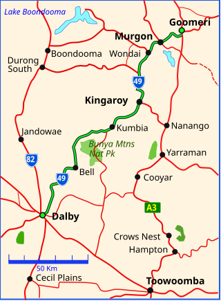
The Bunya Highway is a state highway of Queensland, Australia. It is a relatively short road, running approximately 173 kilometres in a south-westerly direction from Goomeri to Dalby. The highway connects the Warrego and Burnett Highways.

<span class="mw-page-title-main">D'Aguilar Highway</span> Highway in Queensland, Australia

The D'Aguilar Highway is a two-lane highway linking the Bruce Highway near Caboolture with the Bunya Highway in Kingaroy in the state of Queensland, Australia. Major towns along the route include Woodford, Kilcoy, Blackbutt, Yarraman, and Nanango. The highway is approximately 164 km (102 mi) in length. The D'Aguilar Highway's highest elevation along its length is 527 m just north of Yarraman, and the lowest point is at 26.8 m just west of Caboolture.

<span class="mw-page-title-main">Murgon</span> Town in Queensland, Australia

Murgon is a rural town and locality in the South Burnett Region, Queensland, Australia. In the 2016 census, the locality of Murgon had a population of 2,378 people.

<span class="mw-page-title-main">Goomeri</span> Town in Queensland, Australia

Goomeri is a rural town and locality in the Gympie Region, Queensland, Australia. In the 2016 census, the locality of Goomeri had a population of 664 people.

<span class="mw-page-title-main">Shire of Monto</span> Local government area in Queensland, Australia

The Shire of Monto was a local government area in the northern catchment of the Burnett River, Queensland, Australia. The shire covered an area of 4,320.8 square kilometres (1,668.3 sq mi), and existed as a local government area from 1932 until 2008, when it amalgamated with several other shires to form the North Burnett Region.

<span class="mw-page-title-main">Tingoora</span> Town in Queensland, Australia

Tingoora is a rural town and a locality in the South Burnett Region, Queensland, Australia.

<span class="mw-page-title-main">Wide Bay–Burnett</span> Region in Queensland, Australia

Wide Bay–Burnett is a region of the Australian state of Queensland, located between 170–400 km (110–250 mi) north of the state capital, Brisbane. The area's population growth has exceeded the state average over the past 20 years, and it is forecast to grow to more than 430,000 by 2031. It is the subject of the Draft Wide Bay–Burnett Regional Plan, which aims to facilitate this growth while protecting over 90% of the region from urban development.

Wakka Wakka, or Waka Waka, people are an Aboriginal Australian community of the state of Queensland.

<span class="mw-page-title-main">Abercorn, Queensland</span> Suburb of North Burnett Region, Queensland, Australia

Abercorn is a rural town and locality in the North Burnett Region, Queensland, Australia. In the 2016 census, the locality of Abercorn had a population of 46 people.

The Kilkivan to Kingaroy Rail Trail is an 88-kilometre (55 mi) recreation trail from Kilkivan to Kingaroy. The trail follows the old Kingaroy Branch railway and is open to walkers, cyclists and horse riders.

Kilcoy-Murgon Road is a major inland rural road located in Queensland, Australia. It is a state-controlled district road rated as a local road of regional significance (LRRS).

<span class="mw-page-title-main">Kinbombi</span> Town in Queensland, Australia

Kinbombi is a rural town and locality in the Gympie Region, Queensland, Australia. In the 2016 census, the locality of Kinbombi had a population of 37 people.

<span class="mw-page-title-main">Stonelands</span> Suburb of South Burnett Region, Queensland, Australia

Stonelands is a rural locality in the South Burnett Region, Queensland, Australia. In the 2016 census, Stonelands had a population of 51 people.

Goomeribong is a rural locality in the Gympie Region, Queensland, Australia. In the 2021 census, Goomeribong had a population of 49 people.

<span class="mw-page-title-main">Cania, Queensland</span> Suburb of North Burnett Region, Queensland, Australia

Cania is a locality in the North Burnett Region, Queensland, Australia. In the 2021 census, Cania had a population of 27 people.

Gladstone–Monto Road is a 132 kilometres (82 mi) road route in the Gladstone and North Burnett regions of Queensland, Australia. The entire route is signed as State Route 69.

Gin Gin–Mount Perry–Monto Road is a continuous 109.4 kilometres (68.0 mi) road route in the Bundaberg and North Burnett regions of Queensland, Australia. It has two official names, Gin Gin–Mount Perry Road and Monto–Mount Perry Road. The entire route is signed as State Route 12.

Eidsvold–Theodore Road is a continuous 143.7 kilometres (89.3 mi) road route in the North Burnett and Banana regions of Queensland, Australia. The entire route is signed as State Route 73. It is a state-controlled district road rated as a local road of regional significance.

Mundubbera–Durong Road is a continuous 105-kilometre (65 mi) road route in the North Burnett and South Burnett local government areas of Queensland, Australia. It is signed as State Route 75. It is a state-controlled regional road. It has been designated as a road of strategic importance by the Federal Government.

References

  1. "Queensland Government - Department of Transport and Main Roads - Maps". Archived from the original on 19 March 2018. Retrieved 20 April 2014.
  2. 1 2 3 4 5 The State Road Network of Queensland (PDF) (Map). Queensland Government ©State of Queensland [CC BY 4.0]. 30 June 2022. Retrieved 4 August 2023.
  3. 1 2 3 4 "Wide Bay / Burnett district map - Page 1" (PDF). Department of Transport and Main Roads ©State of Queensland [CC BY 4.0]. 5 August 2021. Retrieved 29 November 2021.
  4. 1 2 "Fitzroy district map" (PDF). Department of Transport and Main Roads ©State of Queensland [CC BY 4.0]. 2019. Retrieved 7 April 2022.
  5. Austin King (12 April 2014). "Burnett Hwy still closed more than a year after landslide". The Morning Bulletin. Capricornia Newspapers. Retrieved 29 July 2014.
  6. "Burnett Highway - Gayndah-Mount Perry Road - Wetherton Road - Intersection Upgrade". Department of Infrastructure, Transport, Regional Development and Communications. 29 March 2022. Retrieved 6 May 2022.
  7. "Burnett Highway (Gayndah-Monto), Eidsvold, -Three Moon Creek bridge replacement". Queensland Government. 2 February 2022. Retrieved 31 May 2022.
  8. "Burnett Highway (Monto-Biloela), North Kariboe Creek, replace bridge". Queensland Government. 23 November 2021. Retrieved 31 May 2022.
  9. "Burnett Highway (Biloela-Mount Morgan), Callide Creek, strengthen and widen bridge". Queensland Government. 22 November 2021. Retrieved 31 May 2022.
  10. Google (5 November 2022). "Murgon to Barambah" (Map). Google Maps . Google. Retrieved 5 November 2022.
  11. Google (5 November 2022). "Cynthia to Wuruma Dam" (Map). Google Maps . Google. Retrieved 5 November 2022.
  12. Google (5 November 2022). "Moonford to Cania" (Map). Google Maps . Google. Retrieved 5 November 2022.
  13. Google (5 November 2022). "Midgee to Gracemere" (Map). Google Maps . Google. Retrieved 5 November 2022.
  14. "Gavial - Gracemere Road (Lawrie Street), widen to four lanes and upgrade intersections". Queensland Government. 30 October 2023. Retrieved 5 November 2023.